Tropical cyclone
2007 Schools Wikipedia Selection. Related subjects: Storms
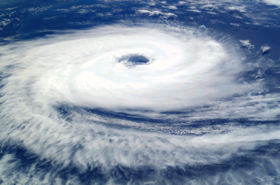
A ''tropical cyclone'' is a storm system fueled by the heat released when moist air rises and the water vapor in it condenses. The term describes the storm's origin in the tropics and its cyclonic nature, which means that its circulation is counterclockwise in the northern hemisphere and clockwise in the southern hemisphere. Tropical cyclones are distinguished from other cyclonic windstorms such as nor'easters, European windstorms, and polar lows by the heat mechanism that fuels them, which makes them "warm core" storm systems.
Depending on their location and strength, there are various terms by which tropical cyclones are known, such as hurricane, typhoon, tropical storm, cyclonic storm and tropical depression.
Tropical cyclones can produce extremely strong winds, tornadoes, torrential rain, high waves, and storm surges. They are born and sustained over large bodies of warm water and lose their strength over land; this explains why coastal regions can receive much damage while inland regions are relatively safe. The heavy rains and storm surges can produce extensive flooding. Although their effects on human populations can be devastating, tropical cyclones also can have beneficial effects by relieving drought conditions. They carry heat away from the tropics, an important mechanism of the global atmospheric circulation that maintains equilibrium in the earth's troposphere.
Mechanics of tropical cyclones
Structurally, a tropical cyclone is a large, rotating system of clouds, wind, and thunderstorms. Its primary energy source is the release of the heat of condensation from water vapor condensing at high altitudes, the heat being ultimately derived from the sun. Therefore, a tropical cyclone can be thought of as a giant vertical heat engine supported by mechanics driven by physical forces such as the rotation and gravity of the Earth. In another way, tropical cyclones could be viewed as a special type of Mesoscale Convective Complex, which continues to develop over a vast source of relative warmth and moisture. Condensation leads to higher wind speeds, as a tiny fraction of the released energy is converted into mechanical energy; the faster winds and lower pressure associated with them in turn cause increased surface evaporation and thus even more condensation. Much of the released energy drives updrafts that increase the height of the storm clouds, speeding up condensation. This gives rise to factors that provide the system with enough energy to be self-sufficient and cause a positive feedback loop, where it can draw more energy as long as the source of heat, warm water, remains. Factors such as a continued lack of equilibrium in air mass distribution would also give supporting energy to the cyclone. The rotation of the earth causes the system to spin, an effect known as the Coriolis effect, giving it a cyclonic characteristic and affecting the trajectory of the storm.
The factors to form a tropical cyclone include a pre-existing weather disturbance, warm tropical oceans, moisture, and relatively light winds aloft. If the right conditions persist and allow it to create a feedback loop by maximizing the energy intake possible – for example, such as high winds to increase the rate of evaporation – they can combine to produce the violent winds, incredible waves, torrential rains, and floods associated with this phenomenon.
Condensation as a driving force is what primarily distinguishes tropical cyclones from other meteorological phenomena. Because this is strongest in a tropical climate, this defines the initial domain of the tropical cyclone. By contrast, mid-latitude cyclones draw their energy mostly from pre-existing horizontal temperature gradients in the atmosphere. To continue to drive its heat engine, a tropical cyclone must remain over warm water, which provides the needed atmospheric moisture. The evaporation of this moisture is accelerated by the high winds and reduced atmospheric pressure in the storm, resulting in a positive feedback loop. As a result, when a tropical cyclone passes over land, its strength diminishes rapidly.
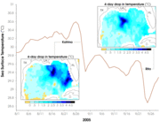
The passage of a tropical cyclone over the ocean can cause the upper ocean to cool substantially, which can influence subsequent cyclone development. Tropical cyclones cool the ocean by acting like "heat engines" that transfer heat from the ocean surface to the atmosphere through evaporation. Cooling is also caused by upwelling of cold water from below. Additional cooling may come from cold water from raindrops that remain on the ocean surface for a time. Cloud cover may also play a role in cooling the ocean by shielding the ocean surface from direct sunlight before and slightly after the storm passage. All these effects can combine to produce a dramatic drop in sea surface temperature over a large area in just a few days.
Scientists at the National Centre for Atmospheric Research estimate that a tropical cyclone releases heat energy at the rate of 50 to 200 trillion joules per day. For comparison, this rate of energy release is equivalent to exploding a 10-megaton nuclear bomb every 20 minutes or 200 times the world-wide electrical generating capacity per day.
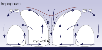
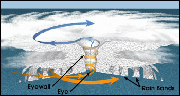
While the most obvious motion of clouds is toward the centre, tropical cyclones also develop an upper-level (high-altitude) outward flow of clouds. These originate from air that has released its moisture and is expelled at high altitude through the "chimney" of the storm engine. This outflow produces high, thin cirrus clouds that spiral away from the centre. The high cirrus clouds may be the first signs of an approaching tropical cyclone.
Physical structure
A strong tropical cyclone consists of the following components:
- Surface low: All tropical cyclones rotate around an area of low atmospheric pressure near the Earth's surface. The pressures recorded at the centers of tropical cyclones are among the lowest that occur on Earth's surface at sea level.
- Warm core: Tropical cyclones are characterized and driven by the release of large amounts of latent heat of condensation as moist air is carried upwards and its water vapor condenses. This heat is distributed vertically, around the centre of the storm. Thus, at any given altitude (except close to the surface where water temperature dictates air temperature) the environment inside the cyclone is warmer than its outer surroundings.
- Central Dense Overcast (CDO): The Central Dense Overcast is the shield of cirrus clouds produced by the eyewall thunderstorms. Typically, these are the highest and coldest clouds in the cyclone.
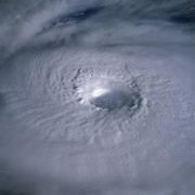
- Eye: A strong tropical cyclone will harbor an area of sinking air at the center of circulation. Weather in the eye is normally calm and free of clouds (however, the sea may be extremely violent). The eye is normally circular in shape, and may range in size from 3 km to 320 km (2 miles to 200 miles) in diameter. In weaker cyclones, the CDO covers the circulation centre, resulting in no visible eye.
- Eyewall: A band around the eye of greatest wind speed, where clouds reach highest and precipitation is heaviest. The heaviest wind damage occurs where a hurricane's eyewall passes over land.
- Rainbands: Bands of showers and thunderstorms that spiral cyclonically toward the storm centre. High wind gusts and heavy downpours often occur in individual rainbands, with relatively calm weather between bands. Tornadoes often form in the rainbands of landfalling tropical cyclones. Annular hurricanes are distinctive for their lack of rainbands.
- Outflow: The upper levels of a tropical cyclone feature winds headed away from the centre of the storm with an anticyclonic rotation. Winds at the surface are strongly cyclonic, weaken with height, and eventually reverse themselves. Tropical cyclones owe this unique characteristic to the warm core at the centre of the storm.
Formation
Factors in formation
The formation of tropical cyclones is the topic of extensive ongoing research and is still not fully understood. Six factors appear to be generally necessary, although tropical cyclones may occasionally form without meeting all of these conditions:
- Water temperatures of at least 26.5 °C (80°F) down to a depth of at least 50 m (150 feet). Waters of this temperature cause the overlying atmosphere to be unstable enough to sustain convection and thunderstorms.
- Rapid cooling with height. This allows the release of latent heat, which is the source of energy in a tropical cyclone.
- High humidity, especially in the lower-to-mid troposphere. When there is a great deal of moisture in the atmosphere, conditions are more favourable for disturbances to develop.
- Low wind shear. When wind shear is high, the convection in a cyclone or disturbance will be disrupted, preventing formation of the feedback loop.
- Distance from the equator. This allows the Coriolis force to deflect winds blowing towards the low pressure centre, causing a circulation. The minimum distance is about 500 km (310 miles) or 5 degrees from the equator.
- A pre-existing system of disturbed weather. The system must have some sort of circulation as well as a low pressure centre.
Generally, tropical cyclones generally form from four different types of systems: monsoon troughs, tropical waves, non-tropical lows, and decaying frontal boundaries. Monsoon troughs, which are broad areas of converging winds from both hemispheres, are the main trigger of tropical cyclone formation worldwide. When they strengthen, either due to strengthening high pressure poleward of the trough or by increased flow passing through the equator from the opposite hemisphere, thunderstorm activity increases and tropical cyclogenesis can occur.
Another common mechanism for tropical cyclone formation are tropical waves, also called easterly waves, which are westward-moving areas of convergent winds. These generate most of the hurricanes in the Atlantic and northeast Pacific basins. Tropical waves often carry with them clusters of thunderstorms, which can then develop into tropical cyclones. A similar phenomenon to tropical waves are West African disturbance lines, which are squalls that form over Africa and move into the Atlantic, often as a part of the Intertropical Convergence Zone. Tropical cyclones also frequently form from upper tropospheric troughs, which are cold-core upper-level lows. A warm-core tropical cyclone may result when one of these works down to the lower levels of the atmosphere and produces deep convection. Off-season tropical cyclones most often form in this manner. Finally, decaying frontal boundaries may occasionally stall over warm waters and produce lines of active convection. If a low-level circulation forms under this convection, it may develop into a tropical cyclone.
Locations of formation
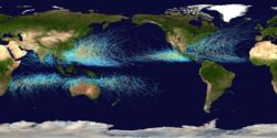
Most tropical cyclones form in a worldwide band of thunderstorm activity called by several names: the Intertropical Discontinuity (ITD), the Intertropical Convergence Zone (ITCZ), or the monsoon trough.
Most of these systems form between 10 and 30 degrees of the equator and 87% form within 20 degrees of it. Because the Coriolis effect initiates and maintains tropical cyclone rotation, tropical cyclones rarely form or move within about 5 degrees of the equator, where the Coriolis effect is weakest. However, it is possible for tropical cyclones to form within this boundary as did Typhoon Vamei in 2001 and Cyclone Agni in 2004.
Major basins
Traditionally, areas of tropical cyclone formation are divided into seven basins. These include the north Atlantic Ocean, the eastern and western parts of the Pacific Ocean (considered separately because tropical cyclones rarely form in the central Pacific), the southwestern Pacific, the southwestern and southeastern Indian Oceans, and the northern Indian Ocean. The North Atlantic is the most studied of the basins, while the Western Pacific is the most active and the North Indian the least active. An average of 86 tropical cyclones of tropical storm intensity form annually worldwide, with 47 reaching hurricane/typhoon strength, and 20 becoming intense tropical cyclones (at least of Category 3 intensity).
| Basins and WMO Monitoring Institutions | |
|---|---|
| Basin | Responsible RSMCs and TCWCs |
| Northern Atlantic | National Hurricane Centre |
| Northeastern Pacific | National Hurricane Centre |
| North central Pacific | Central Pacific Hurricane Centre |
| Northwestern Pacific | Japan Meteorological Agency |
| Northern Indian | Indian Meteorological Department |
| Southwestern Indian | Météo-France |
| South and Southwestern Pacific |
Fiji Meteorological Service Meteorological Service of New Zealand† Papua New Guinea National Weather Service† Bureau of Meteorology† (Australia) |
| Southeastern Indian | Bureau of Meteorology† (Australia) |
| †: Indicates a Tropical Cyclone Warning Centre | |
There are six Regional Specialised Meteorological Centres (RSMCs) worldwide. These organizations are designated by the World Meteorological Organization and are responsible for tracking and issuing bulletins, warnings, and advisories about tropical cyclones in their designated areas of responsibility. Additionally, there are five Tropical Cyclone Warning Centres (TCWCs) that provide information to smaller regions. The RSMCs and TCWCs, however, are not the only organizations that provide information about tropical cyclones to the public. The Joint Typhoon Warning Centre (JTWC) issues informal advisories in all basins except the Northern Atlantic and Northeastern Pacific. The Philippine Atmospheric, Geophysical and Astronomical Services Administration (PAGASA) issues informal advisories, as well as names, for tropical cyclones that approach the Philippines in the Northwestern Pacific. The Canadian Hurricane Centre (CHC) issues advisories on hurricanes and their remnants that affect Canada.
- Northern Atlantic Ocean: The most-studied of all tropical basins, it includes the Atlantic Ocean, the Caribbean Sea, and the Gulf of Mexico. Tropical cyclone formation here varies widely from year to year, ranging from over twenty to one per year with an average of around ten. The United States Atlantic coast, Mexico, Central America, the Caribbean Islands, and Bermuda are frequently affected by storms in this basin. Venezuela, the south-east of Canada and Atlantic "Macaronesian" islands are also occasionally affected. Many of the more intense Atlantic storms are Cape Verde-type hurricanes, which form off the west coast of Africa near the Cape Verde islands. Rarely, a hurricane can reach western Europe, including Hurricane Lili, which dissipated over the British Isles in October 1996, and Tropical Storm Vince, which made landfall on the southwestern coast of Spain in September 2005.
- Northeastern Pacific Ocean: This is the second most active basin in the world, and the most dense (a large number of storms for a small area of ocean). Storms that form here can affect western Mexico, Texas, Hawaii, northern Central America, California, Arizona, and on rare occasions, Japan. No hurricane included in the modern database has reached California; however, historical records from 1858 speak of a storm that struck San Diego with winds over 75 m.p.h./65 kts, above hurricane force, though it is not known if the storm actually made landfall. Since 1900, only one system of tropial storm strength has made landfall in California.
- Northwestern Pacific Ocean: Tropical storm activity in this region frequently affects China, Japan, Hong Kong, the Philippines, and Taiwan, but also many other countries in Southeast Asia, such as Vietnam, South Korea, and parts of Indonesia, plus numerous Oceanian islands. This is by far the most active basin, accounting for one-third of all tropical cyclone activity in the world. The coast of China sees the most landfalling tropical cyclones worldwide. The Philippines receives an average 18 typhoon landings per year. Rarely does a typhoon or an extratropical storm reach northward to Siberia, Russia.
- Northern Indian Ocean: This basin is divided into two areas, the Bay of Bengal and the Arabian Sea, with the Bay of Bengal dominating (5 to 6 times more activity). This basin's season has an interesting double peak; one in April and May before the onset of the monsoon, and another in October and November just after.(see data, ) Tropical cyclones which form in this basin have historically cost the most lives — most notably, the 1970 Bhola cyclone killed 200,000. Nations affected by this basin include India, Bangladesh, Sri Lanka, Thailand, Myanmar, and Pakistan. Rarely, a tropical cyclone formed in this basin will affect the Arabian Peninsula.
- Southwestern Pacific Ocean: Tropical activity in this region largely affects Australia and Oceania. On rare occasions, tropical storms reach the vicinity of Brisbane, Australia and into New Zealand, usually during or after extratropical transition.
- Southeastern Indian Ocean: Tropical activity in this region affects Australia and Indonesia. According to the Australian Bureau of Meteorology, the most frequently hit portion of Australia is between Exmouth and Broome in Western Australia.
- Southwestern Indian Ocean: This basin is the least understood, due to a lack of historical data. Cyclones forming here impact Madagascar, Mozambique, Mauritius, Reunion, Comoros, Tanzania, and Kenya.
Times of formation
Worldwide, tropical cyclone activity peaks in late summer when water temperatures are warmest. However, each particular basin has its own seasonal patterns. On a worldwide scale, May is the least active month, while September is the most active.
In the North Atlantic, a distinct hurricane season occurs from June 1 to November 30, sharply peaking from late August through September. The statistical peak of the North Atlantic hurricane season is September 10. The Northeast Pacific has a broader period of activity, but in a similar time frame to the Atlantic. The Northwest Pacific sees tropical cyclones year-round, with a minimum in February and a peak in early September. In the North Indian basin, storms are most common from April to December, with peaks in May and November.
In the Southern Hemisphere, tropical cyclone activity begins in late October and ends in May. Southern Hemisphere activity peaks in mid-February to early March.
| Season Lengths and Seasonal Averages | |||||
|---|---|---|---|---|---|
| Basin | Season Start | Season End | Tropical Storms (>34 knots) | Tropical Cyclones (>63 knots) | Category 3+ Tropical Cyclones (>95 knots) |
| Northwest Pacific | – | – | 26.7 | 16.9 | 8.5 |
| South Indian | October | May | 20.6 | 10.3 | 4.3 |
| Northeast Pacific | May | November | 16.3 | 9.0 | 4.1 |
| North Atlantic | June | November | 10.6 | 5.9 | 2.0 |
| Australia Southwest Pacific | October | May | 10.6 | 4.8 | 1.9 |
| North Indian | April | December | 5.4 | 2.2 | 0.4 |
Movement and track
Large-scale winds
Although tropical cyclones are large systems generating enormous energy, their movements over the earth's surface are controlled by large-scale winds—the streams in the earth's atmosphere. The path of motion is referred to as a tropical cyclone's track, and has been compared by Dr. Neil Frank, former director of the National Hurricane Centre, as "leaves carried along by a stream."
The major force affecting the track of tropical systems in all areas are winds circulating around high-pressure areas. Over the north Atlantic Ocean, tropical systems are steered generally westward by the east-to-west winds on the south side of the "Bermuda High", a persistent high-pressure area over the north Atlantic. Also, in the area of the North Atlantic where hurricanes form, trade winds, which are prevailing westward-moving wind currents, steer tropical waves westward from the African coast and towards the Caribbean and North America. These waves are the precursors to many tropical cyclones and are the main source of Atlantic hurricanes during most seasons, and also play a significant role in the formation of tropical cyclones in the Eastern Pacific.
In the Indian Ocean and western Pacific (north and south of the equator), tropical cyclogenesis is strongly influenced by the seasonal movement of the Intertropical Convergence Zone and the monsoon trough, rather than by easterly waves. In these basins as well, tropical cyclone paths are broadly determined by synoptic scale features.
Coriolis effect
The earth's rotation also imparts an acceleration (termed the Coriolis Acceleration or Coriolis Effect). This acceleration causes cyclonic systems to turn towards the poles in the absence of strong steering currents (i.e. in the north, the northern part of the cyclone has winds to the west, and the Coriolis force pulls them slightly north. The southern part is pulled south, but since it is closer to the equator, the Coriolis force is a bit weaker there). Thus, tropical cyclones in the Northern Hemisphere, which commonly move west in the beginning, normally turn north (and are then usually blown east), and cyclones in the Southern Hemisphere are deflected south, if no strong pressure systems are counteracting the Coriolis acceleration. The Coriolis acceleration also initiates cyclonic rotation, but it is not the driving force that brings this rotation to high speeds. These speeds are due to the conservation of angular momentum - air is drawn in from an area much larger than the cyclone such that the tiny rotational speed (originally imparted by the Coriolis acceleration) is magnified greatly as the air is drawn in to the low pressure centre.
Interaction with high and low pressure systems
Finally, when a tropical cyclone moves into higher latitude, its general track around a high-pressure area can be deflected significantly by winds moving toward a low-pressure area. Such a track direction change is termed recurve. A hurricane moving from the Atlantic toward the Gulf of Mexico, for example, will recurve to the north and then northeast if it encounters winds blowing northeastward toward a low-pressure system passing over North America. Many tropical cyclones along the East Coast and in the Gulf of Mexico are eventually forced toward the northeast by low-pressure areas which move from west to east over North America.
Landfall
Officially, " landfall" is when a storm's center (the centre of the eye, not its edge) reaches land. Naturally, storm conditions may be experienced on the coast and inland well before landfall. In fact, for a storm moving inland, the landfall area experiences half the storm before the actual landfall. For emergency preparedness, actions should be timed from when a certain wind speed will reach land, not from when landfall will occur.
For a list of notable and unusual landfalling tropical cyclones, see list of notable tropical cyclones.
Dissipation
A tropical cyclone can cease to have tropical characteristics in several ways:
- It moves over land, thus depriving it of the warm water it needs to power itself, and quickly loses strength. Most strong storms lose their strength very rapidly after landfall and become disorganized areas of low pressure within a day or two. There is, however, a chance they could regenerate if they manage to get back over open warm water. If a storm is over mountains for even a short time, it can rapidly lose its structure. However, many storm fatalities occur in mountainous terrain, as the dying storm unleashes torrential rainfall which can lead to deadly floods and mudslides.
- It remains in the same area of ocean for too long, drawing heat off of the ocean surface until it becomes too cool to support the storm. Without warm surface water, the storm cannot survive.
- It experiences wind shear, causing the convection to lose direction and the heat engine to break down.
- It can be weak enough to be consumed by another area of low pressure, disrupting it and joining to become a large area of non-cyclonic thunderstorms. (Such, however, can strengthen the non-tropical system as a whole.)
- It enters colder waters. This does not necessarily mean the death of the storm, but the storm will lose its tropical characteristics. These storms are extratropical cyclones.
Even after a tropical cyclone is said to be extratropical or dissipated, it can still have tropical storm force (or occasionally hurricane force) winds and drop several inches of rainfall. When a tropical cyclone reaches higher latitudes or passes over land, it may merge with weather fronts or develop into a frontal cyclone, also called extratropical cyclone. In the Atlantic ocean, such tropical-derived cyclones of higher latitudes can be violent and may occasionally remain at hurricane-force wind speeds when they reach Europe as a European windstorm, such as the extratropical remnants of Hurricane Iris in 1995.
Artificial dissipation
In the 1960s and 1970s, the United States government attempted to weaken hurricanes in its Project Stormfury by seeding selected storms with silver iodide. It was thought that the seeding would cause supercooled water in the outer rainbands to freeze, causing the inner eyewall to collapse and thus reducing the winds. The winds of Hurricane Debbie dropped as much as 30 percent, but then regained their strength after each of two seeding forays. In an earlier episode in 1947, disaster struck when a hurricane east of Jacksonville, Florida promptly changed its course after being seeded, and smashed into Savannah, Georgia. Because there was so much uncertainty about the behaviour of these storms, the federal government would not approve seeding operations unless the hurricane had a less than 10 percent chance of making landfall within 48 hours, greatly reducing the number of possible test storms. The project was dropped after it was discovered that eyewall replacement cycles occur naturally in strong hurricanes, casting doubt on the result of the earlier attempts. Today, it is known that silver iodide seeding is not likely to have an effect because the amount of supercooled water in the rainbands of a tropical cyclone is too low.
Other approaches have been suggested over time, including cooling the water under a tropical cyclone by towing icebergs into the tropical oceans, dropping large quantities of ice into the eye at very early stages so that latent heat is absorbed by ice at the entrance (storm cell perimeter bottom) instead of heat energy being converted to kinetic energy at high altitudes vertically above, covering the ocean in a substance that inhibits evaporation, or blasting the cyclone apart with nuclear weapons. Project Cirrus even involved throwing dry ice on a cyclone. These approaches all suffer from the same flaw: tropical cyclones are simply too large for any of them to be practical.
Effects
A mature tropical cyclone can release heat at a rate upwards of 6x10¹⁴ watts. Tropical cyclones on the open sea cause large waves, heavy rain, and high winds, disrupting international shipping and sometimes sinking ships. However, the most devastating effects of a tropical cyclone occur when they cross coastlines, making landfall. A tropical cyclone moving over land can do direct damage in four ways:
- High winds - Hurricane strength winds can damage or destroy vehicles, buildings, bridges, etc. High winds also turn loose debris into flying projectiles, making the outdoor environment even more dangerous.
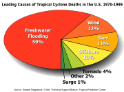
- Storm surge - Tropical cyclones cause an increase in sea level, which can flood coastal communities. This is the worst effect, as historically cyclones claimed 80% of their victims when they first strike shore.
- Heavy rain - The thunderstorm activity in a tropical cyclone causes intense rainfall. Rivers and streams flood, roads become impassable, and landslides can occur. Inland areas are particularly vulnerable to freshwater flooding, due to residents not preparing adequately.
- Tornado activity - The broad rotation of a hurricane often spawns tornadoes. Also, tornadoes can be spawned as a result of eyewall mesovortices, which persist until landfall. While these tornadoes are normally not as strong as their non-tropical counterparts, they can still cause tremendous damage.
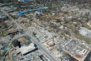
Often, the secondary effects of a tropical cyclone are equally damaging. These include:
- Disease - The wet environment in the aftermath of a tropical cyclone, combined with the destruction of sanitation facilities and a warm tropical climate, can induce epidemics of disease which claim lives long after the storm passes. One of the most common post-hurricane injuries is stepping on a nail in storm debris, leading to a risk of tetanus or other infection. Infections of cuts and bruises can be greatly amplified by wading in sewage- polluted water. Large areas of standing water caused by flooding also contribute to mosquito-borne illnesses.
- Power outages - Tropical cyclones often knock out power to tens or hundreds of thousands of people (or occasionally millions if a large urban area is affected), prohibiting vital communication and hampering rescue efforts.
- Transportation difficulties - Tropical cyclones often destroy key bridges, overpasses, and roads, complicating efforts to transport food, clean water, and medicine to the areas that need it.
Beneficial effects of tropical cyclones
Although cyclones take an enormous toll in lives and personal property, they may be important factors in the precipitation regimes of places they impact and bring much-needed precipitation to otherwise dry regions. Hurricanes in the eastern north Pacific often supply moisture to the Southwestern United States and parts of Mexico. Japan receives over half of its rainfall from typhoons. Hurricane Camille averted drought conditions and ended water deficits along much of its path, though it also killed 259 people and caused $9.14 billion (2005 USD) in damage.
Hurricanes also help to maintain global heat balance by moving warm, moist tropical air to the mid-latitudes and polar regions. Were it not for the movement of heat poleward (through other means as well as hurricanes), the tropical regions would be unbearably hot. The storm surges and winds of hurricanes may be destructive to human-made structures, but they also stir up the waters of coastal estuaries, which are typically important fish breeding locales.
In addition, the destruction caused by Camille on the Gulf coast spurred redevelopment as well, greatly increasing local property values. On the other hand, disaster response officials point out that redevelopment encourages more people to live in clearly dangerous areas subject to future deadly storms. Hurricane Katrina is the most obvious example, as it devastated the region that had been revitalized after Hurricane Camille. Of course, many former residents and businesses do relocate to inland areas away from the threat of future hurricanes as well.
At sea, tropical cyclones can stir up water, leaving a cool wake behind them. This can cause the region to be less favourable for a subsequent tropical cyclone. On rare occasions, tropical cyclones may actually do the opposite. 2005's Hurricane Dennis blew warm water behind it, contributing to the unprecedented intensity of the close-following Hurricane Emily.
Long term trends in cyclone activity
While the number of storms in the Atlantic has increased since 1995, there seems to be no signs of a numerical global trend; the annual global number of tropical cyclones remains about 90 ± 10. However, there is some evidence that the intensity of hurricanes is increasing. "Records of hurricane activity worldwide show an upswing of both the maximum wind speed in and the duration of hurricanes. The energy released by the average hurricane (again considering all hurricanes worldwide) seems to have increased by around 70% in the past 30 years or so, corresponding to about a 15% increase in the maximum wind speed and a 60% increase in storm lifetime."
Atlantic storms are certainly becoming more destructive financially, since five of the ten most expensive storms in United States history have occurred since 1990. This can be attributed to the increased intensity and duration of hurricanes striking North America and to the number of people living in susceptible coastal area following increased development in the region since the last surge in Atlantic hurricane activity in the 1960s.
Often in part because of the threat of hurricanes, many coastal regions had sparse population between major ports until the advent of automobile tourism; therefore, the most severe portions of hurricanes striking the coast may have gone unmeasured in some instances. The combined effects of ship destruction and remote landfall severely limit the number of intense hurricanes in the official record before the era of hurricane reconnaissance aircraft and satellite meteorology. Although the record shows a distinct increase in the number and strength of intense hurricanes, therefore, experts regard the early data as suspect.
The number and strength of Atlantic hurricanes may undergo a 50-70 year cycle. Although more common since 1995, few above-normal hurricane seasons occurred during 1970-1994. Destructive hurricanes struck frequently from 1926-60, including many major New England hurricanes. A record 21 Atlantic tropical storms formed in 1933, only recently exceeded in 2005. Tropical hurricanes occurred infrequently during the seasons of 1900-1925; however, many intense storms formed 1870-1899. During the 1887 season, 19 tropical storms formed, of which a record 4 occurred after 1 November and 11 strengthened into hurricanes. Few hurricanes occurred in the 1840s to 1860s; however, many struck in the early 1800s, including an 1821 storm that made a direct hit on New York City, which some historical weather experts say may have been as high as Category 4 in strength.
These unusually active hurricane seasons predated satellite coverage of the Atlantic basin that now enables forecasters to see all tropical cyclones. Before the satellite era began in 1961, tropical storms or hurricanes went undetected unless a ship reported a voyage through the storm. The official record, therefore, could miss storms in which no ship experienced gale-force winds, recognized it as a tropical storm (as opposed to a high-latitude extra-tropical cyclone, a tropical wave, or a brief squall), returned to port, and reported the experience.
Global warming
A common question is whether global warming can or will cause more frequent or more fierce tropical cyclones. So far, virtually all climatologists seem to agree that a single storm, or even a single season, cannot clearly be attributed to a single cause such as global warming or natural variation. The question is thus whether a statistical trend in frequency or strength of cyclones exists. The U.S. National Oceanic and Atmospheric Administration Geophysical Fluid Dynamics Laboratory performed a simulation that concluded "the strongest hurricanes in the present climate may be upstaged by even more intense hurricanes over the next century as the earth's climate is warmed by increasing levels of greenhouse gases in the atmosphere." .
In an article in Nature, Kerry Emanuel states that the potential hurricane destructiveness, a measure which combines strength, duration, and frequency of hurricanes, "is highly correlated with tropical sea surface temperature, reflecting well-documented climate signals, including multidecadal oscillations in the North Atlantic and North Pacific, and global warming." K. Emanuel further predicts "a substantial increase in hurricane-related losses in the twenty-first century."
Along similar lines, P.J. Webster and others published an article in Science examining "changes in tropical cyclone number, duration, and intensity" over the last 35 years, a period where satellite data is available. The main finding is that while the number of cyclones "decreased in all basins except the North Atlantic during the past decade" there is a "large increase in the number and proportion of hurricanes reaching categories 4 and 5." That is, while the number of cyclones decreased overall, the number of very strong cyclones increased.
Both Emanuel and Webster et al., consider the sea surface temperature as of key importance in the development of cyclones. The question then becomes: what caused the observed increase in sea surface temperatures? In the Atlantic, it could be due to global warming and the hypothesized Atlantic Multidecadal Oscillation (AMO), a possible 50–70 year pattern of temperature variability. Emanuel, however, found the recent temperature increase was outside the range of previous sea surface temperature peaks. So, both global warming and a natural variation (such as the AMO) could have made contributions to the warming of the tropical Atlantic over the past decades, but an exact attribution is so far impossible to make.
While Emanuel analyzes total annual energy dissipation, Webster et al. analyze the percentage of hurricanes in the combined categories 4 and 5, and find that this percentage has increased in each of six distinct hurricane basins: North Atlantic, North East and North West Pacific, South Pacific, and North and South Indian.
Under the assumption that the six basins are statistically independent except for the effect of global warming, has carried out the obvious paired t-test and found that the null-hypothesis of no impact of global warming on the percentage of Category 4 and 5 hurricanes can be rejected at the 0.1% level. Thus, there is only a 1 in 1000 chance of simultaneously finding the observed six increases in the percentages of Category 4 or 5 hurricanes. This statistic needs refining because the variables being tested are not normally distributed with equal variances, but it may provide the best evidence yet that the impact of global warming on hurricane intensity has been detected.
Observation and forecasting
Observation
Intense tropical cyclones pose a particular observation challenge. As they are a dangerous oceanic phenomenon, weather stations are rarely available on the site of the storm itself. Surface level observations are generally available only if the storm is passing over an island or a coastal area, or if it has overtaken an unfortunate ship. Even in these cases, real-time measurements are generally possible only in the periphery of the cyclone, where conditions are less catastrophic.
It is however possible to take in-situ measurements, in real-time, by sending specially equipped reconnaissance flights into the cyclone. In the Atlantic basin, these flights are regularly flown by United States government hurricane hunters. The aircraft used are WC-130 Hercules and WP-3D Orions, both four-engine turboprop cargo aircraft. These aircraft fly directly into the cyclone and take direct and remote-sensing measurements. The aircraft also launch GPS dropsondes inside the cyclone. These sondes measure temperature, humidity, pressure, and especially winds between flight level and the ocean's surface.
A new era in hurricane observation began when a remotely piloted Aerosonde, a small drone aircraft, was flown through Tropical Storm Ophelia as it passed Virginia's Eastern Shore during the 2005 hurricane season. This demonstrated a new way to probe the storms at low altitudes that human pilots seldom dare.
Tropical cyclones far from land are tracked by weather satellites capturing visible and infrared images from space, usually at half-hour to quarter-hour intervals. As a storm approaches land, it can be observed by land-based Doppler radar. Radar plays a crucial role around landfall because it shows a storm's location and intensity minute by minute.
Recently, academic researchers have begun to deploy mobile weather stations fortified to withstand hurricane-force winds. The two largest programs are the Florida Coastal Monitoring Program and the Wind Engineering Mobile Instrumented Tower Experiment. During landfall, the NOAA Hurricane Research Division compares and verifies data from reconnaissance aircraft, including wind speed data taken at flight level and from GPS dropwindsondes and stepped-frequency microwave radiometers, to wind speed data transmitted in real time from weather stations erected near or at the coast. The National Hurricane Centre uses the data to evaluate conditions at landfall and to verify forecasts.
Forecasting
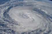
Because of the forces that affect tropical cyclone tracks, accurate track predictions depend on determining the position and strength of high- and low-pressure areas, and predicting how those areas will change during the life of a tropical system.
With their understanding of the forces that act on tropical cyclones, and a wealth of data from earth-orbiting satellites and other sensors, scientists have increased the accuracy of track forecasts over recent decades. High-speed computers and sophisticated simulation software allow forecasters to produce computer models that forecast tropical cyclone tracks based on the future position and strength of high- and low-pressure systems. But while track forecasts have become more accurate than 20 years ago, scientists say they are less skillful at predicting the intensity of tropical cyclones. They attribute the lack of improvement in intensity forecasting to the complexity of tropical systems and an incomplete understanding of factors that affect their development.
Classifications, Terminology and Naming
Intensity classifications

Tropical cyclones are classified into three main groups, based on intensity: tropical depressions, tropical storms, and a third group of more intense storms, whose name depends on the region.
A tropical depression is an organized system of clouds and thunderstorms with a defined surface circulation and maximum sustained winds of less than 17 m/s (33 kt, 38 mph, or 62 km/h). It has no eye, and does not typically have the organization or the spiral shape of more powerful storms. It is already a low-pressure system, however, hence the name "depression." The Philippines will name tropical depressions from their own naming convention within their sphere of influence.
A tropical storm is an organized system of strong thunderstorms with a defined surface circulation and maximum sustained winds between 17 and 32 m/s (34–63 kt, 39–73 mph, or 62–117 km/h). At this point, the distinctive cyclonic shape starts to develop, though an eye is usually not present. Government weather services, outside of the Philippines, assign first names to systems that reach this intensity (thus the term named storm).
A hurricane or typhoon (sometimes simply referred to as a tropical cyclone, as opposed to a depression or storm) is a system with sustained winds greater than 33 m/s (64 kt, 74 mph, or 118 km/h). A tropical cyclone tends to develop an eye, an area of relative calm (and lowest atmospheric pressure) at the center of circulation. The eye is often visible in satellite images as a small, circular, cloud-free spot. Surrounding the eye is the eyewall, an area about 10–50 mi (16–80 km) wide in which the strongest thunderstorms and winds circulate around the storm's centre.
The circulation of clouds around a cyclone's centre imparts a distinct spiral shape to the system. Bands or arms may extend over great distances as clouds are drawn toward the cyclone. The direction of the cyclonic circulation depends on the hemisphere; it is counterclockwise in the Northern Hemisphere and clockwise in the Southern Hemisphere. Maximum sustained winds in the strongest tropical cyclones have been measured at more than 85 m/s (165 kt, 190 mph, 305 km/h). Intense, mature hurricanes can sometimes exhibit an inward curving of the eyewall top that resembles a football stadium: this phenomenon is thus sometimes referred to as the stadium effect.
Eyewall replacement cycles naturally occur in intense tropical cyclones. When cyclones reach peak intensity they usually - but not always - have an eyewall and radius of maximum winds that contract to a very small size, around 5 to 15 miles. At this point, some of the outer rainbands may organize into an outer ring of thunderstorms that slowly moves inward and robs the inner eyewall of its needed moisture and momentum. During this phase, the tropical cyclone is weakening (i.e.,... the maximum winds die off a bit and the central pressure goes up). Eventually the outer eyewall replaces the inner one completely and the storm can be the same intensity as it was previously or, in some cases, even stronger. Even if the cyclone is weaker at the end of the eyewall replacement cycle, the fact that it has just undergone one and will not undergo another one soon will allow it to strengthen further, if other conditions allow it to do so.
Categories and ranking
| Saffir-Simpson Hurricane Scale | ||||||
| TD | TS | 1 | 2 | 3 | 4 | 5 |
Hurricanes are ranked according to their maximum winds using the Saffir-Simpson Hurricane Scale. A Category 1 storm has the lowest maximum winds (74-95 mph, 119-153 km/h), a Category 5 hurricane has the highest (> 155 mph, 249 km/h). The U.S. National Hurricane Centre classifies hurricanes of Category 3 and above as major hurricanes.
The U.S. Joint Typhoon Warning Centre classifies West Pacific typhoons as tropical cyclones with winds greater than 73 mph (118 km/h). Typhoons with wind speeds of at least 150 mph (67 m/s or 241 km/h, equivalent to a strong Category 4 hurricane) are dubbed Super Typhoons.
The Australian Bureau of Meteorology uses a 1-5 scale called tropical cyclone severity categories. Unlike the Saffir-Simpson Hurricane Scale, severity categories are based on estimated maximum wind gusts. A category 1 storm features gusts less than 126 km/h (78 mph), while gusts in a category 5 cyclone are at least 280 km/h (174 mph).
Meteorologists in the United States use maximum 1-minute average sustained winds 10 meters above the ground to determine tropical cyclone strength. Other countries use the maximum 10-minute average, as suggested by the World Meteorological Organization. Maximum wind speeds are typically about 12% lower with the 10-minute method than with the 1-minute method.
The rankings are not absolute in terms of damage and other effects, since it only based on windspeed. Lower-category storms can inflict greater damage than higher-category storms, depending on factors such as local terrain and total rainfall. For instance, a Category 2 hurricane that strikes a major urban area will likely do more damage than a large Category 5 hurricane that strikes a mostly rural region. In fact, tropical systems of minimal strength can produce significant damage and human casualties from flooding and landslides, particularly if they are slow-moving or very large in size.
Regional terminology
Depending on their current basin and intensity, tropical cyclones may be referred to using one of many different terms, and each basin uses a separate system of terminology, making comparison difficult. Tropical cyclones which cross from one basin into another may then be referred to as a tropical cyclone of the type in the new basin rather than its original basin. This, however, is only common in the Pacific Ocean, where hurricanes from the Central North Pacific sometimes cross into the Northwest Pacific and are called typhoons. On very rare occasions, a typhoon will cross into the Central Pacific and become known as a hurricane. No other types of basin crossings that would result in a change of term have been recorded. Additionally, most basins use a 10-minute average of sustained wind speeds to determine intensity, as recommended by the WMO, but this is not the case in the North Atlantic and Northeastern Pacific, where 1-minute averages, almost always higher, are used.
In the North Atlantic and Northeastern Pacific, as well as the Central North Pacific, tropical cyclones with sustained winds of less than 39 miles per hour (63 km/h) are referred as tropical depressions. If a tropical system acquires wind speeds of 39 miles per hour or greater, it becomes a tropical storm. Tropical storms which attain wind speeds of 74 miles per hour (119 km/h) or higher, or hurricane-force on the Beaufort wind scale, are then referred to as hurricanes. All measurements in the North Atlantic, Northeastern Pacific and North Central pacific use 1-minute average sustained wind speeds.
In the Northwestern Pacific, tropical cyclones with sustained winds of less than 63 kilometres per hour (39 mph) are referred to as tropical depressions, as in the North Atlantic, Northeastern Pacific and Central Pacific, though measurements are made using 10-minute averages for sustained winds. Tropical systems with sustained winds that reach 63 kilometres per hour (39 mph) are called tropical storms, again using the same terminology, but if a tropical storm in the Northwestern Pacific reaches sustained winds of 89 kilometres per hour (55 mph), it becomes referred to as a severe tropical storm. Systems that have sustained winds measured at hurricane-strength on the Beaufort scale are referred to as typhoons. It is also of note that typhoons with sustained winds greater than 239 kilometres per hour (150 mph) are called super typhoons by Joint Typhoon Warning Centre. This term is not defunct in official usage in WMO typhoon committee, both before and after 2000.
In the Southwestern Indian Ocean: (1) a "tropical depression" is a tropical disturbance in which the maximum of the average wind speed is 28 to 33 knots (51 to 62 km/h); (2) a "moderate tropical storm" is a tropical disturbance in which the maximum of the average wind speed is 34 to 47 knots (63 to 88 km/h); (3) a "severe tropical storm" is a tropical disturbance in which the maximum of the average wind speed is 48 to 63 knots (89 to 117 km/h); (4) a "tropical cyclone" is a tropical disturbance in which the maximum of the average wind speed is 64 to 89 knots (118 to 165 km/h); (5) an "intense tropical cyclone" is a tropical disturbance in which the maximum of the average wind speed is 90 to 115 knots (166 to 212 km/h); and (6) a "very intense tropical cyclone" is a tropical disturbance in which the maximum of the average wind speed is greater than 115 knots (greater than 212 km/h).
There are many regional names for tropical cyclones, including † baguio and spelt in the vernacular, bagyo in the Philippines and Taino in Haiti.
Origin of storm terms
- The word typhoon has two possible origins:
- From the Chinese 大風 (daaih fūng ( Cantonese); dà fēng ( Mandarin)) which means "great wind." (The Chinese term as 颱風 táifēng, and 台風 taifū in Japanese, has an independent origin traceable variously to 風颱, 風篩 or 風癡 hongthai, going back to Song 宋 (960-1278) and Yuan 元(1260-1341) dynasties. The first record of the character 颱 appeared in 1685's edition of Summary of Taiwan 臺灣記略).
- From Urdu, Persian or Arabic ţūfān (طوفان) < Greek tuphōn (Τυφών).
- Portuguese tufão is also related to typhoon. See Typhon for more information.
- The word hurricane is derived from the name of a native Caribbean Amerindian storm god, Huracan, via Spanish huracán.
- The word cyclone was coined by a Captain Henry Piddington, who used it to refer to the storm that blew a freighter in circles in Mauritius in February of 1845. Tropical cyclones are then circular wind storms that form in the tropics.
Naming of tropical cyclones
Storms reaching tropical storm strength are given names, to assist in recording insurance claims, to assist in warning people of the coming storm, and to further indicate that these are important storms that should not be ignored. These names are taken from lists which vary from region to region and are drafted a few years ahead of time. The lists are decided upon, depending on the regions, either by committees of the World Meteorological Organization (called primarily to discuss many other issues), or by national weather offices involved in the forecasting of the storms.
Each year, the names of particularly destructive storms (if there are any) are "retired" and new names are chosen to take their place.
Naming schemes
In the North Atlantic and Northeastern Pacific regions, feminine and masculine names are alternated in alphabetic order during a given season. The gender of the season's first storm also alternates year to year. Six lists of names are prepared in advance, and each list is used once every six years. Five letters — "Q," "U," "X," "Y" and "Z" — are omitted in the North Atlantic; only "Q" and "U" are omitted in the Northeastern Pacific. This allows for 21 names in the North Atlantic and 24 names in Northeastern Pacific. Names of storms may be retired by request of affected countries if they have caused extensive damage. The affected countries then decide on a replacement name of the same gender, and if possible, the same language as the name being retired. If there are more than 21 named storms in an Atlantic season or 24 named storms in an Eastern Pacific season, the rest are named as letters from the Greek alphabet. This was first necessary during the 2005 Atlantic season when the list was exhausted. There is no precedent for a storm named with a Greek letter causing enough damage to justify retirement; how this situation would be handled is unknown.
In the Central North Pacific region, the name lists are maintained by the Central Pacific Hurricane Centre in Honolulu, Hawaii. Four lists of Hawaiian names are selected and used in sequential order without regard to year.
In the Northwestern Pacific, name lists are maintained by the WMO Typhoon Committee. Five lists of names are used, with each of the 14 nations on the Typhoon Committee submitting two names to each list. Names are used in the order of the countries' English names, sequentially without regard to year. Since 1981, the numbering system had been the primary system to identify tropical cyclone among Typhoon Committee members and it is still in use. International numbers are assigned by Japan Meteorological Agency on the order that a tropical storm forms while different internal numbers may be assigned by different NMCs. The Typhoon "Songda" in September 2004 was internally called the typhoon number 18 in Japan but typhoon number 19 in China. Internationally, it is recorded as the TY Sonda (0418) with "04" taken from the year. Names are retired from the lists upon request. The most common reason is to memorize the extensive damage caused by the storm. When names are retired, the contributing member should propose new names. A possible way to do so is through local name nomination contest, which was done in Hong Kong and China.
The Australian Bureau of Meteorology maintains three lists of names, one for each of the Western, Northern and Eastern Australian regions. These lists are in alphabetical order and alternate gender, but are used sequentially rather than switched each year. There are also Fiji region and Papua New Guinea region names agreed upon WMO RA V Tropical Cyclone Committee members.
The RA I Tropical Cyclone Committee for the South-West Indian Ocean creates the lists of names for the Southwestern Indian Ocean. The committee adopted two separate lists of names for the 2006-07 and 2007-08 tropical cyclone seasons at its October 2005 meeting in Gaborone, Botswana. Nominations for the lists were submitted by Mauritius, Malawi, Mozambique, Namibia, Seychelles, South Africa, Swaziland, Zimbabwe, Tanzania, Botswana, Comoros, Lesotho, and Madagascar. If a tropical disturbance reaches "moderate tropical storm" status west of 55 degrees east longitude, then the Sub-regional Tropical Cyclone Advisory Centre in Madagascar assigns the appropriate name to the storm. If a tropical disturbance reaches "moderate tropical storm" status between 55 and 90 degrees east longitude, then the Sub-regional Tropical Cyclone Advisory Centre in Mauritius assigns the appropriate name to the storm.
Renaming of tropical cyclones
In most cases, a tropical cyclone retains its name throughout its life. However, a tropical cyclone may be renamed in several occasions.
- A tropical storm enters the southwestern Indian Ocean from the east
- In the southwestern Indian Ocean, Météo-France in Réunion names a tropical storm once it crosses 90°E from the east, even though it has been named. In this case, the Joint Typhoon Warning Centre (JTWC) will put two names together with a hyphen. Examples include Cyclone Adeline-Juliet in early 2005 and Cyclone Bertie-Alvin in late 2005.
- A tropical storm crosses from the Atlantic into the Pacific, or vice versa, before 2001
- It was the policy of National Hurricane Centre (NHC) to rename a tropical storm which crossed from Atlantic into Pacific, or vice versa. Examples include Hurricane Cesar-Douglas in 1996 and Hurricane Joan-Miriam in 1988.
- In 2001, when Iris moved across Central America, NHC mentioned that Iris would retain its name if it regenerated in the Pacific. However, the Pacific tropical depression developed from the remnants of Iris was called Fifteen-E instead. The depression later became tropical storm Manuel.
- NHC explained that Iris had dissipated as a tropical cyclone prior to entering the eastern North Pacific basin; the new depression was properly named Fifteen-E, rather than Iris.
- In 2003, when Larry was about to move across Mexico, NHC attempted to provide greater clarity:
- "Should Larry remain a tropical cyclone during its passage over Mexico into the Pacific, it would retain its name. However, a new name would be given if the surface circulation dissipates and then regenerates in the Pacific."
- Up to now, there has been no tropical cyclone retaining its name during the passage from Atlantic to Pacific, or vice versa.
- In 2001, when Iris moved across Central America, NHC mentioned that Iris would retain its name if it regenerated in the Pacific. However, the Pacific tropical depression developed from the remnants of Iris was called Fifteen-E instead. The depression later became tropical storm Manuel.
- It was the policy of National Hurricane Centre (NHC) to rename a tropical storm which crossed from Atlantic into Pacific, or vice versa. Examples include Hurricane Cesar-Douglas in 1996 and Hurricane Joan-Miriam in 1988.
- Uncertainties of the continuation
- When the remnants of a tropical cyclone redevelop, the redeveloping system will be treated as a new tropical cyclone if there are uncertainties of the continuation, even though the original system may contribute to the forming of the new system. One example is Tropical Depression 10-Tropical Depression 12 (which became Hurricane Katrina) from 2005.
- Human errors
- Sometimes, there may be human faults leading to the renaming of a tropical cyclone. This is especially true if the system is poorly organized or if it passes from the area of responsibility of one forecaster to another. Examples include Tropical Storm Ken-Lola in 1989 and Tropical Storm Upana-Chanchu in 2000
History of tropical cyclone naming
For several hundred years after Europeans arrived in the West Indies, hurricanes there were named after the saint's day on which the storm struck. If a second storm struck on the same saint's day later, it would be referred to as segundo (Spanish for "the second"), as with Hurricane San Felipe Segundo.
The practice of giving storms people's names was introduced by Clement Lindley Wragge, an Anglo-Australian meteorologist at the end of the 19th century. He used girls' names, the names of politicians who had offended him, and names from history and mythology.
During World War II, tropical cyclones were given feminine names, mainly for the convenience of the forecasters and in a somewhat ad hoc manner. In addition, George R. Stewart's 1941 novel Storm helped to popularize the concept of giving names to tropical cyclones.
From 1950 to 1954, names from the Joint Army/Navy Phonetic Alphabet were used for storms in the North Atlantic. The modern naming convention came about in response to the need for unambiguous radio communications with ships and aircraft. As transportation traffic increased and meteorological observations improved in number and quality, several typhoons, hurricanes or cyclones might have to be tracked at any given time. To help in their identification, beginning in 1953 the practice of systematically naming tropical storms and hurricanes was initiated by the United States National Hurricane Centre. Naming is now maintained by the World Meteorological Organization.
In keeping with the common English language practice of referring to named inanimate objects such as boats, trains, etc., using the female pronoun "she," names used were exclusively feminine. The first storm of the year was assigned a name beginning with the letter "A", the second with the letter "B", etc. However, since tropical storms and hurricanes are primarily destructive, some considered this practice sexist. The World Meteorological Organization responded to these concerns in 1979 with the introduction of masculine names to the nomenclature. It was also in 1979 that the practice of preparing a list of names before the season began. The names are usually of English, French or Spanish origin in the Atlantic basin, since these are the three predominant languages of the region which the storms typically affect. In the southern hemisphere, male names were given to cyclones starting in 1975.
Notable cyclones
Tropical cyclones that cause massive destruction are fortunately rare, but when they happen, they can cause damage in the range of billions of dollars and disrupt or end thousands of lives.
The deadliest tropical cyclone on record hit the densely populated Ganges Delta region of Bangladesh on November 13, 1970, likely as a Category 3 tropical cyclone. It killed an estimated 500,000 people. The North Indian basin has historically been the deadliest, with several storms since 1900 killing over 100,000 people, each in Bangladesh.
In the Atlantic basin, at least three storms have killed more than 10,000 people. Hurricane Mitch during the 1998 Atlantic hurricane season caused severe flooding and mudslides in Honduras, killing about 18,000 people and changing the landscape enough that entirely new maps of the country were needed. The Galveston Hurricane of 1900, which made landfall at Galveston, Texas as an estimated Category 4 storm, killed 8,000 to 12,000 people, and remains the deadliest natural disaster in the history of the United States. The deadliest Atlantic storm on record was the Great Hurricane of 1780, which killed about 22,000 people in the Antilles.
The most intense storm on record was Typhoon Tip in the northwestern Pacific Ocean in 1979, which had a minimum pressure of only 870 mbar and maximum sustained wind speeds of 190 mph (305 km/h). It weakened before striking Japan. Tip does not hold the record for fastest sustained winds in a cyclone alone; Typhoon Keith in the Pacific, and Hurricane Camille and Hurricane Allen in the North Atlantic currently share this record as well, although recorded wind speeds that fast are suspect since most monitoring equipment is likely to be destroyed by such extreme conditions. Camille was the only storm to actually strike land while at that intensity, making it, with 190 mph (305 km/h) sustained winds and 210 mph (335 km/h) gusts, the strongest tropical cyclone on record at landfall. For comparison, these speeds are encountered at the centre of a strong tornado, but Camille, like all tropical cyclones, was much larger and long-lived than any tornado.
Typhoon Nancy in 1961 had recorded wind speeds of 215 mph (345 km/h), but recent research indicates that wind speeds from the 1940s to the 1960s were gauged too high, and this is no longer considered the fastest storm on record. Similarly, a surface-level gust caused by Typhoon Paka on Guam was recorded at 236 mph (380 km/h); had it been confirmed, this would be the strongest non-tornadic wind ever recorded at the Earth's surface, but the reading had to be discarded since the anemometer was damaged by the storm.
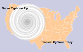
Tip was also the largest cyclone on record, with a circulation of tropical storm-force winds 1,350 miles (2,170 km) wide. The average tropical cyclone is only 300 miles (480 km) wide. The smallest storm on record, 1974's Cyclone Tracy, which devastated Darwin, Australia, was roughly 60 miles (100 km) wide.
Hurricane Iniki in 1992 was the most powerful storm to strike Hawaii in recorded history, hitting Kauai as a Category 4 hurricane, killing six and causing $3 billion in damage. Other destructive Pacific hurricanes include Pauline and Kenna.
On March 26, 2004, Cyclone Catarina became the first recorded South Atlantic cyclone (cyclone is the southern hemispheric term for hurricane). Previous South Atlantic cyclones in 1991 and 2004 reached only tropical storm strength. Tropical cyclones may have formed there before 1960 but were not observed until weather satellites began monitoring the Earth's oceans in that year.
A tropical cyclone need not be particularly strong to cause memorable damage; Tropical Storm Thelma, in November 1991 killed thousands in the Philippines even though it never became a typhoon; the damage from Thelma was mostly due to flooding, not winds or storm surge. In 1982, the unnamed tropical depression that eventually became Hurricane Paul caused the deaths of around 1,000 people in Central America due to the effects of its rainfall. In addition, Hurricane Jeanne in 2004 caused the majority of its damage in Haiti, including approximately 3,000 deaths, while just a tropical depression.
On August 29, 2005, Hurricane Katrina made landfall in Louisiana and Mississippi. The U.S. National Hurricane Centre, in its August review of the tropical storm season stated that Katrina was probably the worst natural disaster in U.S. history. Currently, its death toll is at least 1,836, mainly from flooding and the aftermath in New Orleans, Louisiana and the Mississippi Gulf Coast. It is also estimated to have caused $81.2 billion in property damage. Before Katrina, the costliest system in monetary terms had been 1992's Hurricane Andrew, which caused an estimated $39 billion (2005 USD) in damage in Florida.
Other storm systems
Many other forms of cyclone can form in nature. Two of these relate to the formation or dissipation of tropical cyclones.
Extratropical cyclone
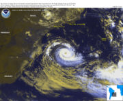
An extratropical cyclone is a storm that derives energy from horizontal temperature differences, which are typical in higher latitudes. A tropical cyclone can become extratropical as it moves toward higher latitudes if its energy source changes from heat released by condensation to differences in temperature between air masses; Additionally, although not as frequently, an extratropical cyclone can transform into a subtropical storm, and from there into a tropical cyclone. From space, extratropical storms have a characteristic " comma-shaped" cloud pattern. Extratropical cyclones can also be dangerous because their low-pressure centers cause powerful winds.
Subtropical cyclone
A subtropical cyclone is a weather system that has some characteristics of a tropical cyclone and some characteristics of an extratropical cyclone. They can form in a wide band of latitude, from the equator to 50°. Although subtropical storms rarely attain hurricane-force winds, they may become tropical in nature as their core warms. From an operational standpoint, a tropical cyclone is usually not considered to become subtropical during its extratropical transition.
