Tornado
2007 Schools Wikipedia Selection. Related subjects: Climate and the Weather
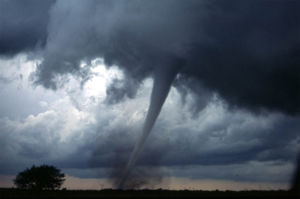
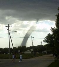
A tornado is a violently rotating column of air which is in contact with both a cumulonimbus (or, in rare cases, cumulus) cloud base and the surface of the earth. Tornadoes can come in many shapes, but are typically in the form of a visible condensation funnel, with the narrow end touching the earth. Often, a cloud of debris encircles the lower portion of the funnel.
Most have winds of 110 mph (175 km/h) or less, are approximately 250 feet (75 meters) across, and travel a few miles (several kilometers) before dissipating. However, some tornadoes can have winds of more than 300 mph (480 km/h), be more than a mile (1.6 km) across, and stay on the ground for dozens of miles (more than 100 kilometers).
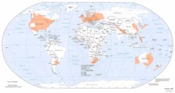
They have been observed on every continent except Antarctica; however, a significant percentage of the world's tornadoes occur in the United States. This is mostly due to the unique geography of the country, which allows the conditions which breed strong, long-lived storms to occur many times a year. Other areas which commonly experience tornadoes include New Zealand, western and southeastern Australia, south-central Canada, northwestern Europe, Italy, south-central and eastern Asia, east-central South America, and Southern Africa.
Etymology
The word "tornado" is an altered form of the Spanish word tronada, which means "thunderstorm". This in turn was taken from the Latin tonare, meaning "to thunder". It most likely reached its present form through a combination of the Spanish tronada and tornar ("to turn"); however, this may be a folk etymology.
Some common, related slang terms include: twister, whirlwind, cyclone, funnel, wedge, tube, finger of God, Devil's tail, rope, or stovepipe.
Definitions
A tornado is defined by the Glossary of Meteorology as "a violently rotating column of air, in contact with the ground, either pendant from a cumuliform cloud or underneath a cumuliform cloud, and often (but not always) visible as a funnel cloud.." A tornado does not necessarily have to be visible; however, the low pressures caused by the fast wind speeds (see Bernoulli's principle) usually cause water vapor in the air to condense into a visible condensation funnel. Strictly, the term tornado refers to the vortex of wind, connecting to both the surface and a convective cloud above, not the condensation cloud.
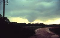
A funnel cloud is a low-hanging, vertically rotating cloud, with no associated strong winds at the surface. Funnel clouds are not tornadoes, and not all funnel clouds develop into a tornado. However, many tornadoes are preceded by a funnel cloud aloft in which condensation descends from the parent storm as saturation occurs at progressively lower altitude. It is often difficult to tell the difference between a funnel cloud and a tornado from a distance. Most tornadoes produce strong winds at the surface while the visible funnel is still a good distance from the ground. This is usually marked by swirling dust and debris at the surface, confirming a tornadic circulation is on the ground. A shear funnel is a tiny, harmless funnel which occasionally forms underneath or on the sides of cumuliform clouds.
Tornadoes commonly develop from a class of thunderstorms known as supercells. Supercells contain mesocyclones, in which rotation is organized. Most intense tornadoes (F3 to F5 on the Fujita Scale) develop from supercells. Very heavy rain, frequent lightning, strong wind gusts, and hail are also common in such storms. The largest hail generally comes from supercells, as a very strong and rotating updraft is usually required to suspend such large hailstones aloft.
Stronger tornadoes are also those most observed to have multiple vortices (or, subvortices) which are many columns of violently spinning air rotating around a common centre. Multivortex structure occurs in smaller tornadoes as well as other circulations. A satellite tornado is a term for a weaker tornado which forms very near a large, strong tornado, contained within the same mesocyclone. The satellite tornado may appear to " orbit" the larger tornado (hence the name), giving the appearance of one, large multi-vortex tornado. However, a satellite tornado is a distinct funnel, and is much smaller than the main funnel.. Occasionally a single storm may produce multiple different tornadoes and mesocyclones, this process is known as cyclic tornadoegenesis. Tornadoes produced from the same storm constitute a tornado family . An anticyclonic tornado rotates clockwise in the Northern Hemisphere and counterclockwise in the Southern Hemisphere.
Occasionally, many tornadoes are spawned from the same general storm system. While there is no single agreed upon definition, multiple tornadoes spawned by the same general storm system with no break in activity for 6 to 24 hours (depending on definition in use) is considered a tornado outbreak. The qualifying numbers vary, currently for the United States, about ten tornadoes constitutes an outbreak. When there is a break of activity for more than 6 to 24 hours, it usually is considered a separate outbreak. If spawned from the same general system, it may be referred to as an extended tornado outbreak. A period, of at least several successive days, of continuous or near continuous very high tornado activity consisting of a series of tornado outbreaks (spawned by multiple weather systems) is a tornado outbreak sequence, or sometimes, an extended tornado outbreak.
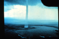
A waterspout is a tornado over water. Although most tornadoes over land are associated with severe thunderstorms, most scientists consider all waterspouts—including "fair weather" waterspouts—to be tornadoes. Although the National Weather Service considers waterspouts as a tornadic meteorological phenomenon, waterspouts are not counted in official records unless they strike land. "Fair weather" waterspouts are less-severe relatives of classic tornadoes and are almost always weak (F0 or F1 on the Fujita Scale), and spawn from non-rotating thunderstorms, or even regular summer showers. Typically, such waterspouts moving onto land cause little or no damage, and dissipate within minutes. However, strong waterspouts from supercells can cause significant damage if they impact land areas. In addition, strong tornadoes can move over lakes or over the ocean, becoming waterspouts, without losing intensity.
A landspout is an unofficial term for a tornado not associated with a mesocyclone. Landspouts most often are weak, featuring a small condensation funnel which often does not appear to reach the ground, and are often marked by a tall tube of dust and/or debris reaching as far up as the parent cloud. Though usually weaker than classic tornadoes, they are tornadoes, and can cause serious damage.
A gustnado is a small, vertical swirl associated with a gust front or downburst. Because they are technically not associated with the cloud base, there is some debate as to whether or not gustnadoes are actually tornadoes. These usually cause localized areas of heavier damage among areas of straight-line wind damage caused by the gust front.
A dust devil is also a vertical swirling column of air. These phenomena resemble tornadoes, but are rarely as strong as even the weakest tornadoes, and form under clear skies. Dust devils are not considered tornadoes because they form during fair weather, and are not associated with convective clouds. However, they can, on occasion, result in major damage and fatalities, especially in arid areas.
Tornado-like circulations occasionally occur near large, intense wildfires and are called fire whirls. They are not generally tornadoes, though are if they connect the surface to a pyrocumulus or other cumuliform cloud above. Fire whirls usually are not as strong as tornadoes associated with thunderstorms, however, they can become quite intense as there are cases of up to F3 damage.
Life cycle
Most tornadoes follow a recognizable life cycle. The cycle begins when a strong thunderstorm develops a rotating mesocyclone a few miles up in the atmosphere, becoming a supercell. As rainfall in the storm increases, it drags with it an area of quickly descending air known as the rear flank downdraft (RFD). This downdraft accelerates as it approaches the ground, and drags the rotating mesocyclone towards the ground with it.
As the mesocyclone approaches the ground, a visible condensation funnel appears to descend from the base of the storm, often from a rotating wall cloud. As the funnel descends, the RFD also reaches the ground, creating a gust front that can cause damage a good distance from the tornado. Usually, the funnel cloud begins causing damage on the ground (becoming a tornado) within minutes of the RFD reaching the ground.
Initially, the tornado has a good source of warm, moist inflow to power it, so it grows until it reaches the mature stage. During its mature stage, which can last anywhere from a few minutes to more than an hour, a tornado often causes the most damage, and can in rare instances be more than one mile across. Meanwhile, the RFD, now an area of cool surface winds, begins to wrap around the tornado, cutting off the inflow of warm air which feeds the tornado.
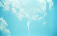
As the RFD completely wraps around and chokes off the tornado's air supply, the tornado begins to weaken, becoming thin and rope-like. This is the dissipating stage, and the tornado often fizzles within minutes. During the dissipating stage, the shape of the tornado becomes highly influenced by the direction of surface winds, and can be blown into fantastic patterns.
As the tornado enters the dissipating stage, its associated mesocyclone often weakens as well, as the rear flank downdraft cuts off the inflow powering it. In particularly intense supercells, tornadoes can develop cyclically. As the first mesocyclone and associated tornado dissipate, the storm's inflow is concentrated into a new area closer to the centre of the storm. If a new mesocyclone develops, the cycle may start again, producing a new tornado. Occasionally, the old, or occluded mesocyclone, and the new mesocyclone produce a tornado at the same time.
Though this is a widely-accepted theory for how most tornadoes form, live, and die, it does not explain the formation of smaller tornadoes, such as landspouts, long-lived tornadoes, or tornadoes with multiple vortices. These each have different mechanisms which influence their development—however, most tornadoes follow a pattern similar to this one.
Characteristics
Shape
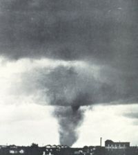
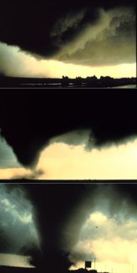
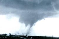
Most tornadoes take on the traditional appearance of a narrow funnel, a few hundred yards across, with a small cloud of debris near the ground. However, tornadoes can appear in all manner of shapes and sizes.
Small, relatively weak landspouts might only be visible as a small swirl of dust on the ground. While the condensation funnel may not extend all the way to the ground, if associated surface winds are greater than 40 mph (64 km/h), it is considered a tornado.
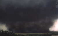
Large single-vortex twisters, often violent, can look like a large wedge stuck into the ground, and are known as wedge tornadoes or wedges. Wedges can be so wide that they appear to be a block of dark clouds. Even experienced storm observers may not be able to tell the difference between a low-hanging cloud and a wedge tornado from a distance.
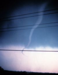
Tornadoes in the dissipating stage can appear like narrow tubes, or ropes, twisting into all manner of curls, twists, and s-shapes. These tornadoes, such as the one pictured at right, are roping out, or becoming a rope tornado. Multiple-vortex tornadoes can appear as a family of swirls circling a common centre, or may be completely obscured by condensation, dust, and debris, appearing to be a single funnel.
In addition to these appearances, tornadoes may be obscured completely by rain or dust. These tornadoes are especially dangerous, as even experienced meteorologists might not spot them.
Size
In the United States, an average tornado is around 500 feet (150 m) across, and stays on the ground for 5 miles (8 km). While this is the average, there is an extremely wide range of tornado sizes, even for typical tornadoes.
Weak tornadoes, or strong but dissipating tornadoes, can be exceedingly narrow, sometimes only a few feet across. In fact, a tornado was once reported to have a damage path only 7 feet (2 m) long.
On the other end of the spectrum, wedge tornadoes can have a damage path a mile (1.6 km) wide or more. A tornado which affected Hallam, Nebraska on May 22, 2004 was at one point 2.5 miles (4 km) wide.
In terms of path length, some meteorologists believe that the Tri-State Tornado, which affected parts of Missouri, Illinois, and Indiana on March 18, 1925, was on the ground continuously for 219 miles (352 km). However, without a modern damage survey, it is impossible to determine whether or not the deadly event was a single tornado or a series of violent tornadoes produced by the same storm. The longest modern-day damage path was caused by a tornado which was on the ground for 160 miles (260 km) in northeastern North Carolina on November 22, 1992.
Appearance
Tornadoes, depending on the environment in which they form, can have a wide range of colors. Tornadoes which form in a dry environment can be nearly invisible, marked only by swirling debris at the base of the funnel. Condensation funnels which pick up little or no debris can be grey to white. While travelling over a body of water as a waterspout, they can turn very white or even blue. Funnels which move slowly, ingesting a lot of debris and dirt, are usually darker, taking on the colour of debris. Tornadoes in the Great Plains can turn red because of the reddish tint of the soil, and tornadoes in mountainous areas can travel over snow-covered ground, turning brilliantly white in the process.
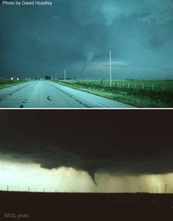
Lighting conditions are also a major factor in the appearance of a tornado. A tornado which is " back-lit", or viewed with the sun behind it, will appear to be very dark. The same tornado, viewed with the sun at the observer's back, may appear grey or brilliant white. Tornadoes which occur near the time of sunset can be many different colors, appearing in hues of yellow, orange, and pink.
Dust kicked up by the winds of the parent thunderstorm, heavy rain and hail, and the darkness of night are all factors which can reduce the visibility of tornadoes, making them "invisible", in essence. Tornadoes occurring in these conditions are especially dangerous, since only radar observations, or possibly the sound of an approaching tornado, serve as any warning to those in the storm's path. Fortunately most significant tornadoes form under the storm's rain-free base, or the area under the thunderstorm's updraft, where there is little or no rain. In addition, most tornadoes occur between the hours of 4 and 8 pm, when the bright sun can penetrate even the thickest clouds. Also, night-time tornadoes are often illuminated by frequent lightning.
There is mounting evidence, including doppler radar images and eyewitness accounts, which suggest that most tornadoes have a clear, calm centre with extremely low pressure, akin to the eye found in tropical cyclones. This area would be clear (possibly full of dust), have relatively light winds, and be very dark, with the light blocked out by swirling debris on the outside of the tornado. Lightning is said to be the source of illumination for those who claim to have seen the interior of a tornado.
Rotation
Tornadoes normally rotate in a cyclonic direction (counterclockwise in the northern hemisphere). Large-scale storms always rotate cyclonically because of the Coriolis effect; however, tornadoes are too small in scale to be directly affected by the rotation of the earth. Approximately 1 tornado in 100 rotates in an anticyclonic direction. Typically, only landspouts and gustnados also rotate anticyclonically. However, on very rare occasions, an anticyclonic supercell can develop, producing a tornado that is typical except for its direction of rotation.
Intensity and damage
Tornadoes vary in intensity regardless of shape, size, and location. While strong tornadoes are typically larger than weak tornadoes, there are several instances of F5 tornadoes with damage paths less than 500 feet (150 m) wide.
History of tornado intensity measurements
For many years, before the advent of home movies and doppler radar, scientists had nothing more than educated guesses as to the speed of the winds in a tornado. The only evidence indicating the wind speeds found in the tornado was the damage left behind by tornadoes which struck populated areas. Some thought they might exceed 500 mph, and perhaps even be supersonic.
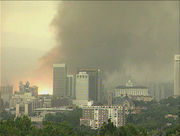
In the 1950s, however, evidence mounted that the actual wind speeds were much lower than this. On April 2, 1957, a slow moving tornado traversed the south and east parts of Dallas, Texas. Before this day, only a few photographs and motion pictures of tornadoes were known to exist. However, because of many factors, including the tornado's high visibility, slow forward motion, and proximity to an urban centre, it became (and still may be) the most filmed and photographed tornado in history. Frame-by-frame analysis of several pieces of footage taken that day showed that the debris flung about by the tornado was travelling at speeds up to 170 mph. Scientists had thought that faster wind speeds would produce the severe damage seen that day, so this tornado gave them their first real clue as to the range of tornado speeds.
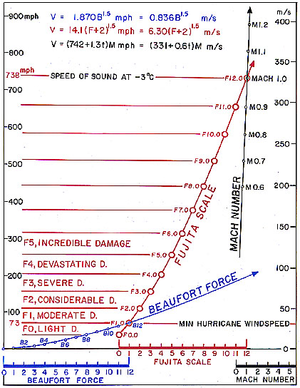
In 1971, Dr. Tetsuya Theodore Fujita introduced the idea for a scale of tornado winds. With the help of colleague Allen Pearson, he created and introduced what came to be called the Fujita scale in 1973. The scale was based on a relationship between the Beaufort scale and the Mach number scale; the low end of F1 on his scale corresponds to the low end of B12 on the Beaufort scale, and the low end of F12 corresponds to the speed of sound at sea level, or Mach 1. In practice, tornadoes are only assigned categories F0 through F5.
The TORRO scale, created by the Tornado and Storm Research Organisation (TORRO), was developed in 1974, and published a year later. The TORRO scale has 12 levels, which cover a broader range with tighter graduations. It ranges from a T0 for extremely weak tornadoes to T11 for the most powerful known tornadoes. T0-T1 roughly correspond to F0, T2-T3 to F1, and so on. While T10+ would be approximately an F5, the highest tornado rated to date on the TORRO scale was a T8. There is some debate as to the usefulness of the TORRO scale over the Fujita scale—while it may be helpful for statistical purposes to have more levels of tornado strength, often the damage caused could be created by a large range of winds, rendering it hard to narrow the tornado down to a single TORRO scale category.
Research conducted in the late 1980s and 1990s suggested that, even with the implication of the Fujita scale, tornado winds were notoriously overestimated, especially in significant and violent tornadoes. Because of this, in 2006, the American Meteorological Society introduced the Enhanced Fujita Scale, to help assign realistic wind speeds to tornado damage. The scientists specifically designed the scale so that a tornado assessed on the Fujita scale and the Enhanced Fujita scale would receive the same ranking. The EF-scale is more specific in detailing the degrees of damage on different types of structures for a given wind speed. While the F-scale goes from F0 to F12 in theory, the EF-scale is capped at EF5, which is defined as "winds ≥ 200 mph (≥ 320 km/h)". In the United States, the Enhanced Fujita scale will be used for tornado damage assessments beginning February 2, 2007.
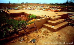
The first observation which confirmed that F5 winds could occur happened on April 26, 1991. A tornado near Red Rock, Oklahoma was monitored by scientists using a portable Doppler radar, an experimental radar device that measures wind speed. Near the tornado's peak intensity, they recorded a wind speed of 115-120 m/s (257-268 mph or 414-432 km/h). Though the portable radar had uncertainty of ± 5-10 m/s (± 11-22 mph or ± 18-36 km/h), this reading was probably within the F5 range, confirming that tornadoes were capable of violent winds found nowhere else on earth.
Eight years later, during the Oklahoma Tornado Outbreak of May 3, 1999, another scientific team was monitoring an exceptionally violent tornado (one which would eventually kill 36 people in the area near Moore, Oklahoma). At about 7 pm, they recorded one measurement of 318 mph , 50 mph faster than the previous record. Though this reading is just short of the theoretical F6 rating, the measurement was taken more than 100 feet in the air, where winds are typically stronger than at the surface. In rating tornadoes, only surface wind speeds, or the wind speeds indicated by the damage resulting from the tornado, are taken into account.
While scientists have long theorized that extremely low pressures might occur in the centre of tornadoes, there were no measurements to confirm it. A few home barometers had survived close passes by tornadoes, recording values as low as 24 in Hg (810 mbar), but these measurements were highly uncertain. However, on June 24, 2003, a group of researchers successfully dropped devices called "turtles" into an F4 tornado, one of which measured a pressure drop of more than 100 mbar as the tornado passed directly overhead. Still, tornadoes are widely varied, so meteorologists are still conducting research to determine if these values are typical or not.
Typical intensity
In the United States, F0 and F1 (T0 through T3) tornadoes account for 80% of all tornadoes. The rate of occurrence drops off quickly with increasing strength—violent tornadoes (stronger than F4, T8), account for less than 1% of all tornado reports. Worldwide, strong tornadoes account for an even smaller percentage of total tornadoes. Violent tornadoes are extremely rare outside of the United States and Bangladesh.
F5 tornadoes are exceptionally rare, occurring on average once every few years. The last confirmed F5 tornado anywhere in the world was the Moore, Oklahoma tornado, which killed 36 people on May 3, 1999.
Typical damage
As stated in the lede section, a typical tornado has winds of 110 mph (175 km/h) or less, is approximately 250 feet (75 meters) across, and travels a mile (1.6 km) or so before dissipating. However, in reality, there is no such thing as a typical tornado.
Two tornadoes that look almost exactly the same can produce drastically different effects. Also, two tornadoes which look very different can produce similar damage. This is due to the fact that tornadoes form by several different mechanisms, and also that they follow a life cycle which causes the same tornado to change in appearance over time. People in the path of a tornado should never attempt to determine its strength as it approaches. Between 1997 and 2005 in the United States, 38 people were killed by F1 tornadoes, and 3 were killed by F0 tornadoes. Even the weakest tornado can kill.
- Weak tornadoes
As stated in the previous section, an overwhelming majority of tornadoes are designated F1 or F0, also known as "weak" tornadoes. However, weak is a relative term for tornadoes, as even these can cause significant damage. F0 and F1 tornadoes are typically short-lived—since 1980 almost 75% of tornadoes rated weak stayed on the ground for one mile or less. However, in this time, they can cause both damage and fatalities.
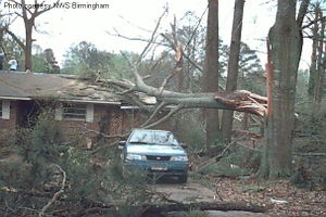
F0 (T0-T1) damage is characterized by superficial damage to structures and vegetation. Well-built structures are typically unscathed, sometimes sustaining broken windows, with minor damage to roofs and chimneys. Billboards and large signs can be knocked down. Trees may have large branches broken off, and can be uprooted if they have shallow roots.
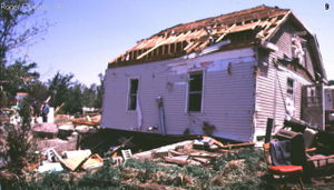
F1 (T2-T3) damage has caused significantly more fatalities than that caused by F0 tornadoes. At this level, damage to mobile homes and other temporary structures becomes significant, and cars and other vehicles can be pushed off the road. Permanent structures can suffer major damage to their roofs.
- Significant tornadoes
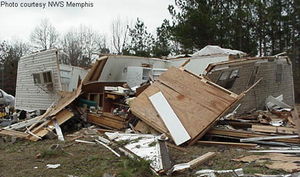
F2 (T4-T5) tornadoes are the lower end of "significant", and yet are stronger than most tropical cyclones (though tropical cyclones affect a much larger area). Well-built structures can suffer serious damage, including roof loss and collapse of outer walls. Mobile homes, however, are almost totally destroyed. Vehicles can be lifted off the ground, and lighter objects can become small missiles, causing damage outside of the tornado's main path. Wooded areas will have a large percentage of their trees snapped or uprooted.
F3 (T6-T7) damage is a serious risk to life and limb. Few parts of affected buildings are left standing; well-built structures lose outer and inner walls. Cars are lifted off the ground, and can be tossed through the air for some distance. Wooded areas will suffer almost total loss of vegetation.
- Violent tornadoes
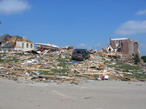
F4 (T8-T9) damage typically results in a total loss of the affected structure. Well-built homes are reduced to a short pile of debris. Even heavy vehicles, including airplanes, trains, and large trucks, can become airborne, with other large projectiles being flung some distance.
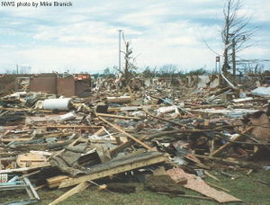
F5 (T10+) damage is almost always total. F5 tornadoes demolish well-built houses and sweep the foundation clean. The official description of this damage states that "incredible phenomena will occur". The damage they cause is an extreme hazard to life and limb—since 1950 in the United States, only 50 tornadoes (0.1% of all reports) have been designated F5, and yet these have been responsible for more than 1000 deaths and 11,000 injuries (21.5% and 13.6%, respectively). In recorded history, F5 tornadoes have performed awesome displays of power, including twisting skyscrapers, levelling entire communities, and stripping asphalt from the ground.
Prediction
The following organizations provide official or de facto official tornado and severe convective storm forecasts and warnings.
Australia
Severe thunderstorm warnings are provided to Australia by their Bureau of Meteorology. The country is in the middle of an upgrade to Doppler radar systems, with their first benchmark of installing six new radars reached in July 2006.
Canada
In Canada, weather forecasts and warnings, including tornadoes, are produced by the Meteorological Service of Canada division of Environment Canada.
Europe
The European Union founded a project in 2002 called the European Severe Storms virtual Laboratory, or ESSL, which is meant to fully document tornado occurrence across the continent. The ESTOFEX (European Storm Forecast Experiment) arm of the project also issues one day forecasts for severe weather likelihood.
Germany, Austria, and Switzerland
An organization known as TorDACH was founded in 1997 to collect information regarding tornadoes, waterspouts, and downbursts from Germany, Austria, and Switzerland. A secondary goal is collect all severe weather information. This project is meant to document fully severe weather activity in these three countries.
Japan
In Japan, predictions and study of tornadoes in Japan are handled by the Japan Meteorological Agency.
United Kingdom
In the United Kingdom, the Tornado and Storm Research Organisation (TORRO) makes experimental predictions.
United States
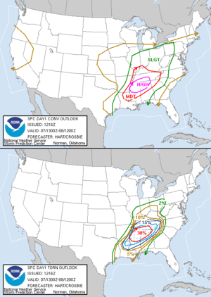
In the United States, generalized severe weather predictions are issued by the Storm Prediction Centre, based in Norman, Oklahoma. For the next one, two, and three days, respectively, they will issue categorical and probabilistic forecasts of severe weather, including tornadoes. There is also a more general forecast issued for the four to eight day period. Just prior to the expected onset of an organized severe weather threat, SPC issues severe thunderstorm and tornado watches, in collaboration with local National Weather Service offices. Warnings are issued by local National Weather Service offices when a severe thunderstorm or tornado is occurring or imminent.
Detection
The National Weather Service trains Skywarn spotters, consisting of local sheriff's deputies, state troopers, firefighters, amateur radio operators, storm chasers, and ordinary citizens, to spot key features of storms which indicate severe hail, strong winds, and tornadoes. When severe weather is anticipated, local weather service offices request that these spotters be on the lookout for severe weather, and report any possible tornadoes immediately, so the office can issue a timely warning.
Climatology
Geography
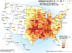
The United States has the most tornadoes of any country, seeing about four times the activity estimated in all of Europe. Many of these form in an area of the central United States known as Tornado Alley. This area extends into Canada, particularly Ontario and the Prairie Provinces, however, activity is less than that of the US. The Netherlands has the highest average number of recorded tornadoes per area of any country (more than 20 annually), followed by the UK (at least 33 per year), but most are small and result in minor damage.
Bangladesh and surrounding areas of eastern India suffer from tornadoes of equal severity to those in the US with more regularity than any other region in the world, however these occur with greater recurrence interval, and tend to be under-reported due to the scarcity of media coverage in a third-world country. The annual human death toll is about 179 deaths per year from tornadoes in Bangladesh, which is much greater than in the US. This is likely due to the density of population, poor quality of construction, lack of tornado safety knowledge, and other factors..
Other areas of the world that have more frequent strong tornadoes include parts of Argentina and southern Brazil as well as South Africa. A fair number of weak and occasionally strong tornadoes occurs annually in Germany, Italy, and China. Australia, France, Spain, Russia, areas of the Middle East, and Japan have a history of multiple damaging tornado events.
Frequency of occurrence
Tornadoes can form almost every month, providing the conditions are favorable. Though they are scarce during the Winter months, they are abundant in Spring. Although Autumn isn't a common season for tornado outbreaks, they are significantly spotted, although in way lower numbers than in Spring. Since Autumn and Spring are transitional periods (warm to cool and vice versa)there are more chances of cooler air meeting with warmer air, resulting in thunderstorms. Summer can provide some storms too, but these are mostly afternoon showers. Significant numbers of tornadoes in the summertime are due to hurricane landfalls in the Gulf Coast states and their remnants traveling northward. Also, sometimes, a cold front may drop from the north, resulting in a possible thunderstorm.
Time of occurrence
Tornado occurrence is highly dependant on the time of day. Austria, Finland, Germany, and the United States' peak hour of occurrence is 5 p.m., with roughly half of all tornado occurrence between 3 p.m. and 7 p.m. local time.
Extremes
Tornadoes are the most violent weather events in the world. As such, they have been recorded to produce some incredible phenomena.
In terms of the most extreme tornado in history, the honour undoubtedly goes to the Tri-State Tornado which roared through parts of Missouri, Illinois, and Indiana on March 18, 1925. This tornado, likely an F5 (though this was before the era where tornadoes were ranked on the Fujita scale), set (and still holds) records for the deadliest single United States tornado (695 dead), longest path length (219 miles, 352 km), longest duration (about 3.5 hours), and fastest forward speed for a significant tornado (73 mph, 117 km/h). It was also the second costliest tornado in history at the time, but has since been surpassed by several others non-normalized, it still ranks third when normalized for wealth and inflation.
The deadliest tornado in world history occurred on April 26, 1989 in Bangladesh, killing approximately 1300 people.
The most extensive tornado outbreak on record, in almost every category, was the Super Outbreak, which affected a large area of the Central United States and extreme southern Ontario in Canada on April 3 and 4, 1974. Not only did this outbreak feature an incredible 148 tornadoes in only 18 hours, but an unprecedented amount of them were violent; six of the tornadoes were of F5 intensity, and 24 were of F4 intensity. More than 300 people, possibly as many as 330, were killed by tornadoes during this outbreak.
While it is nearly impossible to directly measure the most violent tornado wind speeds (conventional anemometers would be destroyed by the intense winds), some tornadoes have been scanned by mobile doppler radar units, which can provide a good estimate of the tornado's winds. The highest wind speed ever measured in a tornado, which is also the highest wind speed ever recorded on the planet, is 301 mph (484 km/h) in the F5 Moore, Oklahoma tornado. Though there was an uncertainty in the measurement of about 20 mph, and the reading was taken about 100 feet (30 m) above the ground, this is a testament to the power of the strongest tornadoes.
Storms which produce tornadoes can feature intense updrafts (sometimes exceeding 150 mph, 240 km/h). As such, debris from a tornado can be lofted into the parent storm, and be carried for very long distances. A tornado which affected Great Bend, Kansas in November, 1915 was an extreme case, where a "rain of debris" occurred 80 miles (130 km) from the town, a sack of flour was found 110 miles (177 km), and a cancelled check from the Great Bend bank was found in a field outside of Palmyra, Nebraska, 305 miles (491 km) to the northeast.
Tornado safety
Precautions
Though tornadoes can strike in an instant, there are precautions and preventative measures that you can take in order to increase the chances of surviving a tornado.
In tornado-prone areas, many buildings have storm cellars on the property. These underground refuges have saved thousands of lives.
Prepare a plan of action before a tornado threatens. Tornado drills test the effectiveness of the plan and make others aware of it.
Some countries have meteorological agencies which distribute tornado forecasts and increase levels of alert of a possible tornado (such as watches and warnings in the United States and Canada). Weather radios (where available) provide alarm when increased tornadic threat is detected for your local area. Being aware of the different terminology used by your weather organization and monitoring data sources (which can also include the Internet, television, and radio) for information can increase the warning you have for a tornado.
If a tornado approaches while you are...
- Outside
Seek shelter immediately inside a sturdy building. If such a building is out of your reach, a ditch or culvert can be used as a last resort.
- Driving... and the tornado is quite distant
Try to remain calm and drive in a direction that takes you away from where the tornado is moving. While the tornado is a threat, so are traffic accidents induced by panic.
- Driving... and the tornado is near or other circumstances prevent escape
Look for safe shelter. If you find it, park your car away from travel lanes and hastily move into the shelter. Highway overpasses are not safe shelter. Vehicles are extremely dangerous locations to be caught in during a tornado, but making alert decisions can save your life.
- Inside a house or other building
If inside a weak structure, such as a shed or mobile home, try to relocate to a stronger shelter if possible. If inside a stronger structure, seek shelter in the basement or tornado shelter. If the structure does not have a such options, or if the tornado is so close that it will not allow you to reach it, go to the innermost part of the building (commonly under the stairs, a bathroom, or an interior hallway in a house, or a bathroom, stairwell, or interior office in a larger building), preferably on the lowest level. Whatever location you go to, attempt to seek protection under a sturdy object such as a workbench or heavy table, and cover yourself (with objects like blankets, pillows, cushions, and even clothing) for additional protection.
- In all cases:
Get as low as possible, and attempt to protect your head and vital organs as best you can. Remain in your shelter until you are certain the tornado has moved past, and be careful of debris when exiting your shelter.
Myths and misconceptions
One of the most persistant myths associated with tornadoes is that opening windows will lessen the damage caused by the tornado. While it is true that there is a large drop in atmospheric pressure inside a strong tornado, it is unlikely that the pressure drop would be enough to cause the house to explode. In fact, some research indicates that opening windows may indeed increase the severity of the tornado's damage. Regardless of the validity of the explosion claim, however, time would be better spent seeking shelter before a tornado than opening windows.
Another commonly held belief is that highway overpasses provide adequate shelter from tornadoes. On the contrary, a highway overpass is a very dangerous place to be during a tornado. During the Oklahoma Tornado Outbreak of May 3, 1999, three highway overpasses were directly struck by tornadoes, and at all three there was a fatality, along with many life-threatening injuries. During the same tornado outbreak, more than 2000 homes were completely destroyed, with another 7000 damaged, and yet only a few dozen people died in their homes. Similarly, an old belief was that the southwest corner of a basement provides the most protection during a tornado. In actuality, the northeast corner of a building is the safest, and taking shelter under a sturdy table, in a basement, or under a staircase increases chances of survival even more.
Finally, there are areas which people believe to be protected from tornadoes, whether by a major river, a hill or mountain, or even protected by " spirits". All of these are untrue assumptions, as tornadoes have been known to cross major rivers, climb mountains, and affect valleys. As a general rule, no area is "safe" from tornadoes, though some areas are more susceptible than others (see the Geography section).
Continuing research
Though scientists have learned much from years of research, there are still many things about tornadoes which remain a mystery. In fact, scientists still don't know the exact method by which most tornadoes form. Research programs, including VORTEX, deployment of TOTO (the TOtable Tornado Observatory), and dozens of other programs, hope to solve many questions that still plague meteorologists.
Social implications of tornadoes
Tornado damage to man-made structures is a result of the high wind velocity and windblown debris. Tornadic winds have been measured in excess of 300 mph (480 km/h). Tornado season in North America is generally March through November, although tornadoes can occur at any time of year. They tend to occur in the afternoons and evenings; over 80% of all tornadoes strike between noon and midnight.
Some individuals and hobbyists, known as storm chasers, enjoy pursuing thunderstorms and tornadoes to explore their many visual and scientific aspects. Attempts have been made by some storm chasers from educational and scientific institutions to drop probes in the path of oncoming tornadoes in an effort to analyze the interior of the storms, but only about five drops have been successful since around 1990.
Due to the relative rarity and large scale of destructive power that tornadoes possess, their occurrence or the possibility that they may occur can often create what could be considered sensationalism in their reporting. This results in so-called weather wars, in which competing local media outlets, particularly TV news stations, engage in continually escalating technological one-upsmanship and drama in order to increase their market share. This is especially evident in tornado-prone markets, such as those in the Great Plains.
According to Environment Canada, the chances of being killed by a tornado are 12 million to 1 (12,000,000:1). One may revise this yearly and/or regionally, but the probability may be factually stated to be low. Tornadoes do cause millions of dollars in damage, both economic and physical, displacement, and many injuries every year.[ citations needed]
Cultural significance
Tornadoes as a metaphor
The tornado has been used by cartoonists for over 100 years as a metaphor for political upheaval. For example, according to political interpretations of The Wonderful Wizard of Oz, the tornado takes Dorothy to a utopia, the Land of Oz, and kills the Wicked Witch of the East, who had oppressed a little people, the Munchkins.. The storm cellar has also been used as a metaphor for seeking safety, as shown in the cartoon from 1894 at right.
A 1960s advertising campaign for the household cleaner, Ajax, claimed the product "Cleans like a white tornado".
Tornadoes in dreams are sometimes said to be associated with fear, chaos, and upheaval. It is alleged that the location where one is during a tornado dream, e.g. at home, can help to determine the meaning.[ citations needed]
Motion pictures with a tornado theme
- The Wizard of Oz, 1939.
- Mr. and Mrs. Bridge, 1990.
- Night of the Twisters (TV), 1996.
- Tornado! (TV), 1996.
- Twister, 1996.
- Atomic Twister (TV), 2001.
- The Day After Tomorrow, 2004.
- Perfect Disaster: Super Tornado (Discovery Channel), premiered on March 19, 2006.
- Category 7: The End of the World, 2005.
