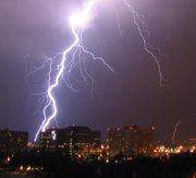
Thunderstorm
2007 Schools Wikipedia Selection. Related subjects: Climate and the Weather; Storms
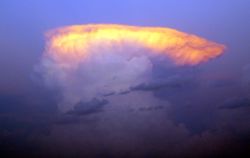
A thunderstorm, also called an electrical storm, is a form of weather characterized by the presence of lightning and its attendant thunder produced from a cumulonimbus cloud. Thunderstorms are usually accompanied by heavy rainfall and they can also be accompanied by strong winds, hail and tornadoes. In the winter months, snowfall can occasionally take place in a thunderstorm. Such is often termed thundersnow.
Thunderstorms form when significant condensation—resulting in the production of a wide range of water droplets and ice crystals—occurs in an atmosphere that is unstable and supports deep, rapid upward motion. This often occurs in the presence of three conditions: sufficient moisture accumulated in the lower atmosphere, reflected by high temperatures; a significant fall in air temperature with increasing height, known as a steep adiabatic lapse rate; and a force such as mechanical convergence along a cold front to focus the lift. The process to initiate vertical lifting can be caused by (1) unequal warming of the surface of the Earth, (2) orographic lifting due to topographic obstruction of air flow, and (3) dynamic lifting because of the presence of a frontal zone.
Thunderstorms have had a lasting and powerful influence on early civilizations. Romans thought them to be battles waged by Jupiter, who hurled lightning bolts forged by Vulcan. Thunderstorms were associated with the Thunderbirds, held by Native Americans to be a servant of the Great Spirit.
According to Encyclopedia Britannica, if the quantity of water that is condensed in and subsequently precipitated from a cloud is known, then the total energy of a thunderstorm can be calculated. In an average thunderstorm, the energy released amounts to about 10,000,000 kilowatt-hours ( 3.6 x 10¹³ joule), which is equivalent to a 20-kiloton nuclear warhead. A large, severe thunderstorm might be 10 to 100 times more energetic.
Classification
There are four main types of thunderstorms: single cell, multicell, squall line (also called multicell line) and supercell. Which type forms depends on the instability and relative wind conditions at different layers of the atmosphere (" wind shear"):
- Single cell storms form when the atmosphere is not strong enought, but there is little or no wind shear, meaning precipitation falls back down through the updraft that led to it, cooling it and eventually killing it. These storms are short lived, and last for less than an hour after becoming strong enough to produce lightning. Days with suitable weather conditions often see the repeated forming and dissipation of such storms, leading them to be known as "pulse" storms.
- Multicell storms are groups of cells in different stages of development which have merged into a larger system. The cloud becomes divided into updraft and downdraft regions separated by a gust front. The gust front may extend for several miles ahead of the storm, bringing with it increases in wind speed and atmospheric pressure, decreases in temperature, and shifts in wind direction. The storm itself will have different portions sequentially going through the various thunderstorm stages. In many cases the immature cells develop along a flanking line, resulting in what is known as a line multicell.
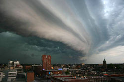
- Squall line or multicell line storms are formed as an organized line or lines of multicell storms frequently with a gust front. This kind of storm is also known as "Wind of the Stony Lake" (Traditional Chinese:石湖風, Simplified Chinese: 石湖风) in southern China. They often arise from convective updrafts in or near mountain ranges and linear weather boundaries, usually strong cold fronts or troughs of low pressure. Occasionally, squall lines are also formed near the outer rain band of the tropical cyclones. The squall line is propelled by its own outflow, which reinforces continuous development of updrafts along the leading edge. Squall lines tend to be hundreds of miles long, sometimes stretching across the Midwestern United States, covering five states at a time. These lines can move swiftly and in some parts of the line, bow echoes can form, bringing with it high winds, dangerous lightning, and possibly tornadoes. Heavy rain, hail and very strong winds over a large area such as derechos can occur in a squall line.
- Supercell storms are large, severe quasi-steady-state storms which feature wind speed and direction that vary with height ("wind shear"), separate downdrafts and updrafts (i.e., precipitation is not falling through the updraft) and a strong, rotating updraft (a " mesocyclone"). These storms normally have such powerful updrafts that the top of the cloud (or anvil) can reach miles into the air and can be 15 miles wide. These storms produce destructive tornadoes, sometimes F3 or higher, extremely large hailstones (4 inch—10 cm—diameter), straight-line winds in excess of 80 mph (130 km/h), and flash floods. In fact, most tornadoes occur from this kind of thunderstorm.
Multicell or squall line systems may form within a meteorologically important feature known as mesoscale convective system (MCS) stretching for hundreds of kilometres. The mesoscale convective complex is a closely related phenomenon. They are large enough to have a pronounced effect on the upper-level and surface weather pattern, and may influence forecasts over a large area. MCS systems are common in the Midwest region of the United States and the Canadian Prairies during the summer months and produce much of the region's important agricultural rainfall. Prior to the discovery of the MCS phenomenon, the individual thunderstorms were thought of as independent entities, each being effectively impossible to predict. The MCS is amenable to forecasting, and a meteorlogist can now predict with high accuracy the percentage of the MCS that will be affected by thunderstorms. However, the meteorlologist still cannot predict exactly where each thunderstorm will occur within the MCS.
Severe thunderstorm
A severe thunderstorm is a thunderstorm with winds 92.5 kilometers/hour (57.5 mph) or greater, 1.9 centimeter (¾ in) or larger hail, funnel clouds or tornadoes. These storms may contain frequent cloud-to-ground lightning and heavy downpours which can lead to localized flooding. This is a general definition which varies by country and is somewhat contentious. An otherwise weak thunderstorm which produces a wind gust of the required strength would be defined as 'severe' whereas a very violent thunderstorm with continuous lightning and very heavy rain (but without the required wind gusts, hail or tornado/funnel cloud) would not. Many of the violent local thunderstorms which affect Florida so frequently during the summer months would not be defined as severe.
Severe thunderstorms may occur as supercell thunderstorms, although multicell and squall lines are the most common forms.
Where thunderstorms occur
Thunderstorms occur throughout the world, even in the polar regions, with the greatest frequency in tropical rainforest areas, where they may occur nearly daily. Kampala and Tororo in Uganda have each been mentioned as the most thunderous places on Earth, an accolade which has also been bestowed upon Bogor on Java, Indonesia. In temperate regions, they are most frequent in spring and summer, although they can occur in cold fronts at any time of year. Thunderstorms are rare in polar regions due to the cold climate and stable air masses that are generally in place, but they do occur from time to time, mainly in the summer months.
In more contemporary times, thunderstorms now have taken on the role of a curiosity. Every spring, storm chasers head to the Great Plains of the United States and the Canadian Prairies in summer to explore the visual and scientific aspects of storms and tornadoes.
Life cycle
 |
 |
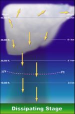 |
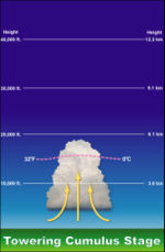
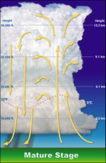
| An airflow diagram of the towering cumulus stage | An airflow diagram of the mature stage | An airflow diagram of the dissipation stage |
A given cell of a thunderstorm goes through three stages: the cumulus stage, the mature stage, and the dissipation stage.
- In the cumulus stage of a thunderstorm cell, masses of moisture are pushed upwards. The trigger for this can be solar insolation heating the ground producing thermals, areas where two winds converge forcing air upwards, or where winds blow over areas of high ground. The moisture rapidly cools into liquid drops of water, which appears as cumulus clouds. As the water vapour condenses into liquid, latent heat is released which warms the air, causing it to become less dense than the surrounding dry air, and so the air will tend to rise in an updraft due to the process of convection (hence the term convective precipitation). This creates a low-pressure zone beneath the forming thunderstorm. In a typical thunderstorm, some 5×10⁸ kg of water vapour are lifted and the amount of energy released when this condenses is about equal to the energy used by a city (US-2002) of 100,000 during a month.
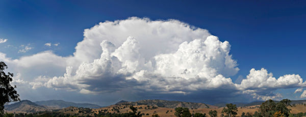
- In the mature stage, the warmed air continues to rise until it reaches existing air which is itself warmer, and the air can rise no further. Often this 'cap' is the tropopause. The air is instead forced to spread out, giving the storm a characteristic anvil shape. The resulting cloud is called cumulonimbus incus. The water droplets coalesce into heavy droplets and freeze to become ice particles. As these fall they melt, to become rain. If the updraft is strong enough, the droplets are held aloft long enough to be so large that they do not melt completely as they fall and fall as hail. While updrafts are still present, the falling rain creates downdrafts as well. The presence of both updrafts and downdrafts during this stage can cause considerable internal turbulence in the storm system, which sometimes manifests as strong winds, severe lightning, and even tornadoes. If there is little wind shear, the storm will rapidly 'rain itself out', but if there is sufficient change in wind speed and/or direction the downdraft will be separated from the updraft, and the storm may become a supercell.
- Finally, in the dissipation stage, updraft conditions no longer exist, and the storm is characterized largely by weak downdrafts. Because most of the moisture has precipitated out, there is not sufficient moisture in the lower air to sustain the cycle and the thunderstorm dissipates.
Lightning
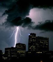
Lightning is an electrical discharge that occurs in a thunderstorm. It can be seen in the form of a bright streak (or bolt) from the sky. Lightning occurs when a charge is built up within a cloud. When a large enough charge is built up, a large discharge will occur and can be seen as lightning. The temperature of a lightning bolt can be hotter than the surface of the sun. Although the lightning is extremely hot, the short duration makes it not necessarily fatal. Contrary to the popular idea that lightning doesn’t strike twice in the same spot, some people have been struck by lightning over three times and skyscrapers like the Empire State Building have been struck numerous times in the same storm.
There are several kinds of lightning.
- In-cloud lightning is the most common. It is lightning within a cloud. Sometimes called cloud to cloud or sheet lightning.
- Cloud to ground lightning is when a bolt of lightning from a cloud strikes the ground. This form poses the greatest threat to life and property.
- Ground to cloud lightning is when a lightning bolt is induced from the ground to the cloud.
- Cloud to cloud lightning is rarely seen and is when a bolt of lightning arches from one cloud to another.
- Ball lightning is extremely rare and has no known scientific explanation. It is seen in the form of a 20 to 200 centimeter ball.
- Cloud to air lightning is when lightning from a cloud hits air of a different charge.
