Enceladus (moon)
2007 Schools Wikipedia Selection. Related subjects: Space (Astronomy)
 larger version |
|||||||
| Discovery | |||||||
|---|---|---|---|---|---|---|---|
| Discovered by | William Herschel | ||||||
| Discovered on | August 28, 1789 | ||||||
| Orbital characteristics | |||||||
| Semimajor axis | 237,948 km | ||||||
| Eccentricity | 0.0047 | ||||||
| Orbital period | 1.370218 d | ||||||
| Inclination | 0.019° (to Saturn's equator) | ||||||
| Satellite of | Saturn | ||||||
| Physical characteristics | |||||||
| Mean diameter | 504.2 km (513.2×502.8×496.6 km) (0.0395 Earths) |
||||||
| Mass | 1.08×10²⁰ kg (1.8×10⁻⁵ Earths) |
||||||
| Mean density | 1.61 g/cm3 | ||||||
| Surface gravity | 0.113 m/s2 (0.0115 g) | ||||||
| Escape velocity | 0.241 km/s (866 km/h) | ||||||
| Rotation period | synchronous | ||||||
| Axial tilt | zero | ||||||
| Albedo/Geometric albedo | 0.99/1.41 | ||||||
| Surface temperature |
|
||||||
| Atmospheric characteristics | |||||||
| Pressure | trace, significant spatial variability , |
||||||
| Water vapour | 91% | ||||||
| Carbon dioxide | 3.2% | ||||||
| Nitrogen | 4% , | ||||||
| Methane | 1.7% | ||||||
Enceladus (en-sel'-ə-dəs, IPA: /ɛnˈsɛlədəs/), discovered in 1789 by William Herschel, is the sixth-largest moon of Saturn. Until the two Voyager spacecraft passed near it in the early 1980s, very little was known about this small moon besides the identification of water ice on its surface. The Voyagers showed that Enceladus is only 500 kilometers in diameter and reflects almost 100% of the sunlight that strikes it. Voyager 1 found that Enceladus orbited in the densest part of Saturn's diffuse E ring, indicating a possible association between the two, while Voyager 2 revealed that despite the moon's small size, it had a wide range of terrains ranging from old, heavily cratered surfaces to young, tectonically-deformed terrain, with some regions with surface ages as young as 100 million years old.
The Cassini spacecraft of the mid- to late 2000s acquired additional data on Enceladus, answering a number of the mysteries opened by the Voyager spacecraft and starting a few new ones. Cassini performed several close flybys of Enceladus in 2005, revealing the moon's surface and environment in greater detail. In particular, the probe discovered a water-rich plume venting from the moon's south polar region. This discovery, along with the presence of escaping internal heat and very few (if any) impact craters in the south polar region, shows that Enceladus is geologically active today. Moons in the extensive satellite systems of gas giants often become trapped in orbital resonances that lead to forced libration or orbital eccentricity; proximity to the planet can then lead to tidal heating of the satellite's interior, offering a possible explanation for the activity.
Enceladus is one of only three outer solar system bodies (along with Jupiter's moon Io and Neptune's moon Triton) where active eruptions have been observed. Analysis of the outgassing suggests that it originates from a body of sub-surface liquid water, which along with the unique chemistry found in the plume, has fueled speculations that Enceladus may be important in the study of astrobiology. The discovery of the plume has added further weight to the argument that material released from Enceladus is the source of the E-ring.
Name
Enceladus is named after the Titan Enceladus of Greek mythology. It is also designated Saturn II or S II Enceladus. The name Enceladus – like the names of each of the first seven satellites of Saturn to be discovered – was suggested by William Herschel's son John Herschel in his 1847 publication Results of Astronomical Observations made at the Cape of Good Hope. He specifically chose these names because Saturn, known in Greek mythology as Chronos, was the leader of the Titans.
Features on Enceladus are named after characters and places from the Arabian Nights by the International Astronomical Union (IAU). Impact craters are named after characters from Arabian Nights, while other feature types, such as Fossae (long, narrow depressions), Dorsa (ridges), Planitia ( plains), and Sulci (long parallel grooves), are named after places. 57 features have been officially named by the IAU; 22 features were named in 1982 based on the results of the Voyager flybys, and 35 features were approved in November 2006 based on the results of Cassini's three flybys in 2005. Examples of approved names include Samarkand Sulci, Aladdin crater, Daryabar Fossa, and Sarandib Planitia.
Exploration
Enceladus was discovered by Fredrick William Herschel on August 28, 1789, during the first use of his new 1.2-meter telescope, then the largest in the world., Herschel first observed Enceladus in 1787, but in his smaller, 16.5- cm telescope, the moon was not recognized. Due to Enceladus' faint apparent magnitude (+11.8m) and its proximity to much brighter Saturn and its rings, Enceladus is difficult to observe from Earth, requiring a telescope with a mirror of at least 30 cm in diameter, depending on atmospherical conditions and light pollution. Like many Saturnian satellites discovered prior to the Space Age, Enceladus was first observed during a ring crossing, when Earth is within the ring plane during Saturnian equinox. During these periods, Enceladus is easier to observe due to the reduction in glare from the rings.
Prior to the Voyager program, the view of Enceladus improved little from the dot first observed by Herschel. Only its orbital characteristics, along with an estimation of its mass, density, and albedo, were known.
| Planned Cassini encounters with Enceladus | |
|---|---|
| Date | Distance (km) |
| February 17, 2005 | 1,264 |
| March 9, 2005 | 500 |
| March 29, 2005 | 64,000 |
| May 21, 2005 | 93,000 |
| July 14, 2005 | 175 |
| October 12, 2005 | 49,000 |
| December 24, 2005 | 94,000 |
| January 17, 2006 | 146,000 |
| September 9, 2006 | 40,000 |
| November 9, 2006 | 95,000 |
| June 28, 2007 | 90,000 |
| September 30, 2007 | 98,000 |
| March 12, 2008 | 23 |
| June 30, 2008 | 101,000 |
The two Voyager spacecraft obtained the first spacecraft images of Enceladus. Voyager 1 was the first to fly past Enceladus, at a distance of 202,000 km on November 12, 1980. Images acquired from this distance had very poor spatial resolution, but revealed a highly reflective surface devoid of impact craters, indicating a youthful surface. Voyager 1 also confirmed that Enceladus was embedded in the densest part of Saturn's diffuse E-ring. Combined with the apparent youthful appearance of the surface, Voyager scientists suggested that the E-ring consisted of particles vented from Enceladus' surface.
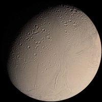
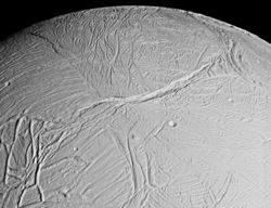
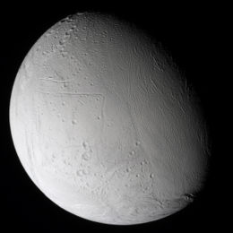
Voyager 2 passed closer to Enceladus (87,010 km) on August 26, 1981, allowing much higher resolution images of this satellite. These images revealed the youthful nature of much of its surface, as seen in Figure 1. They also revealed a surface with different regions with vastly different surface ages, with a heavily cratered mid- to high-northern latitude region, and a lightly cratered region closer to the equator. This geologic diversity contrasts with the ancient, heavily cratered surface of Mimas, another moon of Saturn slightly smaller than Enceladus. The geologically youthful terrains came as a great surprise to the scientific community, because no theory was then able to predict that such a small (and cold, compared to Jupiter's highly active moon Io) celestial body could bear signs of such activity. However, Voyager 2 failed to determine whether Enceladus was currently active or whether it was the source of the E-ring.
The answer to these and other mysteries would have to wait until the arrival of the Cassini spacecraft on July 1, 2004, when it went into orbit around Saturn. Given the results from the Voyager 2 images, Enceladus was considered a priority target by the Cassini mission planners, and several targeted flybys within 1,500 km of the surface were planned as well as numerous, "non-targeted" opportunities within 100,000 km of Enceladus. These encounters are listed at right. So far, three close flybys of Enceladus have been performed, yielding significant information concerning Enceladus' surface, as well as the discovery of water vapor venting from the geologically active South Polar Region. These discoveries have prompted the adjustment of Cassini's flight plan to allow closer flybys of Enceladus, including an encounter in March 2008 which will take the probe to within 23 km of the moon's surface.
Characteristics
Orbit
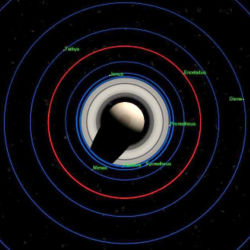
Enceladus is one of the major inner satellites of Saturn. It is the fourteenth satellite when ordered by distance from Saturn, and orbits within the densest part of the E Ring, the outermost of Saturn's rings, an extremely wide but very diffuse disk of microscopic icy or dusty material, beginning at the orbit of Mimas and ending somewhere around the orbit of Rhea.
Enceladus orbits Saturn at a distance of 238,000 km from the planet's centre and 180,000 km from its cloudtops, between the orbits of Mimas and Tethys, requiring 32.9 hours to revolve once (fast enough for its motion to be observed over a single night of observation). Enceladus is currently in a 2:1 mean motion orbital resonance with Dione, completing two orbits of Saturn for every one orbit completed by Dione. This resonance helps maintain Enceladus' orbital eccentricity (0.0047) and provides a heating source for Enceladus' geologic activity.
Like most of the larger satellites of Saturn, Enceladus rotates synchronously with its orbital period, keeping one face pointed toward Saturn. Unlike the Earth's moon, Enceladus does not appear to librate about its spin axis (more than 1.5°). However, analysis of the shape of Enceladus suggests that at some point it was in a 1:4 forced secondary spin-orbit libration. This libration, like the resonance with Dione, could have provided Enceladus with an additional heat source.
Interaction with E Ring
The E Ring is the widest and outermost ring of Saturn. It is an extremely wide but very diffuse disk of microscopic icy or dusty material, beginning at the orbit of Mimas and ending somewhere around the orbit of Rhea, though some observations suggest that it extends beyond the orbit of Titan, making it 1,000,000 km wide. However, numerous mathematical models show that such a ring is unstable, with a lifespan between 10,000 and 1,000,000 years. Therefore, particles composing it must be constantly replenished. Enceladus is orbiting inside this ring, in a place where it is narrowest but present in its highest density. Therefore, several theories suspected Enceladus to be the main source of particles for the E Ring. This hypothesis was proven by Cassini's flyby.
There are actually two distinct mechanisms feeding the ring with particles. The first, and probably the most important, source of particles comes from the cryovolcanic plume in the South polar region. While a majority of particles fall back to the surface, some of them escape Enceladus' gravity and enter orbit around Saturn, since Enceladus' escape velocity is only 866 km/h. The second mechanism comes from meteoric bombardment of Enceladus, raising dust particles from the surface. This mechanism is not unique to Enceladus, but is valid for all Saturn's moons orbiting inside the E Ring.
Size and shape
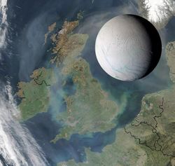
Enceladus is a relatively small satellite, with a mean diameter of 505 km, making it only one-seventh as large as Earth's own Moon. Its dimensions would allow the satellite to be placed inside a state such as Arizona or Colorado, or the British Isles (see picture), although as a spherical object its surface area is much greater, just over 800,000 square km, almost the same as Mozambique, or 15% larger than Texas.
Its mass and diameter make Enceladus the sixth most massive and largest satellite of Saturn, after Titan (5550 km), Rhea (1530 km), Iapetus (1440 km), Dione (1120 km) and Tethys (1050 km). It is also one of the smallest of Saturn's spherical satellites, since all smaller satellites except Mimas (390 km) have an irregular shape.
Enceladus' exact dimensions, calculated from pictures taken by Cassini's ISS instrument, are of 513(a)×503(b)×497(c) km, with (a) corresponding to the diameter between the points on the surface facing toward and away from Saturn, (b) to the diameter between the points that face toward and away from the direction of Enceladus' orbital motion and (c) to the distance between the poles. Therefore, Enceladus has a shape of a flattened ellipsoid.
Surface
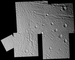
Voyager 2, in August of 1981, was the first spacecraft to observe the surface in detail. Examination of the resulting highest resolution mosaic reveals at least five different types of terrain, including several regions of cratered terrain, regions of smooth (young) terrain, and lanes of ridged terrain often bordering the smooth areas. In addition, extensive linear cracks and scarps were observed. Given the relative lack of craters on the smooth plains, these regions are probably less than a few hundred million years old. Accordingly, Enceladus must have been recently active with " water volcanism" or other processes that renew the surface. The fresh, clean ice that dominates its surface gives Enceladus the most reflective surface of any body in the solar system with a visual geometric albedo of 1.41. Because it reflects so much sunlight, the mean surface temperature at noon only reaches -198 °C (somewhat colder than other Saturnian satellites).
Observations during three flybys by Cassini on February 17, March 9, and July 14 of 2005 revealed Enceladus' surface features in much greater detail than the Voyager 2 observations. For example, the smooth plains observed by Voyager 2 resolved into relatively crater-free regions filled with numerous small ridges and scarps. In addition, numerous fractures were found within the older, cratered terrain, suggesting that the surface has been subjected to extensive deformation after the craters were formed. Finally, several additional regions of young terrain were discovered in areas not well-imaged by either Voyager spacecraft, such as the bizarre terrain near the south pole.
Impact craters
Impact cratering is a common occurrence on many solar system bodies. Much of Enceladus's surface is covered with craters at various densities and levels of degradation. From Voyager 2 observations, three different units of cratered topography were identified on the basis of their crater densities, from ct1 and ct2, both containing numerous 10-20 km-wide craters though differing in the degree of deformation, to cp consisting of lightly cratered plains. This subdivision of cratered terrains on the basis of crater density (and thus surface age), suggests that Enceladus has been resurfaced in multiple stages.
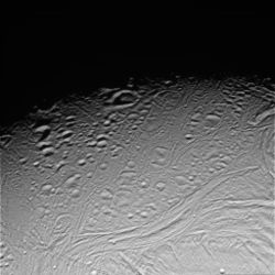
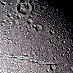
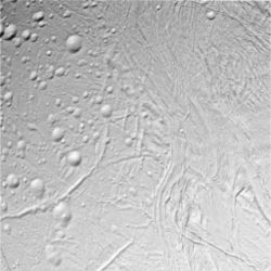
Recent Cassini observations have provided a much closer look at the ct2 and cp cratered units. These high-resolution observations, like Figure 5, reveal that many of Enceladus' craters are heavily deformed through viscous relaxation and fracturing. Viscous relaxation causes craters and other topographic features formed in water ice to deform over geologic time scales due to the effects of gravity, reducing the amount of topography over time. The rate at which this occurs is dependent on the temperature of the ice: warmer ice is easier to deform than colder, stiffer ice. Viscously relaxed craters tend to have domed floors, or are recognized as craters only by a raised, circular rim (seen at centre just below the terminator in Figure 5). Dunyazad, the large crater seen in Figure 7 just left of top center, is a prime example of a viscously relaxed crater on Enceladus, with a prominent domed floor. In addition, many craters on Enceladus have been heavily modified by tectonic fractures. The 10-km-wide crater right of bottom centre in Figure 7 is a prime example: thin fractures, several hundred metres to a kilometre wide, have heavily altered the crater's rim and floor. Nearly all craters on Enceladus thus far imaged by Cassini in the Ct2 unit show signs of tectonic deformation. These two deformation styles—viscous relaxation and fracturing—demonstrate that, while cratered terrains are the oldest regions on Enceladus due to their high crater retention, nearly all craters on Enceladus are in some stage of degradation.
Tectonics
Voyager 2 found several types of tectonic features on Enceladus, including troughs, scarps, and belts of grooves and ridges. Recent results from Cassini suggest that tectonism is the dominant deformation style on Enceladus. One of the more dramatic types of tectonic features found on Enceladus are rifts. These canyons can be up to 200 km long, 5-10 km wide, and one km deep. Figure 6 shows a typical large fracture on Enceladus cutting across older, tectonically deformed terrain. Another example can be seen running along the bottom of the frame in Figure 7. Such features appear relatively young, as they cut across other tectonic features and have sharp topographic relief with prominent outcrops along the cliff faces.
Another example of tectonism on Enceladus is grooved terrain, consisting of lanes of curvilinear grooves and ridges. These bands, first discovered by Voyager 2, often separate smooth plains from cratered regions. An example of this terrain type can be seen in Figures 5 and 9 (in this case, a feature known as Samarkand Sulci). Grooved terrain such as Samarkand Sulci are reminiscent of grooved terrain on Ganymede. However, unlike those seen on Ganymede, grooved topography on Enceladus is generally much more complex. Rather than parallel sets of grooves, these lanes can often appear as bands of crudely aligned, chevron-shaped features. In other areas, these bands appear to bow upwards with fractures and ridges running the length of the feature. Cassini observations of Samarkand Sulci have revealed intriguing dark spots (125 and 750 meters wide), which appear to run parallel to narrow fractures. Currently, these spots are interpreted as collapse pits within these ridged plain belts.
In addition to deep fractures and grooved lanes, Enceladus has several other types of tectonic terrain. Figure 8 shows sets of narrow fractures (still several hundred meters wide) that were first discovered by the Cassini spacecraft. Many of these fractures are found in bands cutting across cratered terrain. These fractures appear to propagate down only a few hundred meters into the crust. Many appear to have been influenced during their formation by the weakened regolith produced by impact craters, often changing the strike of the propagating fracture., Another example of tectonic features on Enceladus are the linear grooves first found by Voyager 2 and seen at a much higher resolution by Cassini. Examples of linear grooves can be found in the lower left of the figure at top and Figure 9 (lower left), running from north to south from top centre before turning to the southwest. These linear grooves can be seen cutting across other terrain types, like the groove and ridge belts. Like the deep rifts, they appear to be among the youngest features on Enceladus. However, some linear grooves appear to be softened like the craters nearby, suggesting an older age. Ridges have also been observed on Enceladus, though not nearly to the extent as those seen on Europa. Several examples can be seen in the lower left corner of Figure 6. These ridges are relatively limited in extent and are up to one kilometer tall. One-kilometer high domes have also been observed. Given the level of tectonic resurfacing found on Enceladus, it is clear that tectonism has been an important driver of geology on this small moon for much of its history.
Smooth plains
Two units of smooth plains were also observed by Voyager 2. These plains generally have low relief and have far fewer craters than in the cratered terrains and plains, indicating a relatively young surface age. In one of the smooth plain regions, Sarandib Planitia, no impact craters were visible down to the limit of resolution. Another region of smooth plains to the southwest of Sarandib, is criss-crossed by several troughs and scarps. Cassini has since viewed these smooth plains regions, like Sarandib Planitia and Diyar Planitia at much higher resolution. Cassini images show smooth plain regions to be filled with low-relief ridges and fractures. These features are currently interpreted as being caused by shear deformation. The high resolution images of Sarandib Planitia have revealed a number of small impact craters, which allow for an estimate of the surface age, either 170 million years or 3.7 billion years, depending on assumed impactor population.,
The expanded surface coverage provided by Cassini has allowed for the identification of additional regions of smooth plains, particularly on Enceladus' leading hemisphere (the side of Enceladus that faces the direction of motion as the moon orbits Saturn). Rather than being covered in low relief ridges, this region is covered in numerous criss-crossing sets of troughs and ridges, similar to the deformation seen in the south polar region. This area is on the opposite side of the satellite from Sarandib and Diyar Planitiae, suggesting that the placement of these regions is influenced by Saturn's tides on Enceladus.
South polar region
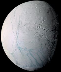
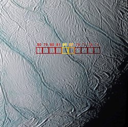
Images taken by Cassini during the flyby on July 14, 2005 revealed a distinctive, tectonically-deformed region surrounding Enceladus' south pole. This area, reaching as far north as 60° south latitude, is covered in tectonic fractures and ridges. The area has few sizable impact craters, suggesting that it is the youngest surface on Enceladus and on any of the mid-sized icy satellites; modeling of the cratering rate suggests that the region is less than 10-100 million years old. Near the centre of this terrain are four fractures bounded on either side by ridges, unofficially called " Tiger stripes". These fractures appear to be the youngest features in this region and are surrounded by mint-green-colored (in false colour, UV-Green-near IR images), coarse-grained water ice, seen elsewhere on the surface within outcrops and fracture walls. Here the "blue" ice is on a flat surface, indicating that the region is young enough not to have been coated by fine-grained water ice from E ring. Results from the Visual and Infrared Spectrometer (VIMS) instrument suggest that the green-colored material surrounding the tiger stripes is chemically distinct from the rest of the surface of Enceladus. VIMS detected crystalline water ice in the stripes, suggesting that they are quite young (likely less than 1,000 years old) or the surface ice has been thermally altered in the recent past. VIMS also detected simple organic compounds in the tiger stripes, chemistry not found anywhere else on the satellite thus far.
One of these areas of "blue" ice in the south polar region was observed at very high resolution during the July 14 flyby, revealing an area of extreme tectonic deformation and blocky terrain, with some areas covered in boulders 10-100 meters across.
The boundary of the South Polar Region is marked by a pattern of parallel, Y- and V-shaped ridges and valleys. The shape, orientation, and location of these features indicate that they are caused by changes in the overall shape of Enceladus. Currently, there are two theories for what could cause such a shift in shape. First, the orbit of Enceladus may have migrated inward, leading to an increase in Enceladus' rotation rate. Such a shift would have lead to a flattening of Enceladus' rotation axis. Another theory suggests that a rising mass of warm, low density material in Enceladus' interior led to a shift in the position of the current south polar terrain from Enceladus' southern mid-latitudes to its south pole. Consequently, the ellipsoid shape of Enceladus would have adjusted to match the new orientation. One consequence of the axial flattening theory is that both polar region should have the similar tectonic deformation histories. However, the north polar region is densely cratered, and has a much older surface age than the south pole. Thickness variations in Enceladus' lithosphere is one explanation for this discrepancy. Variations in lithospheric thickness are supported by the correlation between the Y-shaped discontinuities and the V-shaped cusps along the south polar terrain margin and the relative surface age of the adjacent non-south polar terrain regions. The Y-shaped discontinuities and the north-south trending tension fractures they lead into are correlated with younger terrain with presumably thinner lithospheres. The V-shaped cusps are adjacent to older, more heavily cratered terrains.
Cryovolcanism
Following the Voyager encounters with Enceladus in the early 1980s, scientists postulated that the moon may be geologically active based on its young, reflective surface and location near the core of the E ring. Based on the connection between Enceladus and the E ring, it was thought that Enceladus was the source of material from the E ring, perhaps through venting of water vapor from Enceladus' interior. However, the Voyagers failed to provide conclusive evidence that Enceladus is active today.
Thanks to data from a number of instruments on the Cassini spacecraft during three encounters with Enceladus in 2005, cryovolcanism, where water and other volatiles are the materials erupted instead of silicate rock, has been discovered on Enceladus. Data from the magnetometer instrument during the February 17, 2005 encounter provided the first hints when it found evidence for an atmosphere at Enceladus. The magnetometer observed an increase in the power of ion cyclotron waves near Enceladus. These waves are produced by the interaction of ionized particles and magnetic fields, and the frequency of the waves can be used to identify the composition, in this case ionized water vapor. During the next two encounters, the magnetometer team determined that gases in Enceladus's atmosphere are concentrated over the south polar region, with atmospheric density away from the pole being much lower. The Ultraviolet Imaging Spectrograph (UVIS) confirmed this result by observing two stellar occultations during the February 17 and July 14 encounters. Unlike the magnetometer, UVIS failed to detect an atmosphere above Enceladus during the February encounter when it looked for evidence for an atmosphere over the equatorial region, but did detect water vapor during an occultation over the south polar region during the July encounter.
Fortuitously, Cassini flew through this gas cloud during the July 14 encounter, allowing instruments like the Ion and Neutral Mass Spectrometer (INMS) and the Cosmic Dust Analyser (CDA) to directly sample the plume. INMS measured the composition of the gas cloud, detecting mostly water vapor, as well as minor components like molecular nitrogen, methane, and carbon dioxide. CDA "detected a large increase in the number of particles near Enceladus," confirming the satellite as the primary source for the E ring. Analysis of the CDA and INMS data suggest that the gas cloud Cassini flew through during the July encounter, and was observed from a distance by the magnetometer and UVIS, was actually a water-rich cryovolcanic plume, originating from vents near the south pole.
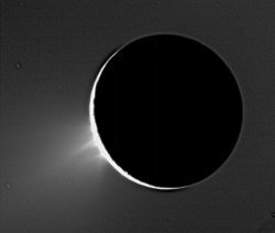
Visual confirmation of venting came in November 2005, when Cassini imaged fountain-like plumes of icy particles rising from the moon's south polar region. The plume was imaged before, in January and February 2005, but additional studies on the camera's response at high phase angles, when the sun is almost behind Enceladus, were required before they could be confirmed. The images taken in November 2005 showed the plume's fine structure, revealing numerous jets (perhaps due to numerous distinct vents) within a larger, faint component extending out nearly 500 km from the surface, thus making Enceladus the fourth body in the solar system to have confirmed volcanic activity, along with Earth, Neptune's Triton, and Jupiter's Io.
The combined analysis of imaging, mass spectrometry, and magnetospheric data suggests that the observed south polar plume emanates from pressurized sub-surface chambers, similar to geysers on Earth. Because no ammonia was found in the vented material by INMS or UVIS, which could act as an anti-freeze, such a heated, pressurized chamber would consist of nearly pure liquid water with a temperature of at least 270 K, as illustrated in Figure 13. Pure water would require more energy to melt, either from tidal or radiogenic sources, than an ammonia-water mixture. Another possible method for generating a plume is sublimation of warm surface ice. During the July 14, 2005 flyby, the Composite Infrared Spectrometer (CIRS) found a warm region near the South Pole. Temperatures found in this region range from 85-90 K, to small areas with temperatures as high as 157 K, much too warm to be explained by solar heating, indicating that parts of the south polar region are heated from the interior of Enceladus. Ice at these temperatures is warm enough to sublimate at a much faster rate than the background surface, thus generating a plume. This hypothesis is attractive since the sub-surface layer heating the surface water ice could be an ammonia-water slurry at temperatures as low as 170 K, and thus not as much energy is required to produce the plume activity. However, the abundance of particles in the south polar plume favors the "cold geyser" model, as opposed to an ice sublimation model.
Internal structure
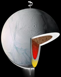
Prior to the Cassini mission, relatively little was known about the interior of Enceladus. However, results from recent flybys of Enceladus by the Cassini spacecraft have provided much needed information for models of Enceladus's interior. These include a better determination of the mass and tri-axial ellipsoid shape, high-resolution observations of the surface, and new insights on Enceladus's geochemistry.
Mass estimates from the Voyager program missions suggested that Enceladus was composed almost entirely of water ice. However, based on the effects of Enceladus's gravity on Cassini, its mass was determined to be much higher than previously thought, yielding a density of 1.61 g/cm3. This density is higher than Saturn's other mid-sized icy satellites, indicating that Enceladus contains a greater percentage of silicates and iron. With additional material besides water ice, Enceladus's interior may have experienced comparatively more heating from the decay of radioactive elements.
Castillo et al. 2005 suggested that Iapetus, and the other icy satellites of Saturn, formed relatively quickly after the formation of the Saturnian sub-nebula, and thus were rich in short-lived radionuclides. These radionuclides, like aluminium-26 and iron-60, have short half-lives and would produce interior heating relatively quickly. Without the short-lived variety, Enceladus's complement of long-lived radionuclides would not have been enough to prevent rapid freezing of the interior, even with Enceladus' comparatively high rock-mass fraction, given Enceladus' small size. Given Enceladus's relatively high rock-mass fraction, the proposed enhancement in 26Al and 60Fe would result in a differentiated body, with an icy mantle and a rocky core. Subsequent radioactive and tidal heating would raise the temperature of the core to 1000 K, enough to melt the inner mantle. However, for Enceladus to still be active, part of the core must have melted too, forming magma chambers that would flex under the strain of Saturn's tides. Tidal heating, such as from the resonance with Dione or from libration, would then have sustained these hot spots in the core until the present, and would power the current geological activity.
In addition to its mass and modeled geochemistry, researchers have also examined Enceladus's shape to test whether the satellite is differentiated or not. Porco et al. 2006 used limb measurements to determine that Enceladus's shape, assuming it is in hydrostatic equilibrium, is consistent with an undifferentiated interior, in contradiction to the geological and geochemical evidence. Further work on non-hydrostatic equilibrium models of the interior is needed to reconcile this problem.
Sky from Enceladus
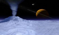
Seen from Enceladus, Saturn would have a visible diameter of almost 30°, sixty times more than the Moon visible from Earth. Moreover, since Enceladus rotates synchronously with its orbital period and therefore keeps one face pointed toward Saturn, the planet never moves in Enceladus' sky (albeit with slight variations coming from the orbit's eccentricity), and cannot be seen from the far side of the satellite.
Saturn's rings would be seen from an angle of only 0.019° and would be almost invisible, but their shadow on Saturn's disk would be clearly distinguishable. Like our own Moon from Earth, Saturn itself would show regular phases. From Enceladus, the Sun would have a diameter of only 3.5 minutes of arc, nine times smaller than that of the Moon as seen from Earth.
An observer located on Enceladus could also observe Mimas (the biggest satellite located inside Enceladus' orbit) transit in front of Saturn every 72 hours on average.
