Hurricane Ivan
2007 Schools Wikipedia Selection. Related subjects: Natural Disasters
| Category 5 hurricane ( SSHS) | ||
|---|---|---|
|
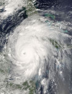
Hurricane Ivan as a Category 5. |
||
| Formed | September 2, 2004 | |
| Dissipated | September 24, 2004 | |
| Highest winds |
|
|
| Lowest pressure | 910 mbar ( hPa) | |
| Damage | $19.7 billion (2005 USD) | |
| Fatalities | 92 direct, 32 indirect | |
| Areas affected |
The Windward Islands (especially Grenada), Venezuela, Jamaica, Grand Cayman, Cuba, Alabama, Florida, and most of the eastern United States, (after rebirth) Texas, Louisiana | |
| Part of the 2004 Atlantic hurricane season |
||
Hurricane Ivan was the strongest hurricane of the 2004 Atlantic hurricane season. The storm formed as a Cape Verde-type hurricane in early September, and became the ninth named storm, the sixth hurricane, and the fourth major hurricane of the year. Ivan reached Category 5 strength on the Saffir-Simpson Hurricane Scale, the highest possible category, and it became the sixth (now ninth) most intense Atlantic hurricane on record, as well as the only Category 5 storm of the season.
Ivan caused catastrophic damage to Grenada, which it struck directly at Category 3 intensity, and heavy damage to Jamaica, Grand Cayman, and the western tip of Cuba. After peaking in strength, it moved north-northwest across the Gulf of Mexico to make landfall as a strong Category 3 storm in the United States, near Gulf Shores, Alabama, causing very heavy damage. Ivan dropped heavy rains on the Southeastern United States as it looped across Florida and back into the Gulf of Mexico. The remnant low from the storm regenerated into a new tropical system, which moved into Louisiana and Texas, causing minimal damage. Ivan caused an estimated $13 billion worth of damage in the United States, making it the fourth costliest hurricane to ever strike the United States.
Storm history

On September 2, 2004, Tropical Depression Nine formed from a large tropical wave southwest of the Cape Verde Islands. As the storm moved to the west it gradually strengthened, becoming Tropical Storm Ivan on September 3 and it reached hurricane strength on September 5, 1150 miles (1850 km) to the east of Tobago. Later that day the storm began to rapidly intensify, and by 5 p.m. EDT (2100 UTC), Ivan had become a Category 3 hurricane with winds of 125 mph (200 km/h). The National Hurricane Centre noted the rapid strengthening of Hurricane Ivan on September 5 was unprecedented at such a low latitude in the Atlantic basin.
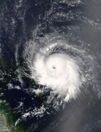
Hurricane Ivan weakened slightly as it continued to move west due to wind shear present in the area. The storm passed over Grenada on September 7, battering several of the Windward Islands as it entered the Caribbean Sea. Ivan began to rapidly intensify again and became a Category 5 hurricane just north of the Windward Netherlands Antilles and Aruba on September 9 with winds reaching 160 mph (260 km/h). Hurricane Ivan weakened slightly as it moved west-northwest, towards Jamaica. As Ivan approached the island late on September 10, it began a westward jog which kept the eye and the strongest winds to the south and west. However, because it still came very close to the Jamaican coast the island was battered with hurricane-force winds for hours.
| Most intense Atlantic hurricanes Intensity is measured solely by central pressure |
|||
|---|---|---|---|
| Rank | Hurricane | Season | Min. pressure |
| 1 | Wilma | 2005 | 882 mbar ( hPa) |
| 2 | Gilbert | 1988 | 888 mbar (hPa) |
| 3 | "Labor Day" | 1935 | 892 mbar (hPa) |
| 4 | Rita | 2005 | 895 mbar (hPa) |
| 5 | Allen | 1980 | 899 mbar (hPa) |
| 6 | Katrina | 2005 | 902 mbar (hPa) |
| 7 | Camille | 1969 | 905 mbar (hPa) |
| Mitch | 1998 | 905 mbar (hPa) | |
| 9 | Ivan | 2004 | 910 mbar (hPa) |
| 10 | Janet | 1955 | 914 mbar (hPa) |
| Source: U.S. Department of Commerce | |||
After passing Jamaica, it resumed its more northerly track, and regained Category 5 strength. Ivan's strength continued to fluctuate as it moved west on September 11 and attained its highest winds of 170 mph (275 km/h) as it passed within 30 miles (45 km) of Grand Cayman. Ivan reached its peak strength with a minimum central pressure of 910 mbar ( hPa) on September 12, making Ivan the ninth most intense Atlantic hurricane on record, as of October 2006. Hurricane Ivan passed through the Yucatán Channel late on September 13 while its eyewall affected the westernmost tip of Cuba. Once over the Gulf of Mexico, it weakened slightly to Category 4 strength, but maintained that intensity as it approached the Gulf Coast of the United States.
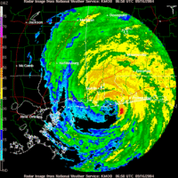
Just before it made landfall in the United States, Hurricane Ivan's eyewall weakened considerably, and its southwestern portion almost disappeared in the hours before landfall. Around 2 a.m. CDT September 16 (0700 UTC), Ivan made landfall on the U.S. mainland near Gulf Shores, Alabama as a Category 3 hurricane with 130 mph (210 km/h) winds. Ivan then continued inland, maintaining hurricane strength until it was over central Alabama. Ivan rapidly weakened that evening and became a tropical depression the same day, still over Alabama. Ivan lost tropical characteristics on September 18 while crossing Virginia and later that day the remnant low drifted off the U.S. mid-Atlantic coast into the Atlantic Ocean, and the low pressure disturbance continued to dump rain on the United States.
On September 20 a small surface low, originating from the southern remnants of Ivan, completed an anticyclonic loop and moved across the Florida peninsula. As it continued west across the northern Gulf of Mexico, the system organized and took on tropical characteristics. On September 22 the National Weather Service, "after considerable and sometimes animated in-house discussion [regarding] the demise of Ivan," determined that the low was in fact a result of the remnants of Ivan and thus named it accordingly. On the evening of September 23, the revived Ivan made landfall near Cameron, Louisiana as a weak tropical storm. Ivan finally dissipated on September 24 as it moved overland into Texas.
Records
Ivan set several new records for intensity at low latitudes.
When Ivan first became a Category 3 hurricane on September 5 (1800 UTC), it was centered near 10.2 degrees north; this is the most southerly location on record for a major hurricane in the Atlantic basin. Just six hours later, Ivan also became the most southerly Category 4 hurricane on record in the Atlantic basin when it reached that intensity while located at 10.6 degrees north. Finally, Ivan managed to become the most southerly Category 5 hurricane on record in the Atlantic basin; it achieved this at midnight (UTC) on September 9 while centered at 13.7 degrees north.
Ivan had a total ACE of 70.6, second only to the San Ciriaco Hurricane of 1899.
Ivan had 33 (32 consecutive) 6 hourly reports at category 4 strength. This record was later broken by Hurricane Ioke, which had 36 (33 consecutive) 6 hourly reports at category 4 strength.
On September 16th 2004 Hurricane Ivan created the largest "wave" of water ever recorded. Scientists from the Naval Research Laboratory at Stennis Space Centre, Mississippi, have had to employ a computer model to predict that, while they were not looking, the height of the storm the wave reached 131 ft, equivalent to the height of a 15 story building. By comparison, the tsunami wave that swept across the Indian Ocean in December 2004 stood about 30 ft high as it hit shorelines, although in some parts of Indonesia it was reported to have reached 65 ft.
Preparations
In the Caribbean, 500,000 Jamaicans were told to evacuate from coastal areas, but only 5,000 were reported to have moved to shelters. 12,000 residents and tourists were evacuated from Isla Mujeres off Yucatan.
In Louisiana, mandatory evacuations of vulnerable areas in Jefferson, Lafourche, Plaquemines, St. Charles, St. James, St. John the Baptist and Tangipahoa parishes took place, with voluntary evacuations in 6 other parishes ordered. More than one-third of the population of Greater New Orleans voluntarily evacuated, including more than half of the residents of New Orleans. At the height of the evacuation, intense traffic congestion on local highways caused delays of up to 12 hours. About a thousand special-needs patients were housed at the Louisiana Superdome during the storm. Ivan was considered a particular threat to the New Orleans area because dangers of catastrophic flooding. Thankfully, the city and the rest of the Metro Area dodged a bullet and flood walls held. However, Plaquemines and St. Bernard Parishes suffered a moderate amount of wind damage. Hurricane preparedness for New Orleans was judged poor. As had been repeated most hurricane seasons since the 1960s, at one point the media sparked fears of an "Atlantean" catastrophe if the hurricane were to make a direct strike on the city. These fears were not realized, as the storm's path turned further east. The publicity generated may have contributed to the somewhat more effective evacuation of the city in preparation for Hurricane Katrina a year later, however.
In Mississippi, evacuation of mobile homes and vulnerable areas took place in Hancock, Jackson and Harrison counties. In Alabama, evacuation in the areas of Mobile and Baldwin counties south of Interstate 10 was ordered, including a third of the incorporated territory of the City of Mobile, as well as several of its suburbs.
In Florida, a full evacuation of the Florida Keys began at 7:00 a.m. EDT September 10, but was lifted at 5:00 a.m. EDT September 13 as Ivan tracked further west than originally predicted. Voluntary evacuations were declared in ten counties along the Florida Panhandle, with strong emphasis in the immediate western counties of Escambia, Santa Rosa, and Okaloosa.
It caused "The Little Zoo That Could," located in Alabama, to evacuate 270 animals at the time which lead to much distress. The evacuation had to be done within a couple of hours...and there were only 28 volunteers that help in moving the 270 animals.
Impact
| Deaths from Hurricane Ivan | ||||||
| Country | Total | State or region | Regional total |
Direct deaths |
||
|---|---|---|---|---|---|---|
| Barbados | 1 | 1 | ||||
| Cayman Islands | 2 | 1 | ||||
| Dominican Republic | 4 | 4 | ||||
| Grenada | 39 | 39 | ||||
| Jamaica | 17 | 17 | ||||
| Trinidad and Tobago | 1 | Tobago | 1 | 1 | ||
| USA | 54 | Alabama | 5 | 0 | ||
| Connecticut | 1 | 0 | ||||
| Florida | 19 | 14 | ||||
| Georgia | 4 | 2 | ||||
| Louisiana | 4 | 0 | ||||
| Maryland | 1 | 0 | ||||
| Mississippi | 3 | 1 | ||||
| North Carolina | 10 | 8 | ||||
| Pennsylvania | 6 | 0 | ||||
| Tennessee | 1 | 0 | ||||
| Venezuela | 3 | 3 | ||||
| Totals | 121 | 91 | ||||
| Because of differing sources, totals may not match. | ||||||
| Sources: | ||||||
Ivan killed 64 people in the Caribbean—mainly in Grenada and Jamaica—three in Venezuela, and 25 in the United States, including fourteen in Florida. Thirty-two more deaths in the United States were indirectly attributed to Ivan. Tornadoes spawned by Ivan struck communities along concentric arcs on the leading edge of the storm. Blountstown, Florida, Marianna, Florida and Panama City Beach suffered three of the most devastating tornadoes. A Panama City Beach news station was nearly hit by an F2 tornado during the storm. Ivan also caused over $13 billion in damages in the United States and $3 billion in the Caribbean.
Grenada
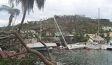
Ivan passed directly over Grenada on September 7, 2004, killing 39 people. The capital, St. George's, was severely damaged and several notable buildings were destroyed, including the residence of the prime minister. Ivan also caused extensive damage to a local prison, allowing most of the inmates to escape. The island, in the words of a Caribbean disaster official, suffered "total devastation". According to a member of the Grenadian parliament, at least 85% of the small island was devastated. Extensive looting was reported. In all, damage on the island totaled to $815 million (2004 USD).
Jamaica
On September 11–12, Ivan passed over Jamaica, causing significant wind and flood damage. Looters were reported roaming the streets of Jamaica's capital city, Kingston (which appeared deserted), robbing emergency workers at gunpoint. Overall, 17 people were killed in Jamaica and 18,000 people were left homeless as a result of the flood waters and high winds. Most of the major resorts and hotels fared well, though, and were reopened soon only a few days after Ivan had passed. Damage on Jamaica totaled to $360 million (2004 USD).
Cayman Islands
In the Cayman Islands, governor Bruce Dinwiddy described damage as "very, very severe and widespread." A quarter of buildings on the islands were reported to be uninhabitable, with 80% damaged to some extent. Much of Grand Cayman Island still remained without power, water or sewer services ten days later. After five months, barely half the pre-Ivan hotel rooms were usable. Only two people were killed on the islands. The damage totaled to $1.85 billion (2004 USD) in the Cayman Islands.
Rest of the Caribbean
Elsewhere in the Caribbean, a pregnant woman was killed in Tobago when a tree fell on top of her home, while another casualty was caused to a 75-year-old Canadian woman that drowned in Barbados. There were also four deaths in the Dominican Republic and three in Venezuela. Over one-hundred fifty homes on Barbados and around 60 homes in St. Vincent and the Grenadines were also reportedly damaged. The regions' Caribbean Development Bank estimates Ivan caused over $3 billion damage on island nations, mostly in the Cayman Islands, Grenada and Jamaica.
Even though Ivan did not make landfall on Cuban soil, its storm surge caused localized flooding on Santiago de Cuba and Granma, on the southern part of the island. At Cienfuegos, the storm produced 15 ft (5 m) waves, and at Pinar del Río, there were 339 mm (13 in) of rainfall recorded. While there were no casualties in the island, the Cuban government estimates that about 1.2 billion USD of property damage were directly due to Ivan.
United States
Along with the 14 deaths in Florida, Ivan is blamed for eight in North Carolina, two in Georgia, and one in Mississippi. There were an additional 32 deaths reported as indirectly caused by the storm.
Ivan caused an estimated $13 billion in damage in the United States alone, making it the third costliest hurricane on record at the time, being very near Hurricane Charley's $14 billion but well below Hurricane Andrew's $26 billion. Hurricane Hugo; Ivan displaced Hurricane Hugo which had previously held the third spot. In 2005, Hurricane Katrina caused $81 billion in damage, displacing Ivan to fourth place, and Hurricane Wilma caused $20 billion in damage, displacing Ivan again to fifth place.
| Costliest U.S. Atlantic hurricanes Cost refers to total estimated property damage. |
|||||||
|---|---|---|---|---|---|---|---|
| Rank | Hurricane | Season | Cost (2005 USD) | ||||
| 1 | Katrina | 2005 | $81.2 billion | ||||
| 2 | Andrew | 1992 | $44.9 billion | ||||
| 3 | Wilma | 2005 | $20.6 billion | ||||
| 4 | Charley | 2004 | $15.4 billion | ||||
| 5 | Ivan | 2004 | $14.6 billion | ||||
| Main article: List of notable Atlantic hurricanes | |||||||
Florida
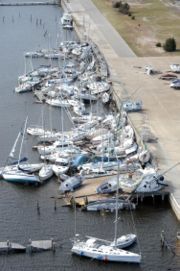
Heavy damage as Ivan made landfall on the U.S. coastline was observed in Pensacola, Pensacola Beach, dwellings situated far inland along the shorelines of Escambia Bay, East Bay, and Blackwater Bay in Escambia County and Santa Rosa County, and Fort Walton Beach, Florida on the eastern side of the storm. The area just west of Pensacola, including the community of Warrington which includes Pensacola NAS, Perdido Key, and Southwest Escambia County, took the brunt of the storm. Some of the subdivisions in this part of the county were completely destroyed, with a few key roads in the Perdido area only opened in late 2005, over a year after the storm hit. Shattered windows from gusts and flying projectiles experienced throughout the night of the storm were common. On Pensacola Beach, roads still remain closed due to damage from Ivan's storm surge.
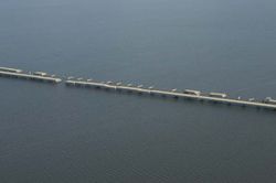
In Pensacola, the Interstate 10 bridge across Escambia Bay was heavily damaged, with as much as a quarter mile (400 m) of the bridge collapsing into the bay. The causeway that carries U.S. Highway 90 across the northern part of the same bay was also heavily damaged. Virtually all of Perdido Key, an area on the outskirts of Pensacola that bore the brunt of Ivan's winds and rain, was essentially leveled. High surf and wind brought extensive damage to Innerarity Point.
As of June 2006, more than 1,000 families are still living in FEMA-provided trailers in the Pensacola area.
Alabama
The city of Demopolis, over 100 miles inland in west-central Alabama, endured wind gusts estimated at 90 mph (150 km/h), while Montgomery saw wind gusts in the 60–70 mph (95–115 km/h) range at the height of the storm.
The heaviest damage as Ivan made landfall on the U.S. coastline was observed in Baldwin County in Alabama, where the storm's eye (and eyewall) made landfall. High surf and wind brought extensive damage to Orange Beach near the border with Florida.
Rest of the United States
Further inland, Ivan caused major flooding, bringing the Chattahoochee River near Atlanta and many other rivers and streams to levels at or near 100-year records. The Delaware River and its tributaries crested just below their all-time records set by Hurricane Diane in 1955.
In Western North Carolina, many streams and rivers reached well above flood stage causing many roads to be closed. The Blue Ridge Parkway as well as Interstate 40 through the Pigeon River gorge in Haywood County, North Carolina, sustained major damage.
The system also spawned deadly tornadoes as far north as Maryland, and destroyed seven oil platforms in the Gulf of Mexico while at sea. While crossing over the Mid-Atlantic states, Ivan's remnants spawned over 100 tornadoes over the southeastern U.S. and 26 tornadoes in the Washington, D.C. and Southern Maryland area alone. Ivan then moved into the Pittsburgh area, causing major flooding. Pittsburgh International Airport recorded the highest 24-hour rainfall for Pittsburgh, recording 5.95 in. of rain.
After Ivan regenerated in the Gulf of Mexico, it caused further heavy rainfall up to 8 inches (20 cm) in areas of Louisiana and Texas.
Canada
On the morning of September 21, the remnant mid-level circulation of Ivan combined with a frontal system. This produced a plume of moisture over the Canadian Maritimes for four days, producing heavy rainfall totaling to 6.2 (158 mm) inches in Gander, Newfoundland. High winds of up to 89 mph (143 km/h) downed trees and caused power outages in Newfoundland, Prince Edward Island, and eastern Nova Scotia. The system produced intense waves of up to 50 feet (15 m) near Cape Bonavista. The system killed two when it grounded a fishing vessel, and was indirectly responsible for 4 traffic fatalities in Newfoundland.
Aftermath
Grenada
Grenada suffered serious economic repercussions following the destruction caused by Ivan. Before Ivan, the economy of Grenada was projected to grow by 4.7%, but the island's economy instead contracted by nearly 3% in 2004. The economy was also projected to grow by at least 5% through 2007, but, as of 2005, that estimate had been lowered to less than 1%. The government of Grenada also admitted that the government debt—130% of the island's GDP—was "unsustainable" in October 2004, and appointed a group of professional debt advisors in January 2005 to try to alleviate the situation.
More than $150 million was sent to Grenada in 2004 to aid reconstruction following Ivan, but the economic situation remains fragile. The IMF reports that as "difficult enough as the present fiscal situation is, it is unfortunately quite easy to envisage circumstances that would make it even more so." Furthermore, "shortfalls in donor financing and tax revenues, or events such as a further rise in global oil prices, pose a grave risk."
United States
Hurricane Ivan is suspected of bringing spores of soybean rust from Venezuela into the United States, the first ever occurrences of soybean rust found in North America. Since the Florida soybean crop had already been mostly harvested, economic damage was limited. Some of the most severe outbreaks in South America have been known to reduce soybean crop yields by half or more.
Retirement
This storm also marked the third occasion the name "Ivan" had been used to name a tropical cyclone in the Atlantic, as well as the fourth occurrence worldwide. The name Ivan was retired in the spring of 2005 by the World Meteorological Organization and will never again be used in the Atlantic basin. It was replaced by Igor for the 2010 season.
