Hurricane Charley
2007 Schools Wikipedia Selection. Related subjects: Natural Disasters
| Category 4 hurricane ( SSHS) | ||
|---|---|---|
|
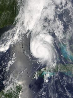
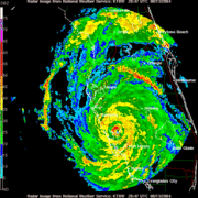
Hurricane Charley at landfall in Florida. |
||
| Formed | August 9, 2004 | |
| Dissipated | August 14, 2004 | |
| Highest winds |
|
|
| Lowest pressure | 941 mbar ( hPa) | |
| Damage | $16 billion (2004 USD) $16.4 billion (2005 USD) |
|
| Fatalities | 15 direct, 20 indirect | |
| Areas affected |
Jamaica, Cayman Islands, Cuba, Florida, South Carolina, North Carolina | |
| Part of the 2004 Atlantic hurricane season |
||
Hurricane Charley was the third named storm, the second hurricane, and the second major hurricane of the 2004 Atlantic hurricane season. Charley lasted from August 9 to August 14, peaking as a 150 mph (240 km/h) Category 4 hurricane on the Saffir-Simpson Hurricane Scale. The hurricane made landfall in southwestern Florida at peak intensity, the strongest hurricane to hit the United States since Hurricane Andrew twelve years prior.
After moving briskly through the Caribbean Sea, Charley crossed Cuba as a Category 3 hurricane, causing heavy damage and 4 deaths. On August 13, the hurricane crossed over the Dry Tortugas, just 22 hours after Tropical Storm Bonnie struck northwestern Florida. This was the first time in history that two tropical cyclones struck the same state in a 24 hour time period. Charley was one of two major hurricanes to hit Florida in 2004 and one of four hurricanes to directly affect the state.
At its peak intensity of 150 mph (240 km/h) Hurricane Charley struck the northern tip of Captiva Island and the southern tip of North Captiva Island, causing severe damage. The strongest hurricane to hit the area since Hurricane Donna in 1960, Charley continued to produce severe damage as it made landfall near Port Charlotte. The hurricane continued to the northeast, and passed through East Orlando while retaining wind gusts of up to 106 mph. Damage in the state totaled to over $13 billion (2004 USD). Charley, initially expected to hit further north in Tampa, caught many Floridians off-guard from a sudden change of track to the northeast. Throughout the United States, Charley caused 10 casualties and $15 billion in damage (2004), making Charley the fourth costliest hurricane in United States history.
Storm history
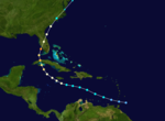
Charley began as a tropical wave that moved off the coast of Africa on August 4. It moved quickly westward and steadily organized, with convection developing in curved bands. The wave continued to organize as it approach the Lesser Antilles, and it developed into Tropical Depression Three on August 9 while 115 miles south-southeast of Barbados. Low upper-level shear and well-defined outflow contributed to further development, and the depression intensified into Tropical Storm Charley on August 10 in the typically unfavorable eastern Caribbean Sea.
A strong ridge of high pressure to the system's north forced Charley to track quickly to the west-northwest. Steady strengthening continued, and Charley intensified into a hurricane on August 11 while 90 miles (150 km) south of Kingston, Jamaica. The hurricane moved around the periphery of high pressure, and its track turned to the northwest. On August 12, Charley passed just south of Jamaica, then passed 17 miles northeast of Grand Cayman as a Category 2 hurricane. The hurricane continued to strengthen as it turned to the northwest, and hit southern Cuba near Playa del Cajio as a 120 mph (190 km/h) major hurricane on the 13th. Charley weakened while crossing the island, and passed just west of downtown Havana before weakening to a 110 mph (180 km/h) hurricane.
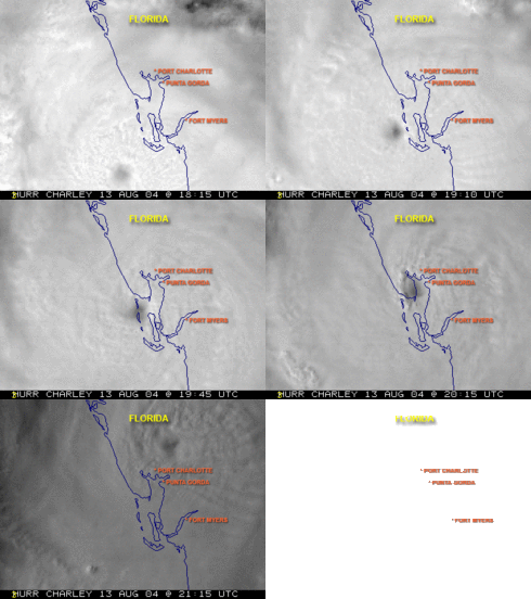
Hurricane Charley accelerated to the north-northeast in response to the approach of an unseasonal mid-tropospheric trough, resulting in the hurricane passing over the Dry Tortugas on August 13. This occurred 22 hours after Tropical Storm Bonnie, the first time two tropical cyclones hit the same state in a 24 hour period . Charley rapidly intensified, strengthening from a 110 mph (180 km/h) hurricane with a pressure of 965 mbar to a 145 mph (230 km/h) hurricane with a pressure of 941 mbar in just 6 hours. The hurricane continued to intensify as it turned more to the northeast, and Charley made landfall near the island of Cayo Costa, Florida as a 150 mph (240 km/h) hurricane on the 13th. An hour later, the hurricane struck Port Charlotte as a 145 mph (230 km/h) hurricane.
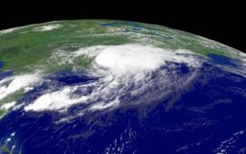
Charley weakened slightly over land, but still retained sustained winds of well over 85 mph as it passed directly over Orlando between 8:20 and 9:40 p.m. on August 13; gusts of up to 106 mph were recorded at Orlando International Airport. The hurricane emerged into the Atlantic Ocean near Daytona Beach, Florida as a minimal hurricane, but restrengthened slightly over open waters. Continuing to move rapidly to the north-northeast, Charley struck near Cape Romain, South Carolina, moved offshore briefly, and made landfall again near North Myrtle Beach as a minimal hurricane. Charley interacted with an approaching frontal boundary, and the storm became extratropical after exiting into the Atlantic Ocean near Virginia Beach on August 15. The extratropical storm continued to move to the northeast, and was absorbed by the front later on the 15th near southeastern Massachusetts.
Preparations
On August 10, 2 days before the hurricane passed by the area, Jamaican governmental officials issued a Tropical Storm Warning, which was upgraded to a hurricane warning a day later. In Jamaica, the threat of the storm forced the country's two airports to close and rerouted two cruise ships. The Cayman Islands issued a hurricane warning on the 11th, a day before the hurricane passed near the area.
Cuban government officials issued a Hurricane Watch for the southern coastline on August 11, two days before the hurricane struck the island. This was upgraded to a hurricane warning on the 12th, 13 ½ hours before Charley made landfall. Because of the threat, the government issued a mandatory evacuation for 235,000 citizens and 159,000 animals in the area of expected impact. 3,800 were evacuated from offshore islands, while 47,000 in Havana were transported from old, unsafe buildings to safer areas. The people were transported to shelters with supplies there. In addition, the power grid in southern Cuba was turned off to avoid accidents.
The National Hurricane Centre issued Hurricane warnings for the Florida Keys and from Cape Sable to the mouth of the Suwannee River a day prior to Charley passed through the area, while tropical storm warnings were issued elsewhere throughout Florida. Because of the threat, 1.9 million people along the Florida west coast were urged to evacuate , including 380,000 residents in the Tampa Bay area and 11,000 in the Florida Keys. . It was the largest evacuation order for Pinellas County history , and the largest evacuation request in Florida since Hurricane Floyd five years prior. Many Floridians, estimated from about 400,000 to 800,000, remained despite the evacuation order. They boarded up their home and bought supplies to ride out the storm. Power companies mobilized workers to prepare for the expected widespread power outages. MacDill Air Force Base, the U.S. military centre for the War on Iraq, severely limited its staff. Similarly, Kennedy Space Centre, which usually has a staff of 13,000, reduced its staff to only 200 people in preparation for the hurricane. All space shuttles were sealed tight in hangars. Many amusement parks in the Orlando area closed early, while Walt Disney World's Animal Kingdom remained closed. This was the only the second time in history after Hurricane Floyd that a Disney park was closed due to a hurricane. The approaching hurricane also forced several cruise ships to reroute their paths.
The rapid strengthening of Charley in the eastern Gulf of Mexico caught many by surprise. Around five hours before its actual landfall, Charley was a strong Category 2 hurricane predicted to strengthen to a 115 mph (185 km/h) hurricane with a landfall in the Tampa- Saint Petersburg, Florida area. Around two hours before its actual landfall, the National Hurricane Centre issued a special advisory with Charley as a 145 mph (230 km/h) Category 4 hurricane with predicted landfall in the Port Charlotte area. As a result, numerous people in the Charlotte County area were unprepared for the hurricane, despite the fact that the track was well within the forecast's margin of error. National Hurricane Centre forecaster intern Robbie Berg publicly blamed the media for misleading residents of a Tampa landfall. In addition, he also stated that residents had ample warning , as a Hurricane Warning existed for the landfall area for 23 hours with a Hurricane Watch for 35 hours.
Several local meteorologists, however, did break with national news predictions of a Tampa Bay landfall as early as Friday morning. Robert Van Winkle of WBBH and Jim Reif of WZVN in Fort Myers, and Tom Terry of WFTV in Orlando, all broke with their national news forecasts and stated at around 11am EDT that Charley was going to turn early, striking around Charlotte Harbour and travelling over Orlando . This was its eventual course.
In South Carolina, Governor Mark Sanford declared a state of emergency as Charley neared its final landfall. Two coastal counties were forced to evacuate, with state troopers redirecting traffic further inland from Myrtle Beach. In all, 138,000 evacuated from the Grand Strand area.
Impact
| Region | Direct | Indirect | Total |
|---|---|---|---|
| Jamaica | 1 | 0 | 1 |
| Cuba | 4 | 0 | 4 |
| Florida | 9 | 20 | 29 |
| Rhode Island | 1 | 0 | 1 |
| Total | 15 | 20 | 35 |
| Costliest U.S. Atlantic hurricanes Cost refers to total estimated property damage. |
|||||||
|---|---|---|---|---|---|---|---|
| Rank | Hurricane | Season | Cost (2005 USD) | ||||
| 1 | Katrina | 2005 | $81.2 billion | ||||
| 2 | Andrew | 1992 | $44.9 billion | ||||
| 3 | Wilma | 2005 | $20.6 billion | ||||
| 4 | Charley | 2004 | $15.4 billion | ||||
| 5 | Ivan | 2004 | $14.6 billion | ||||
| Main article: List of notable Atlantic hurricanes | |||||||
One death in Jamaica, four deaths in Cuba, and ten deaths in the United States were directly attributed to Charley. Numerous injuries were reported, as well as twenty indirect deaths in the U.S.
Property damage from Charley in the United States was estimated by the NHC at $15 billion ( 2004 USD) . This made Charley the second costliest hurricane in United States history behind Hurricane Andrew's $43.7 billion in the 1992 season, though has since dropped to forth due to the 2005 season's Hurricane Katrina and Hurricane Wilma.
Caribbean Sea
On Jamaica, strong winds caused moderate damage to the agricultural sector, with crop and livestock damage totaling to $1.44 million (2004 USD) Damage was heaviest in Saint Elizabeth Parish, where 100 people had to be housed in six shelters. Strong winds downed trees and power lines, causing power outages and blocking roads. In the country, Charley caused $4.1 million (2004 USD) in damage and one fatality. Charley greatly spared the Cayman Islands, resulting in little damage. Rainfall was light, peaking at .9 inches in Grand Cayman, while Cayman Brac reported tropical storm force winds.
Operationally, forecasters estimated that Charley struck southern Cuba as a 105 mph (170 km/h) Category 2 hurricane on the Saffir-Simpson scale In post-analysis, Charley struck southern Cuba as a 120 mph (190 km/h) hurricane, based on a report of 118 mph in Playa Baracoa. The hurricane produced a storm surge of up to 13.1 feet (4 meters) in Playa Cajio, while Charley's quick passage dropped light rainfall totaling to 5.87 inches (149 mm) in Mariel.
Strong wind gusts downed nearly 1,500 power lines and knocked over 28 large, high tension wire towers at a power plant in Mariel. As a result, more than half of power customers in Havana Province were without power by 12 days after the storm, and all of Pinar del Rio Province was without power for over 11 days. Blackouts continued in areas where power returned. The power outages resulted in lack of water for numerous people, including no water in the city of Havana for four days. As a result, the Cuban government sent water tanks to satisfy the short term need. Similarly, there was a lack of gas for cooking for over a week. However, one Cuban government official stated that it could take up to two months for basic utilities to be returned to many isolated villages.
Near its landfall location, Charley destroyed 290 of the 300 houses in the village, while over 70,000 homes in Havana were either damaged or destroyed. Numerous hotels reported damage, potentially impacting the important tourism industry in the country. Agricultural damage was heavy, with the hurricane damaging more than 3,000 agricultural institutions. Citrus officials estimated a loss of 15,000 metric tons of grapefruit on the Isle of Youth, while strong winds ruined 66,000 metric tons off citrus trees in the Havana area. Charley also destroyed around 57,000 acres of fruit trees in the Havana area. In all, Charley caused four deaths on Cuba and $923 million (2004 USD) in damage, primarily from agricultural losses.
Florida
While moving northward to the west of the Florida Keys, Charley produced moderate winds of 48 mph (77 km/h) with gusts to 60 mph (97 km/h) in Key West. The winds downed a few trees, power lines, and unreinforced signs. A boat knocked loose by strong waves struck a power transmission line, causing widespread power outages from Marathon to Key West. On Fort Jefferson in the Dry Tortugas, the hurricane produced an estimated storm surge of up to 6 feet (2 meters). The surge, combined with waves, caused extensive flooding in the park and damaged numerous docks. Damage was minimal in the area, totaling to $160,000 (2004 USD).
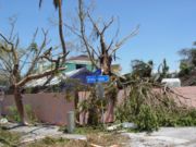
Hurricane Charley passed directly over Captiva Island near Cayo Costa with peak winds of 150 mph. The Category 4 hurricane produced an estimated storm surge of up to 6.5 feet (2 m) on the island, a lower than expected amount due to the hurricane's small size. The storm surge, combined with the strong pressure gradient, produces a 1/4 mile (450 m) inlet on North Captiva Island, known as Charley's Cut. Strong waves and storm surge caused severe beach erosion and dune damage at various different locations. The storm severely damaged five houses, lightly damaged many others, and downed many trees on Gasparilla Island. At least half of the 300 homes on North Captiva Island were substantially damaged, including 10 that were destroyed. On Captiva Island the strong winds severely damaged most houses on the island, as well as several recreational buildings. Throughout the rest of the islands in Sarasota, Charlotte, Lee, and Collier counties, strong winds from Hurricane Charley caused severe damage to hundreds of buildings and trees.
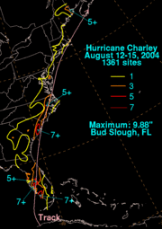
On mainland Florida, Charley produced a storm surge peaking at 10-13 feet (3-4 meters) at Vanderbilt Beach near Naples, along with a much lower surge at its Punta Gorda landfall. The hurricane dropped generally light rainfall across Florida, peaking at 9.88 inches (251 mm) in Bud Slough in Sarasota County. In Punta Gorda, where the hurricane made landfall, winds were measured up to 90 mph with gusts of up to 111 mph (180 km/h) before the instrument failed. Unofficially, the Charlotte County Medical Center recorded a peak wind gust of 172 mph (277 km/h). Due to the compact nature of the hurricane, peak winds in the storm only extended a short distance from its centre. Fort Myers, which is only 25 miles (38 km) from where Charley made landfall, experienced sustained winds of only 61 mph (98 km/h) with gusts of 78 mph (125 km/h). In South Florida, Charley spawned several tornadoes, including a long-lived F2 that struck Clewiston and five weak tornadoes near where the hurricane made landfall.
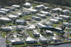
The worst damage from Hurricane Charley occurred in Charlotte County. In Boca Grande, numerous houses sustained extensive roof damage, while thousands of trees and power lines were uprooted or snapped. In Port Charlotte and Punta Gorda, many buildings, RVs, and mobile homes were completely destroyed, while other buildings were uproofed due to the powerful winds.
Charley devastated Southwest Florida, causing $14.6 billion in damages on the peninsula of Florida alone. Many towns such as Punta Gorda and Port Charlotte were simply leveled by the hurricane. Trailer parks were obliterated as far as Orlando, and trees and utility poles were downed as far as Daytona Beach.
Other Florida school systems were also severely disrupted: Orange County Public Schools opened their doors on August 9, 2004, only to close them on August 12 as Charley approached from the southwest. Damage was so extensive that schools remained closed to students until August 24, only to close again after Hurricane Frances and Hurricane Jeanne. The storm resulted in several non-federal built-in holidays being cancelled, and the tradition of releasing students one hour early on Wednesday being cancelled for the rest of the year to make up for over two weeks of lost class time.
The storm cut off power to as many as two million people in Florida. One week after landfall it was estimated that about 240,000 were still without power.
Public schools in some counties in the path of the hurricane were scheduled to be closed for two weeks. In some areas this was necessary because the school buildings were damaged or destroyed (especially in Charlotte County). In other parts of Florida, no power or water was yet available.
Agricultural losses were heavy. In Florida, the second-largest producer of oranges in the world, damage to the citrus crop was estimated at $150 million, perhaps as much as 25% of the total crop. Other crops and agricultural buildings and equipment also suffered.
Due to its path across the central part of the Florida peninsula, Charley is sometimes referred to as the " I-4 Hurricane."
Rest of United States
Upon making landfall on northeastern South Carolina, Charley unofficially produced a storm tide of up to 7.19 feet (2.19 meters) in Myrtle Beach. Wind gusts were moderate, peaking at 60 mph (95 km/h) in North Myrtle Beach, though there were several unofficial hurricane force gusts. Charley produced moderate rainfall along its path, peaking at over 7 inches (178 mm). Moderate winds knocked down numerous trees. Flash flooding occurred in Charleston County, causing drainage problems. Damage in South Carolina totaled to $20 million (2004 USD).
In North Carolina, Charley produced an estimated storm surge of 2 to 3 feet (.5-1 meters), along with waves of up to 8 feet (2.5 meters) in height. This produced minor beach erosion along the coastline. Winds gusted from 60 to 70 mph (95 to 110 km/h), causing minor wind damage. Rainfall was moderate, ranging from 4 to 6 inches (100 to 150 mm), causing flooding across 7 North Carolina counties. The hurricane spawned five weak tornadoes across the state, including an F1 in Nags Head that damaged twenty structures. Charley destroyed 40 houses and damaged 2231, 231 severely, including 221 damaged beach homes in Sunset Beach. Damage was greatest in Brunswick County, where wind gusts peaked at 85 mph (137 km/h). Crop damage was severe in Brunswick County, with 50% of the tobacco crop lost and 30% of the corn and vegetable fields destroyed. Strong winds downed trees and power lines, leaving 65,000 without power. Damage in North Carolina totaled to $25 million (2004 USD).
Tropical Storm Charley produced wind gusts of up to 72 mph (116 km/h) at Chesapeake Light, causing scattered power outages. Rainfall was light, ranging from 2 to 3.7 inches (50 to 94 mm). Charley produced one tornado in Chesapeake and one in Virginia Beach. In Rhode Island, one man drowned in a rip current.
Aftermath
President George W. Bush declared Florida a federal disaster area. He also said "...the job of the federal government and the state government is to surge resources as quickly as possible to disaster areas. And that's exactly what's happening now. We choppered over and saw the devastation of this area. A lot of people's lives are turned upside down. We've got ice and water moving in, trailers for people...are moving in. The state is providing security...There's a lot of compassion moving in the area, the Red Cross is here."
Retirement
Because of its effects in the United States, the name Charley was retired in the spring of 2005 by the World Meteorological Organization and will never again be used for an Atlantic hurricane. The name was replaced by Colin for the 2010 season.
