Philadelphia
2007 Schools Wikipedia Selection. Related subjects: North American Geography
| City of Philadelphia | |||
 |
|||
|
|||
| Nickname: "City of Brotherly Love", "Philly", "the City That Loves You Back," "the Quaker City", "The Birthplace of America"" | |||
| Motto: "Philadelphia maneto" - "Let brotherly love continue" | |||
 |
|||
| Coordinates: | |||
|---|---|---|---|
| Country | United States | ||
| State | Pennsylvania | ||
| County | Philadelphia | ||
| Founded | October 27, 1682 | ||
| Incorporated | October 25, 1701 | ||
| Mayor | John F. Street ( D) | ||
| Area | |||
| - City | 369.4 km² (142.6 sq mi) | ||
| - Land | 349.9 km² (135.1 sq mi) | ||
| - Water | 19.6 km² (7.6 sq mi) | ||
| - Urban | 4,660.7 km² (1,799.5 sq mi) | ||
| - Metro | 11,989 km² (4,629 sq mi) | ||
| Elevation | 12 m (39 ft) | ||
| Population | |||
| - City (2005) | 1,463,281 | ||
| - Density | 4,201.8/km² (10,882.8/sq mi) | ||
| - Urban | 5,325,000 | ||
| - Metro | 5,823,233 | ||
| Time zone | EST ( UTC-5) | ||
| - Summer ( DST) | EDT ( UTC-4) | ||
| Website: http://www.phila.gov | |||


Philadelphia is the largest city in Pennsylvania. The city is colloquially referred to as Philly, and known as The City of Brotherly Love (from Greek: Φιλαδέλφεια, /fi.la.ˈdɛl.fɛj.a/, "brotherly love" from philos "loving" and adelphos "brother"). It is the fifth most populous city in the United States and the largest in population and area in Pennsylvania.
The population of the city (at the 2000 census) was 1,517,550 though 2005 U.S. Census estimates a population of 1,463,281. Philadelphia is the second-largest city on the U.S. East Coast, and a major commercial, educational, and cultural centre for the nation. Philadelphia is only 46 miles from the southwestern fringe of New York City (while the downtowns are approximately 80 miles apart).
The Philadelphia metropolitan area is the fourth largest in the U.S. by the current official definition, with some 5.8 million people.
Philadelphia is one of the oldest and most historically significant cities in the United States. During part of the 18th century, the city was the first capital and most populous city of the United States, and the second largest English speaking city in the world after London. At that time, it eclipsed Boston and New York City in political and social importance, with Benjamin Franklin taking a large role in Philadelphia's rise.
History
Colonial
Before Europeans arrived, the Delaware (Lenape) Indian town of Shackamaxon was located where Philadelphia now stands, specifically the Germantown neighbourhood. Although the area lay within the bounds described in the 1632 Charter of Maryland, the Calvert family's influence never reached this far north, and the first European settlers were mostly Swedes (see New Sweden), who called it Wiccacoa. A congregation was formed in 1646 on Tinicum Island by Swedish missionary Johannes Campanius; in 1700, the group built Gloria Dei Church, also known as Old Swedes'.
Philadelphia is a planned city, founded and developed in 1682 by William Penn, a Quaker. The city's name means "brotherly love" in Greek (Φιλαδέλφια). Penn hoped that the city, as the capital of his new colony founded on principles of freedom and religious tolerance, would be a model of this philosophy. During early immigration by Quakers and others, immigrants who purchased land in the city also received farmland outside the city; this was intended to allow the population to leave the city easily. Penn also mandated the construction of alleyways and open spaces, in the hope of controlling fires and disease, which were then common problems in London and other major cities.
New Nation

Philadelphia was a major centre of the independence movement during the American Revolutionary War. The Declaration of Independence and US Constitution were drafted here and signed in the city's Independence Hall. Tun Tavern in the city is traditionally regarded as the location where, in 1775, the United States Marine Corps was founded.
During the American Revolutionary War Philadelphia's population was split between Loyalists and Patriots. When the British Army took the city in 1777 many Loyalists lined the streets and sang 'God Save the King'. Upon the retaking of the city for the American cause in 1778 it was the turn of the Patriot population to line the streets in celebration, especially as the population had suffered through a bitter winter with many of the provisions going to the British Army. The British left a mess, says historian Allan Nevins:
| The enemy had left the neatest, cleanest, best-built town in America shockingly dirty and unkempt, had destroyed public and private buildings, had cut down trees and fences, and had filled the streets and gutters with obstructions. In the outskirts and in Germantown were the marks of battle. Most of the fine old country seats surrounding the city had been destroyed--the British had fired seventeen in one day. New-piled mounds in Washington Square showed where the bodies of Continental soldiers, maltreated and starved in their prison by the brutal jailer Cunningham, had been roughly buried". |
About 3000 Loyalists fled with the British; 45 Loyalists who remained behind were put on trial for treason for consorting with the enemy in wartime. Two were convicted, and hung.
For a time in the 18th century, Philadelphia was the largest city north of Mexico City, and the fourth largest under the rule of the British crown (after London, Bristol, and Dublin).
In 1790, as the result of a compromise between a number of Southern congressmen and Alexander Hamilton, then Secretary of the Treasury, the seat of the United States Government was moved from Federal Hall in New York to Congress Hall in Philadelphia, before assuming its current site in Washington, DC. In exchange for locating a permanent capital on the banks of the Potomac, the congressmen agreed to support Hamilton's financial proposals. Philadelphia served as capital for a decade, until 1800, when the Capitol building in the new federal city of Washington, DC was opened.
19th century expansion
The city limits have been coterminous with Philadelphia County since The Act of Consolidation, 1854. Until then, the city consisted only of the area bounded by South and Vine Streets and the Delaware and Schuylkill Rivers. The expansion incorporated present-day West Philadelphia, South Philadelphia, North Philadelphia, and Northeast Philadelphia, as well as Germantown and many smaller communities.
An early railroad centre, Philadelphia was the original home of the Baldwin Locomotive Works, the world's largest builder of steam locomotives (which eventually relocated to nearby Eddystone, Pennsylvania). The Pennsylvania Railroad, once America's largest railroad by revenue and traffic volume and at one time the largest public corporation in the world, was headquartered in the city, as was its merger successor, the Penn Central, and in turn its freight railroad successor, Conrail.
In 1876 Philadelphia hosted the World's Fair, known as the Centennial Exposition. Memorial Hall and the expansive mall in front of it are remnants of this fair.
The 20th Century
In 1926, the city held the Sesquicentennial Exposition to celebrate the nation's 150th birthday.
In 1976, Philadelphia was one of the participating cities in the United States Bicentennial observances that took place nationwide.
In 1985 Philadelphia police bombed the Cobbs Creek section of West Philadelphia in order to combat a radical group known as MOVE. City officials allowed the fire to burn until it had consumed 62 area homes and left 11 dead.

Innovation
Philadelphia has been the home of several notable innovations for modern American society. While there have been many more, the following is a list of some of the national firsts that have happened in this city:
|
|
|
Geography

According to the United States Census Bureau, the city has a total area of 369.4 km² (142.6 mi²). 349.9 km² (135.1 mi²) of it is land and 19.6 km² (7.6 mi²) of it (5.29%) is water. Bodies of water include the Delaware River, Schuylkill River, Cobbs Creek, Wissahickon Creek, and Pennypack Creek.
The lowest point in the city lies 10 feet above sea level near Fort Mifflin in Southwest Philadelphia at the convergence of the Delaware and Schuylkill Rivers. The highest point is in Chestnut Hill, at 432 feet above sea level, near Evergreen Place, just north and west of Evergreen Avenue.
The counties adjacent to Philadelphia are Montgomery County to the north; Bucks County to the northeast; Burlington County, New Jersey to the east; Camden County, New Jersey to the southeast; Gloucester County, New Jersey to the south; and Delaware County to the west.
Climate
Philadelphia's climate is considered to fall in the humid subtropical climate zone, although it is perhaps the northernmost city in the United States that meets this classification. Because Philadelphia is on the far northern end of this climate zone, some of its outlying suburbs, especially to the north and west, are considered to fall in the humid continental zone. Summers are typically hot and muggy, fall and spring are generally mild, and winter is cold, although infrequently very cold. Precipitation is almost uniformly distributed throughout the year.
January lows average 25 °F (-4 °C) and highs average 39 °F (4 °C). The lowest officially recorded temperature was -11 °F (-24 °C) on February 9, 1934, but temperatures below 14 °F are not common. July lows average 70 °F (21 °C) and highs average 86° F (30 °C), although heat waves see highs above 95 °F (35 °C) with the heat index running as high as 110 °F (43 °C). The highest temperature on record was 106 °F (41 °C) on August 7, 1918. Early fall and late winter are generally driest, with February being the driest month with only 2.74 in (69.8 mm) of average precipitation.
Snowfall is variable, with some winters bringing light snow and others bringing many significant snowstorms. It is common for the heavier snowfall to occur north and west of the city, where the climate is slightly colder. Rainfall is generally spread throughout the year, with eight to eleven wet days per month, at an average annual rate of 42 in (1068 mm).
Cityscape

Penn's surveyor, Thomas Holme, laid out the city in a strict grid, with streets running either north-south or east-west. The north-south streets are numbered in ascending order from Front (instead of First), along the Delaware River, with the main north-south thoroughfare, Broad Street (instead of 14th) running midway between the two rivers. The east-west streets, many of them named for trees, e.g., Chestnut, Walnut, Locust, and Spruce parallel the main thoroughfare named High Street by Penn, but called Market Street since at least the early 18th century. Six blocks south of Market is South Street, the original southern boundary of the city. Vine Street, three blocks north of Market, was the original northern boundary.

Holme also planned five public parks, one at the intersection of High and Broad Streets in the very centre of the city, now occupied by City Hall, and four others surrounding it now called Washington Square, Rittenhouse Square, Logan Square and Franklin Square. The eastern edge of Rittenhouse Square is on 18th St., four blocks west of City Hall, while the western edge of Washington Square is between 7th and 8th, about six and a half blocks east of City Hall. Both are the same distance south of City Hall. Both Logan Square and Franklin Square are located the same distances east and west of City Hall as Washington and Rittenhouse and two to three blocks north of Market Street, reflecting the southern squares. Fairmount Park is one of the largest municipal public parks in the world, at over 9,100 acres (37 km²). This figure includes all parkland within the city limits, as all 65 city parks are considered part of Fairmount Park and overseen by the Fairmount Park Commission, but the park proper, which runs north/south through the city, does occupy nearly half that area, at over 4,100 acres (17 km²) on both banks of the Schuylkill River and Wissahickon Creek.
The post-World War II era would see further changes. Under the leadership of Edmund N. Bacon, the Philadelphia City Planning Commission organized a master plan for the city, creating a variety of special planning, redevelopment, development districts and areas to coordinate their efforts. Projects that were headed by the new master plan were major redevelopment of Center City, including the Penn Centre Area (replacing an immense, elevated railroad connector, locally known as the "Chinese Wall," located north of Market and West of Broad), Market East and Penn's Landing; new development and expansion in University City (focused mainly on the University of Pennsylvania); as well as the opening up of development on the fringes of the city, the Far Northeast and South Philadelphia Sports Complex. One of his enduring innovations is a group of small, semi-enclosed parks in the Society Hill residential area, connected by brick footpaths.
Bacon's efforts would also see changes in the transportation of the city, with the inclusion of the Centre City Rail Connector, Vine Street Expressway, Delaware Expressway, and improvements to the Schuylkill Expressway. Many of Bacon's ideas, though not entirely as he had envisioned, can be seen today, with the basis of his master plan still influencing development in the city.
Buildings and architecture

Philadelphia's architectural history dates back to Colonial times and has included a wide range of styles, sometimes showcased within a range of several blocks. Most of the city's historic landmarks are in Old City and the Historical District in the Society Hill neighborhood east of Centre City, including Independence National Historical Park, home of Independence Hall and the Liberty Bell.
For almost a century, Philadelphia's most visible structure was its baroque City Hall building and William Penn tower. Begun in 1871, City Hall took 30 years to complete and is the tallest masonry load-bearing structure in the world at 548 feet, including the statue of William Penn at its crown.
The former headquarters of the Philadelphia Savings Fund Society (PSFS), at the corner of 12th and Market Streets, erected in 1932, is widely considered the nation's first International Modernist skyscraper. The building was designed by Swiss-American architect William Lescaze and his partner George Howe. The building is a National Historic Landmark. In 1997, the building was purchased by the Loews Corporation, and in April 2000 it reopened as the Loews Philadelphia Hotel. The signature PSFS sign, however, is considered an integral part of the historic architectural design and remains atop the building.
Notable historic structures demolished in recent years include the Philadelphia Civic Centre and Philadelphia Naval Hospital (both commonly regarded as masterpieces of 1930's Art Deco architecture), JFK Stadium, a historic 1920's era athletic venue, and the Philadelphia Commercial Museum, an 1890's neoclassical exhibit hall. Other important historic sites, including the Philadelphia Metropolitan Opera House, and even the famous Philadelphia Museum of Art and Philadelphia City Hall, have suffered from decades of neglect and poor upkeep. A complete exterior cleaning of City Hall is nearing completion, and renovations, expansion and repairs are planned at the Museum of Art.
Urban abandonment in the central city and extensive sprawl in the suburbs has been a serious problem since the 1970's. By the 1990's there were an estimated 40,000 vacant properties in the city . Since then organizations and city agencies have been working to reverse this trend. Recently the city and several non-profit organizations put together an international competition, called LandVISIONS seeking solutions to the vacancy problem.
Since the 1980s, modern skyscrapers have been erected west of City Hall eclipsing Penn's statue. As of 2006, the tallest structures are One and Two Liberty Place. In 2007, the Comcast Centre, upon its expected completion, will become the tallest building in Philadelphia. Currently, thirteen skyrises, residential and commercial, are under construction, six have begun prep work, and seventeen are still in planning. Also nine skyrises are currently under renovation, and seven more are still in planning. Many of these projects will include multiple skyrises, adding to the number of actual buildings. Another seven cultural and commercial projects have begun, which consist of a slot facility, turning the Philadelphia Naval Yard into a suburban style business park with urban amenities, new parks, educational towers, state of the art schools, and others. Another ten are in planning.
Most of the city's residential neighborhoods are rowhouse communities, noted for streets lined with attached, single-family homes. Newer duplexes and single homes, as well as some older mansions and estates, are more common in the city's outskirts.
Neighborhoods
Philadelphia has many neighborhoods, each of which has its own identity. Many of these neighborhoods coincide with the borough and townships that made up Philadelphia County before their absorption by the city. These include Chestnut Hill, East Falls, Fishtown, Lawncrest, Fox Chase, Frankford, Germantown, Grays Ferry, Kensington, Manayunk, Mount Airy, North Philadelphia, Northern Liberties, Olney, Overbrook, Parkside, Parkwood, Port Richmond, Powelton Village, Queen Village, Roxborough, South Philadelphia, University City, West Oak Lane, and many others. Prominent neighborhoods in Centre City include Chinatown, Fairmount, Old City, Rittenhouse Square, Washington Square West and Society Hill.
Suburbs
Philadelphia has a significant suburban area which depends on its economy and public transportation (provided by SEPTA), including areas of southeastern Pennsylvania (including the historic Main Line), southern New Jersey, and northern Delaware. Various Philadelphia area television stations sometimes consider a wide range of areas as suburbs of Philadelphia, including the New Jersey shore as far north as Monmouth County and as far south as Cape May, as well as southern Delaware. Pennsylvania areas which are sometimes considered as distant suburbs or " exurbs" of Philadelphia include Berks County, the Lehigh Valley ( Lehigh County and Northampton County), Lancaster County, and even the southern most region of the Poconos, including parts of Monroe County and Carbon County. Cecil County, Maryland, which I-95 runs through, is also sometimes included as a Philadelphia exurb. The Philadelphia suburbs are home to some of the most affluent counties in the United States.
Demographics
![City of Philadelphia population by year [1]](../../images/94/9450.png.htm)
As of the census ² of 2000, there were 1,517,550 people, 590,071 households, and 352,272 families residing in the city. The population density was 4,337.3/km² (11,233.6/mi²). There were 661,958 housing units at an average density of 1,891.9/km² (4,900.1/mi²). As of the 2004 Census estimations, there were 1,463,281 people, 658,799 housing units, and the racial makeup of the city was 45.0% White, 43.2% African American, 4.5% Asian, 0.3% Native American, 0.1% Pacific Islander, from 5.8% other races, and 2.2% from two or more races. Hispanic or Latino of any race were 10.5% of the population.
Of the 590,071 households, 27.6% have children under the age of 18 living with them, 32.1% were married couples living together, 22.3% had a female householder with no husband present, and 40.3% were non-families. 33.8% of all households were made up of individuals and 11.9% had someone living alone who was 65 years of age or older. The average household size was 2.48 and the average family size was 3.22.
In the city the population was spread out with 25.3% under the age of 18, 11.1% from 18 to 24, 29.3% from 25 to 44, 20.3% from 45 to 64, and 14.1% who were 65 years of age or older. The median age was 34 years. For every 100 females there were 86.8 males. For every 100 females age 18 and over, there were 81.8 males.
The median income for a household in the city was $30,746, and the median income for a family was $37,036. Males had a median income of $34,199 versus $28,477 for females. The per capita income for the city was $16,509. About 18.4% of families and 22.9% of the population were below the poverty line, including 31.3% of those under age 18 and 16.9% of those age 65 or over.
The ethnic makeup of the city is 43.2% African American, 13.5% Irish, 9.2% Italian, 8.1% German, 7.8% Puerto Rican, and 4.3% Polish.
Philadelphia has the second largest Irish, Italian, and Jamaican populations, the third largest Puerto Rican population, and the fourth largest African American population in the nation. In recent years, the Hispanic and Asian American populations have significantly increased. Hispanics, mostly Puerto Ricans, have settled throughout the city, especially around El Centro de Oro. The Asian population was once concentrated in the city's thriving Chinatown, but now Korean Americans have come to Olney, and Vietnamese have forged bazaars next to the Italian Market in South Philadelphia. Indians and Arabs have come to Northeast Philadelphia along with Russian and Ukrainian immigrants. The West Indian population is concentrated in Cedar Park. Germans, Greeks, Chinese, Japanese, English, Pakistanis, Iranians, and other ethnic groups can be found throughout the city.
Crime
Like many American cities, Philadelphia saw a gradual, yet pronounced, rise in crime in the years following World War II. Murders peaked at 503 in 1990, for a rate of 31.5 per 100,000, and they averaged around 400 a year for most of the nineties. In 2002 the murder count hit a low of 288, but by 2005 the annual total had surged to 380, for a rate of 25.85 per 100,000.
According to statistics from 2004, there were 5,513.5 crimes per 100,000 people in Philadelphia. In 2005, going by these statistics, Philadelphia was ranked by Morgan Quitno as the 6th most-dangerous American city with a population of over 500,000, out of a total of 32 such cities. Among its neighboring Northeastern cities in the same population group, Baltimore and Washington, D.C. were ranked second- and third- most dangerous cities in the U.S. respectively, and Camden, New Jersey, across the Delaware River from Philadelphia, was ranked as the number one most dangerous city in the U.S. New York City made the safest-city list, coming in at number four. In 2006, the Philadelphia crime rate, especially murder, has increased to the point where local television stations are having special reports on the issue, and the police are attempting to stop the trend with special programs. The Philadelphia Inquirer newspaper now reports the 2006 homicide count relative to the same date in 2005 in every day's issue.
Government and politics
| Year | Republican | Democratic |
|---|---|---|
| 2004 | 19.3% 130,099 | 80.4% 542,205 |
| 2000 | 18.0% 100,959 | 80.0% 449,182 |
| 1996 | 16.0% 85,345 | 77.5% 412,988 |
| 1992 | 20.9% 133,328 | 68.2% 434,904 |
| 1988 | 32.5% 219,053 | 66.6% 449,566 |
| 1984 | 34.6% 267,178 | 64.9% 501,369 |
| 1980 | 34.0% 244,108 | 58.7% 421,253 |
| 1976 | 32.0% 239,000 | 66.3% 494,579 |
| 1972 | 43.4% 340,096 | 55.1% 431,736 |
| 1968 | 30.0% 254,153 | 61.8% 525,768 |
| 1964 | 26.2% 239,733 | 73.4% 670,645 |
| 1960 | 31.8% 291,000 | 68.0% 622,544 |
From a governmental perspective, Philadelphia County is a legal nullity, as all county functions were assumed by the city in 1952, which has been coterminous with the county since 1854.
The city is headed by an elected mayor who is limited to two consecutive four-year terms but can run for the position again after an intervening term. The incumbent is former Philadelphia City Council President John F. Street, elected in 1999 and re-elected by a larger majority in 2003. He is a Democrat, as have been all Philadelphia mayors since 1952.
The legislative branch, the Philadelphia City Council, consists of ten council members representing individual districts and seven members elected at large. The current council president is Anna C. Verna.
The Philadelphia County Court of Common Pleas, also known as the Court of Common Pleas for the First Judicial District of Pennsylvania, is the trial court of general jurisdiction for Philadelphia. It is funded and operated largely by city resources and employees.
The Philadelphia Municipal Court handles matters of limited jurisdiction as well as landlord-tenant disputes, appeals from traffic court, preliminary examinations for felony-level offenses, and the like. Traffic Court is a court of special jurisdiction that hears violations of traffic laws.
Pennsylvania's three appellate courts also have sittings in Philadelphia. The Supreme Court of Pennsylvania, the court of last resort in the state, regularly hears arguments in Philadelphia City Hall. Also, the Superior Court of Pennsylvania and the Commonwealth Court of Pennsylvania sit in Philadelphia several times a year. Judges for these courts are elected at large. Each court has a prothonotary's office in Philadelphia as well.
From the American Civil War until the mid-20th Century, Philadelphia was a bastion of the Republican Party, which arose from the staunch pro-Northern views of Philadelphia residents during and after the war. After the Great Depression, Democratic registrations increased, but the city was not carried by Franklin D. Roosevelt in his landslide victory of 1932 (in which Pennsylvania was one of the few states won by Herbert Hoover). While other Northern industrial cities were electing Democratic mayors in the 1930s and 1940s, Philadelphia did not follow suit until 1951. That is, Philadelphia never had a "New Deal" coalition.
The city has voted for a Democrat in every presidential election since 1936, despite the frequent election of Republicans to statewide offices since the 1930s; in 2004, Democrat John Kerry drew 80% of the city's vote, and it is generally believed that his margin of victory in Philadelphia was enough for him to carry Pennsylvania.
Philadelphia was once split between six congressional districts. However, as a result of the city's declining population, it is now split between four--the 1st, represented by Democrat Bob Brady, the 2nd, represented by Democrat Chaka Fattah, the 8th, represented by Republican Michael Fitzpatrick, and the 16th, represented by Democrat Allyson Schwartz. A Republican has not represented a significant portion of Philadelphia since the 1950s; Fitzpatrick only represented a small portion of the city until his defeat in the 2006 elections by Democrat Patrick Murphy.
As of November 2006, there are 1,016,187 registered voters in Philadelphia .
- Major Parties
- Democratic: 761,184 (74.91%)
- Republican: 160,677 (15.81%)
- Third Parties
- Constitution: 12 (0.001%)
- Green: 2,382 (0.23%)
- Libertarian: 3,168 (0.31%)
- Other: 88,764 (8.74%)
Economy
Philadelphia's economy is heavily based upon manufacturing, refining, food, and financial services. The city also has its own stock exchange.
The city is home to many major Fortune 500 companies, including cable television and internet provider Comcast, insurance companies CIGNA and Lincoln Financial Group, energy company Sunoco, food services company Aramark, Crown Holdings Incorporated, chemical makers Rohm and Haas Company and FMC Corporation, the pharmaceutical company GlaxoSmithKline, Boeing helicopters division, and automotive parts retailer Pep Boys.
The federal government plays a large role in Philadelphia as well. The city served as the capital city of the United States, before the construction of Washington, D.C. Today, the East Coast operations of the United States Mint are based near the historic district, and the Federal Reserve Bank's Philadelphia division is based there as well. Philadelphia is also home to the U.S. District Court for the Eastern District of Pennsylvania and the U.S. Court of Appeals for the Third Circuit.
Partly because of the historical presence of the Pennsylvania Railroad, and the large ridership at 30th Street Station, Amtrak also maintains a significant presence in the city. These jobs include customer service representatives and ticket processing and other behind-the-scenes personnel, in addition to the normal functions of the railroad.
Because of the presence of the federal government, the city has a large contingent of law firms. The city is also a national centre of law because of the prestigious University of Pennsylvania Law School, Villanova University School of Law, Temple University Beasley School of Law, and the Drexel University College of Law. Additionally, the headquarters of the American Law Institute is located in the city.
People and culture
Philadelphia has become notable in various arts and in culture. Philadelphia has had a prominent role in music including a Philadelphia own sound known as Philadelphia soul. On July 13, 1985, Philadelphia hosted the American end of the Live Aid concert at JFK Stadium. On July 2, 2005, Bob Geldof, who organized the Live Aid concert, chose Philadelphia as the American host of his huge Live 8 concert. This time the show was held as a free concert on the Ben Franklin Parkway, where over 800,000 people showed up for the global supershow. The city is home to many art galleries, many of which participate in the First Friday event. The first Friday of every month galleries in Old City are open late and for free. Annual events include film festivals and parades, the most famous being New Year's Day Mummers Parade. In cuisine the city is well known for its hoagies, soft pretzels, and Italian ice, and is home to the cheesesteak.
Sites of interest

Philadelphia contains many national historical sites that relate to the founding of the United States. Independence National Historical Park is the centre of these historical landmarks. Independence Hall, where the Declaration of Independence was signed, and the Liberty Bell are the city's most famous attractions. Other historic sites include homes for Edgar Allan Poe and Betsy Ross and early government buildings like the First and Second Banks of the United States.
The city contains many museums such as the Pennsylvania Academy of the Fine Arts and the Rodin Museum, the largest collection of work by Auguste Rodin outside of France. The city’s major art museum, the Philadelphia Museum of Art, is one of the largest art museums in the United States and features the steps made popular by the film Rocky. Philadelphia's major science museums include the Franklin Institute, which contains the Benjamin Franklin National Memorial, and the University of Pennsylvania Museum of Archaeology and Anthropology. History museums include the National Constitution Centre and Eastern State Penitentiary. Philadelphia is home to the United States' first zoo and hospital.
Areas such as South Street and Old City have a vibrant night life. The Avenue of the Arts in Centre City contains many restaurants and theaters, such as the Kimmel Centre for the Performing Arts which is home to the Philadelphia Orchestra.
Shopping
Philadelphia has a strong retail community reflected by both small scale local selections and large malls. Centre City is home to The Gallery at Market East, one of the largest downtown shopping centers in the country, The Shops at Liberty Place, an upscale boutique mall, and The Philadelphia Bourse, which orients its offerings towards tourists and visitors. Rittenhouse Row, a section of Walnut Street in Centre City, is home to some of the most high end stores and boutiques in the region.
The Italian Market in South Philadelphia offers a wide assortment of groceries, meats, cheeses and housewares from a diverse array of countries in addition to its Italian flavor. Geno's and Pat's, two famed cheesesteak outlets, are located here.
The city and its suburbs contain a high concentration of large malls including the King of Prussia Mall, the largest on the East Coast and the Cherry Hill Mall in Cherry Hill, New Jersey, the first enclosed mall on the East Coast.
Sports
Philadelphia has a long and proud history of professional sports teams, and is one of thirteen United States cities to have all four major sports. Specifically, Philadelphia is home to the Philadelphia Eagles of the National Football League, the Philadelphia Phillies in the National League of Major League Baseball, the Philadelphia Flyers of the National Hockey League and the Philadelphia 76ers in the National Basketball Association. The last major professional sport team to win a championship was the 76ers, which won the NBA Championship in 1983. The failure of Philadelphia's major professional sports teams to win championships since that date is sometimes attributed, in jest, to the so-called " Curse of Billy Penn". Philadelphia also is home to professional, semi-professional and elite amateur teams in other sports. Philadelphia also hosts major amateur sporting events, including the Penn Relays, Stotesbury Cup, Philadelphia Marathon, and Philadelphia International Championship bicycle race.
Education
-
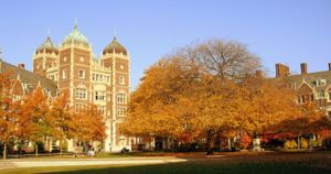 University of Pennsylvania

Education in Philadelphia is provided by many private and public institutions. The School District of Philadelphia runs the city's public schools. The Philadelphia School District is the seventh largest school district in the United States with 217,405 students in 273 schools.
Philadelphia is one of the largest college towns in the United States with over 120,000 college and university students enrolled within the city and nearly 300,000 in the metropolitan area. Temple University's main campus is two miles north of City Hall and has campuses in Philadelphia's central business district and the suburb of Ambler. A western section of the city, known as University City, is home to two of the city's universities. The University of Pennsylvania, a member of the Ivy League. Adjacent to the University of Pennsylvania campus resides Drexel University. West Philadelphia is also home to Saint Joseph's University.
Infrastructure

Philadelphia is served by the Southeastern Pennsylvania Transportation Authority (SEPTA), which operates buses, trains, rapid transit, trolleys, and trackless trolleys throughout Philadelphia and the four Pennsylvania suburban counties of Bucks, Chester, Delaware, and Montgomery. The city's subway system, first opened in 1907, is the third oldest in America.
One of the seven SEPTA Regional Rail lines (the R1) offers direct service to the Philadelphia International Airport.
Philadelphia's 30th Street Station is a major railroad station on Amtrak's Northeast Corridor, which offers access to Amtrak, SEPTA, and New Jersey Transit lines.
PATCO provides rapid transit service to Camden, Collingswood, Westmont, Haddonfield, Woodcrest (Cherry Hill), Ashland (Voorhees), and Lindenwold, New Jersey, from stations on Locust Street between 16th and 15th, 13th and 12th, and 10th and 9th Streets, and on Market Street at 8th Street.
Airports
Two airports serve Philadelphia: Philadelphia International Airport (PHL), straddling the southern boundary of the city, and Northeast Philadelphia Airport (PNE), a general aviation reliever airport in Northeast Philadelphia. Philadelphia International Airport provides scheduled domestic and international air service, while Northeast Philadelphia Airport serves general and corporate aviation.
Roads
Interstate 95 (I-95), which runs through the city along the Delaware River, is the main north-south artery.
The city is also served by the Schuylkill Expressway, a portion of Interstate 76 that runs along the Schuylkill River. It meets the Pennsylvania Turnpike at King of Prussia, Pennsylvania, providing access to Harrisburg, Pennsylvania and points west. The Turnpike's Northeastern Extension provides access to points north, including Allentown, Pennsylvania, the Lehigh Valley, and The Poconos.
Interstate 676, the Vine Street Expressway, was completed in 1991 after years of planning. A link between I-95 and I-76, it runs below street level through Centre City, connecting to the Ben Franklin Bridge at its eastern end.
Roosevelt Boulevard and the Roosevelt Expressway ( U.S. Route 1) connect Northeast Philadelphia with Centre City. The boulevard was built for the Lincoln Highway as part of the City Beautiful movement. In recent years, it has become a traffic bottleneck, and includes the second and third deadliest intersections in the U.S. within a single mile, according to a study by State Farm Insurance.
The Woodhaven Road ( PA Route 63), built in 1966, serves the neighborhoods of Northeast Philadelphia, running between Interstate 95 and the Roosevelt Boulevard ( U.S. Route 1). Plans to extend it westward into the suburbs were quashed by community opposition when the highway was first built. Severe traffic congestion over the past four decades on adjoining Byberry Road has led to renewed plans for extension and expansion. Several suggested plans would expand different roads using different methods to connect to the highway. A final decision has not yet been reached, and undoubtedly the construction phase will continue for several years after the planning stage is completed.
The Delaware River Port Authority operates four bridges in the Philadelphia area across the Delaware River to New Jersey: the Walt Whitman Bridge (I-76), the Benjamin Franklin Bridge (I-676 and US 30), the Betsy Ross Bridge ( Route 90), and the Commodore Barry Bridge ( US 322). The Tacony-Palmyra Bridge connects PA Route 73 with New Jersey's Route 73, and is maintained by the Burlington County Bridge Commission.
Other planned freeways have been cancelled, such as an Interstate 695 running southwest from downtown, two freeways connecting Interstate 95 to Interstate 76 that would have replaced Girard Avenue and South Street and a freeway upgrade of Roosevelt Boulevard.
Not all highways important to Philadelphia cross into the city limits. The Pennsylvania Turnpike bypasses the city a third of a mile to the north, and the New Jersey Turnpike, the main highway connection to New York City and points beyond, bypasses the city to the east and south. Interstate 476, locally known as "The Blue Route" (from its designation as an alternative on original PennDoT planning proposals in the 1960's) opened in 1991 after years of delays and contention. It connects I-95 to the turnpike and Northeast Extension at the Mid County Interchange in Plymouth Meeting, providing a bypass to the west of the city.
Philadelphia is also a major hub for Greyhound Bus Lines, which operates 24-hour service to points east of the Mississippi River. The city is the third busiest terminal in the country for Greyhound, after New York and Atlantic City, New Jersey.
Rail

Since the early days of rail transport in the United States, Philadelphia has served as hub for several major rail companies, especially the Pennsylvania Railroad and the Reading Railroad. The Pennsylvania Railroad first operated Broad Street Station, then 30th Street Station and Suburban Station, and the Reading Railroad operated out of Reading Terminal, now part of the Pennsylvania Convention Centre. The two companies also operated competing commuter rail systems in the area, known collectively as the Regional Rail system. The two systems today, for the most part still intact but now connected, operate as a single system under the control of Southeastern Pennsylvania Transportation Authority, the regional transit authority.
Philadelphia is also notable as one of the few North American cities to maintain streetcar lines. In addition to "subway-surface" trolleys (so called because during the years when the city was served by over 2000 trolleys and more than 65 lines, these were the "surface" cars that ran also in the streetcar subway), the city recently reintroduced trolley service to the Girard Avenue Line, Route 15, considered by some a "heritage" line; although the use of rebuilt 1947 PCC streetcars was primarily for budgetary reasons, rather than as an historic tribute.
Today Philadelphia is a hub of the semi-nationalized Amtrak system, with 30th Street Station being the primary local stop on the Washington-Boston Northeast Corridor and the Keystone Corridor to Harrisburg and Pittsburgh, Pennsylvania. 30th Street also serves as a major station for services via the Pennsylvania Railroad's former Pennsylvania Main Line to Chicago. 30th Street is Amtrak's third-busiest station in terms of passengers as of fiscal year 2003. It is also a terminus of New Jersey Transit's Atlantic City Line.
Telecommunications
Southeastern Pennsylvania has been served the 215 area code since 1947 when the North American Numbering Plan went into effect. The area covered by the code was severely truncated when area code 610 was split from 215. Today only the city and its northern suburbs are covered by 215. Overlay code 267 was added to the 215 service area in 1997.
Sister cities
Philadelphia has fifteen sister cities, as designated by Sister Cities International, Inc. (SCI):
|
Philadelphia has dedicated landmarks to its sister cities. Dedicated in June 1976, the Sister Cities Plaza, a one-half-acre site located at 18th and Benjamin Franklin Parkway, honours Philadelphia's relationships with Tel-Aviv, Israel and Florence, Italy, which were its first Sister Cities. Another landmark, the Torun Triangle, honoring the Sister City relationship with Toruń, Poland, was constructed in 1976, west of the United Fund building at 18th Street and the Benjamin Franklin Parkway. The Triangle contains the Copernicus monument. The Chinatown Gate, erected in 1984 and crafted by artisans of Tianjin, China, stands astride the intersection of 10th and Arch Streets as an elaborate and colorful symbol of the Sister City relationship.