Amarillo, Texas
2007 Schools Wikipedia Selection. Related subjects: North American Geography
| Amarillo, Texas | |||||
|
|||||
| Nickname: "The Yellow Rose of Texas, Helium Capital of the World, Rotor City USA" | |||||
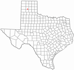
| Location within the state of Texas | |||||
| Coordinates: | |||||
|---|---|---|---|---|---|
| Country | United States | ||||
| State | Texas | ||||
| County | Potter (and Randall) | ||||
| Mayor | Debra McCartt | ||||
| Area | |||||
| - City | 233.9 km² (90.3 sq mi) | ||||
| - Land | 232.7 km² (89.8 sq mi) | ||||
| - Water | 1.2 km² (0.5 sq mi) | ||||
| Elevation | 1,099 m (3,605 ft) | ||||
| Population | |||||
| - City (2005) | 183,021 | ||||
| - Density | 782.5/km² (2,026.8/sq mi) | ||||
| - Metro | 236,113 | ||||
| Time zone | CST ( UTC-6) | ||||
| - Summer ( DST) | CDT ( UTC-5) | ||||
| Website: http://www.ci.amarillo.tx.us/ | |||||
Amarillo is the 14th-largest city in the U.S. state of Texas and the county seat of Potter County. A portion of the city extends into Randall County. As of the 2000 U.S. Census, the city had a total population of 173,627 (though a July 1, 2005 estimate placed the city's population at 183,021). The Amarillo metropolitan area, however, has an estimated population of 236,113 in four counties.
The city was once self-proclaimed as the "Helium Capital of the World" for having one of the country's most productive helium fields. The city is also known as "The Yellow Rose of Texas" and most recently "Rotor City, USA" for its V-22 Osprey hybrid aircraft assembly plant. Amarillo operates one of the largest meat packing areas in the United States. Pantex, the only nuclear weapons assembly and disassembly facility in the country, is also a major employer. The attractions, Cadillac Ranch and Big Texan Steak Ranch, were located on old U.S. Route 66, which passes through the city.
History
In April 1887, J. T. Berry established a site for a town after he chose a well-watered section along the way of the Fort Worth and Denver City Railroad, which had begun building across the Texas Panhandle. Berry and Colorado City, Texas merchants wanted to make their new town site the region's main trading centre. On August 30, 1887, Berry's town site won the county seat election and was established in Potter County. Availability of the railroad and freight service after the county seat election made the town a fast growing cattle marketing centre.
The settlement originally was called Oneida, it would later change its name to Amarillo. Amarillo's name probably derives from the nearby Amarillo Lake and Amarillo Creek, named in turn for the yellow soil along their banks and shores (Amarillo is the Spanish word for the colour yellow) or the yellow wildflowers that were plentiful during the spring and summer. Despite having a Spanish origin name, the City of Amarillo is pronounced in English as "Am-ah-RILL-ow" rather than "Ah-mah-REE-yoh". Early residents pronounced it according to the Spanish pronunciation, but within a year, the English pronunciation prevailed. Charles F. Rudolph, editor of the Tascosa Pioneer, predicted the pronunciation change after blaming Fort Worth and Denver City Railroad employees for ignoring the word's Spanish pronunciation.
On June 19, 1888, Henry B. Sanborn, who is given credit as the "Father of Amarillo," and his business partner Joseph F. Glidden began buying land to the east to move Amarillo after arguing that Berry's site was on low ground and would flood during rainstorms. Sanborn also offered to trade lots in the new location to businesses in the original city’s site and help the expense of moving buildings. His incentives gradually won over people, who moved their businesses to Polk Street in the new commercial district. It rained heavily and almost flooded Berry’s part of the town in 1889, prompting more people to move to Sanborn's location. This eventually led to another county seat election making Sanborn's town the new county seat in 1893.
By the late 1890s, Amarillo had emerged as one of the world's busiest cattle shipping points, and its population grew significantly. The city became an elevator, milling, and feed-manufacturing centre after an increasing production of wheat and small grains during the early 1900s. Discovery of gas in 1918 and oil three years later brought oil and gas companies to the Amarillo area. The United States government bought the Cliffside Gas Field with high helium content in 1927 and the Federal Bureau of Mines began operating the Amarillo Helium Plant two years later. The plant would be the sole producer of commercial helium in the world for a number of years. The U.S. National Helium Reserve is stored in the Bush Dome Reservoir at the Cliffside facility.
Following the lead of the Fort Worth and Denver City Railroad, the Atchison, Topeka and Santa Fe Railway and Chicago, Rock Island and Pacific Railroad established services to and from Amarillo. Each of these three carriers maintained substantial freight and passenger depots and repair facilities in the city through most of the 20th century and were major employers within the community.
During the 1930s, the city was hit by the Dust Bowl and entered into an economic depression. The U.S. Routes 60, 87, 287, and 66 merged at Amarillo, making it a major tourist stop with numerous motels, restaurants, and curio shops. World War II led the establishment of Amarillo Army Air Field in east Amarillo and the nearby Pantex Army Ordnance Plant, which produced bombs and ammunition. After the end of the war, both of the facilities were closed. The Pantex Plant was reopened in 1950 and produced nuclear weapons throughout the Cold War. The following year, the army air base was reactivated as Amarillo Air Force Base and expanded to accommodate a Strategic Air Command B-52 Stratofortress wing. The arrival of servicemen and their families ended the city's depression. Between 1950 and 1960, Amarillo's population grew from 74,443 to 137,969. However, the closure of the Amarillo Air Force Base on December 31, 1968, contributed to a decrease in population to 127,010 by 1970. In the 1970s, ASARCO, Iowa Beef Processors, Owens-Corning and Weyerhaeuser built plants at Amarillo. The following decade, Amarillo's city limits encompassed 60 square miles in Potter and Randall counties. The intrastate interstate highway I-27 connecting Lubbock to Amarillo was built mostly during the 1980s.
Geography and climate
Amarillo is located near the middle of the Texas Panhandle and is part of the Llano Estacado or Staked Plains region which has a surface that is relatively flat and has little drainage in the soil. Due to the lack of developed drainage, much of the rainfall either evaporates, infiltrates into the ground, or accumulates in playa lakes. According to the United States Census Bureau, the city has a total area of 90.3 mi² (233.9 km²). 89.9 mi² (232.7 km²) of it is land and 0.4 mi² (1.2 km²) of it (0.50%) is water. The Amarillo metropolitan area is the 180th-largest in the United States with a population of 236,113 in four counties: Armstrong, Carson, Potter, and Randall.
About 40 mi (64 km) northeast of Amarillo is the Canadian River, which divides the southern part of the High Plains to form the Llano Estacado. The river is dammed to form Lake Meredith, a major source of drinking water in the Texas Panhandle region. The city is situated near the Panhandle Field, in a productive gas and oil area, covering 200,000 surface acres in Hartley, Potter, Moore, Hutchinson, Carson, Gray, Wheeler, and Collingsworth counties. The Potter County portion had the nation's largest natural gas reserve. Approximately 25 mi (40 km) south of Amarillo is the canyon system, Palo Duro Canyon.
Cityscape
Most of Amarillo’s population growth and commercial development are occurring in the southern and northwestern parts of the city. Similar to many towns in the Texas Panhandle, the city’s downtown has suffered economic deterioration throughout the years. In order to try to help revitalize it, the organization Centre City of Amarillo was formed to establish partnerships with groups who have a huge presence in the city to support the downtown. Since its conception in the 1990s, Centre City created archways over two streets, sponsors public art projects such as murals, and started block parties in the downtown area.
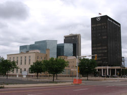
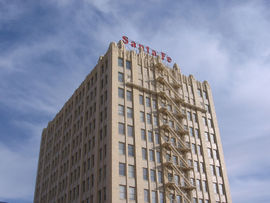
The 31-story Chase Tower, the tallest building between Dallas and Denver, was opened in Amarillo's downtown in 1971. It is an office building and had two prior names: SPS Tower and Bank One Centre. Completed in the same year as the Chase Tower, the Amarillo National Bank Plaza One building houses the headquarters of Amarillo National Bank, the city's largest financial institution. The Santa Fe Building, completed in 1930, was the regional offices of the Atchison, Topeka and Santa Fe Railway company but was vacant for several years until Potter County bought the building for US$426,000 in 1995 to gain new office spaces.
Amarillo's historic homes and buildings listed on the National Register of Historic Places reflect the economic growth from around 1900 to the start of World War II. Polk Street contains many of the city's historic downtown buildings and homes. The large historic homes on this street were built close to downtown, and homes were located on the west side of the street as a symbol of status because they would be greeted with the sunrise every morning. A local newspaper article in 1914 promoted the planting of trees as a sanitary asset due to the author cited studies by the New York County Medical Society and the New York City Park Commission which claims areas with trees have less bacteria and fewer dust particles. The trees that lasted the Texas Panhandle environment line the streets in Amarillo's older neighborhoods.
The City of Amarillo's Parks and Recreation Department operates over 50 municipal parks including a skatepark, west of the city. Amarillo's largest parks are Medical Park, Thompson Memorial Park, and Memorial Park, near Amarillo College's Washington Street Campus. From 1978 to 2002, the Junior League of Amarillo and the City of Amarillo's Parks and Recreation Department co-sponsored Funfest, a family entertainment festival, benefiting the city parks and the league's Community Chest Trust Fund. Funfest was held in Thompson Memorial Park during Memorial Day weekend. Completed in 2000, Dr. Martin Luther King Jr. Memorial Park adjoins with a shallow playa lake which located south of it was the original town site of Amarillo.
Climate
Amarillo and along with the Texas Panhandle's climate is classified as subhumid to semiarid. It is characterized by a rush of cold air from the north or northwest into a warmer area and occasionally, by blizzards during the winter season and a hot summer. The normal annual rainfall for Amarillo is approximately 20 inches (508 mm). Most of the region's precipitation occurs in the late spring and summer months, and the least occurs from November through March. The January's average high in the city is 49 °F (9 °C) and average low is 22 °F (-6 °C); July's average high is 91 °F (33 °C) and average low is 65 °F (18 °C). The highest temperature ever recorded in Amarillo was 108 °F (42 °C); the lowest was -16 °F (-27 °C). Amarillo is in an area of the United States which tornadoes are most frequent called the " Tornado Alley."
| Jan | Feb | Mar | Apr | May | Jun | Jul | Aug | Sep | Oct | Nov | Dec | Year | |
|---|---|---|---|---|---|---|---|---|---|---|---|---|---|
| Average high temperature °F ( °C) | 49 (9.4) |
53 (11.7) |
61 (16.1) |
71 (21.7) |
79 (26.1) |
88 (31.1) |
91 (32.8) |
89 (31.7) |
82 (27.8) |
72 (22.2) |
59 (15.0) |
51 (10.5) |
71 (21.6) |
| Average low temperature °F (°C) | 22 (–5.5) |
26 (–3.3) |
32 (0.0) |
42 (5.5) |
52 (11.1) |
61 (16.1) |
66 (18.9) |
64 (17.8) |
57 (13.9) |
45 (7.2) |
32 (0.0) |
24 (–4.4) |
44 (6.7) |
| Average precipitation inches ( mm) | 0.5 (12.7) |
0.6 (15.2) |
0.9 (22.9) |
1.1 (27.9) |
2.8 (71.1) |
3.5 (88.9) |
2.8 (71.1) |
3.0 (76.2) |
1.9 (48.3) |
1.3 (33.0) |
0.6 (15.2) |
0.5 (12.7) |
19.6 (497.8) |
Demographics
| Year | Pop. |
|---|---|
| 1940 | 51,686 |
| 1950 | 74,246 |
| 1960 | 137,969 |
| 1970 | 127,010 |
| 1980 | 149,230 |
| 1990 | 157,615 |
| 2000 | 173,627 |
| 2005 (est.) | 183,021 |
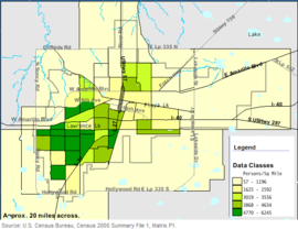
As of the census GR2 of 2000, there were 173,627 people, 67,699 households, and 45,764 families residing in the city. The population density was 1,932.1/mi² (746.0/km²). There were 72,408 housing units at an average density of 805.8/mi² (311.1/km²). Given Amarillo's growth rate, however, the numbers have increased, and the city's population is approximately 183,021 according to a July 1, 2005 estimate.
The racial makeup of the city was 77.50% White, 5.97% African American, 0.78% Native American, 2.05% Asian, 0.04% Pacific Islander, 11.32% from other races, and 2.34% from two or more races. Hispanic or Latino of any race were 21.86% of the population which had a significant increase of 63.35% compare to the 1990 U.S. Census report.
There were 67,699 households, of which 33.9% had children under the age of 18 living with them, 50.6% were married couples living together, 12.8% had a female householder with no husband present, and 32.4% were classified as non-families by the United States Census Bureau. Of 67,699 households, 2,981 were unmarried partner households: 2,713 heterosexual, 82 same-sex male, and 186 same-sex female. 27.7% of all households were made up of individuals and 9.9% have someone living alone who was 65 years of age or older. The average household size was 2.53 and the average family size was 3.10.
In the city the population was spread out with 27.9% under the age of 18, 10.2% from 18 to 24, 28.8% from 25 to 44, 20.5% from 45 to 64, and 12.6% who were 65 years of age or older. The median age was 34 years. For every 100 females there are 92.4 males. For every 100 females age 18 and over, there were 88.5 males.
The median income for a household in the city was $34,940, and the median income for a family was $42,536. Males had a median income of $31,321 versus $22,562 for females. The per capita income for the city was $18,621. About 11.1% of families and 14.5% of the population were below the poverty line, including 19.6% of those under age 18 and 9.3% of those age 65 or over. Approximately 37.5% of African American households in 2000 had an income below $15,000, compared to 17.59% of White households and 22.08% of Hispanic households. In addition, about over 34.6% of the total African American population lived in poverty, compared to 22.8% of the Hispanic population and 10% of the White population.
Law and government
In 1913, Amarillo became the first Texas city and the fifth in United States to use the council-manager form of municipal government, with all governmental powers resting in a legislative body called a commission. Amarillo's commission composed of five elected commissioners, one of whom is the mayor of the city. The mayor and each commissioner serves a two-year term. The role of the commission is to pass ordinances and resolutions, adopt regulations, and appoint city officials, including the city manager. While the mayor serves as a presiding officer of the commission, the city manager is the administrative head of the municipal government, and is responsible for the administration of all departments. The city commission holds its regular meetings on Tuesday of each week.
| Mayor | Debra McCartt |
| Commissioner Place 1 | Madison Scott |
| Commissioner Place 2 | Paul Harpole |
| Commissioner Place 3 | Robert Keys |
| Commissioner Place 4 | Jim Simms |
| City manager | Alan M. Taylor |
| Assistant city manager | Jarrett Atkinson |
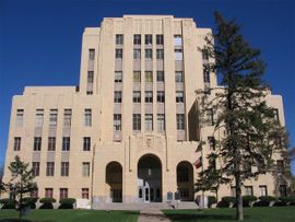
Amarillo is in the U.S. House 13th Congressional district, and is represented by Representative Mac Thornberry. In the Texas Legislature, the city is in the 31st District in the Texas Senate and in the 87th district in the Texas House of Representatives. As the seat of Potter County, the city is the location of the county's trial, civil, and criminal courts. The Randall County Amarillo Annex building is located within the city limits and houses its Sheriff's Office and Justice of the Peace Court, Precinct 4.
Economy
Amarillo is considered the regional economical centre for the Texas Panhandle as well as Eastern New Mexico and the Oklahoma Panhandle. The meat packing industry is a major employer in Amarillo; about one-quarter of the United States' beef supply is processed in the area. The city is also the location of headquarters for the Texas Cattle Feeders Association. Petroleum extraction is also a major industry. The helium industry has decreased in significance since the federal government privatized local operations in the late 1990s. Bell Helicopter Textron opened a helicopter assembly plant near the city's international airport in 1999. According to the U.S. Bureau of Labor Statistics, the industry with the largest contribution to personal income in the city was the services industry with 23.52% in 2000. The government industry contributed 16.37% while retail trade category contributed 10.16%.
The city's largest employer in 2005 is Tyson Foods with 3,700 employees. The Amarillo Independent School District is next with 3,659 employees followed by BWXT Pantex, Baptist St. Anthony’s Health Care System, City of Amarillo, Northwest Texas Healthcare System, Amarillo College, and United Supermarkets. Other major employers include Bell Helicopter Textron, Owens-Corning, and ASARCO.
Approximately 14 million acres (5.7 million hectares) of agricultural land surrounds the city with corn, wheat and cotton as the primary crops. Other crops in the area include sorghum, silage, hay and soybeans. The Texas Panhandle, particularly in Hereford, Texas, serves as a fast growing milk producing area as several multi-million dollar state of the art dairies were built in early 2000s.
The Amarillo Economic Development Corporation (AEDC) is funded by a city sales tax, and it provides aggressive incentive packages to existing and prospective employers. In the mid-to-late 1990s, the AEDC gained notoriety by sending mock checks to businesses across the country, placing full-page advertisements in The Wall Street Journal, and paying an annual $1 million subsidy to American Airlines to retain jet service. The AEDC is largely responsible for bringing Bell Helicopter Textron's development of the V-22 Osprey hybrid aircraft and the future site of Marine One assembly in Amarillo.
Education
According to the 2000 United States Census, 20.5% of all adults over the age of 25 in Amarillo have obtained a bachelor's degree, as compared to a national average of 24.4% of adults over 25, and 79.3% of Amarillo residents over the age of 25 have earned a high school diploma, as compared to the national average of 80.4%.
The higher education institutions in the city are Amarillo College, a two-year community college with over 10,000 students; Wayland Baptist University, a private university based in Plainview, has a branch campus in Amarillo; and Texas Tech University at Amarillo, a branch campus of Texas Tech University that offers selected master's degree programs. West Texas A&M University, in nearby Canyon, is the regional university in the Amarillo area and the Texas Panhandle.
The public primary and secondary education are mostly handled by the Amarillo Independent School District (AISD) and Canyon Independent School District. (CISD) The AISD has approximately 29,000 students in 2004 while CISD has over 8,000 students in 2005. The AISD operates 4 high schools, 9 middle schools, 36 elementary schools, a specialty high school, and an alternative school. While, the CISD has 1 high school, 2 junior high/intermediate schools, and 4 elementary schools in Amarillo. Other school districts in the city are River Road, Highland Park, and Bushland Independent School Districts. Nonreligious and Christian denomination private schools in Amarillo include St. Andrew's Episcopal School, Holy Cross Catholic Academy, Amarillo Montessori Academy, San Jacinto Christian Academy, Bible Heritage Christian School, and Arbor Christian Academy.
Culture
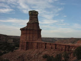
Amarillo has a number of natural attractions near the city. The Palo Duro Canyon State Park is United States' second largest canyon system, after the Grand Canyon and is located south of Amarillo. Palo Duro has a distinct hoodoo that resembles a lighthouse. Another natural landmark near the city, the Alibates Flint Quarries National Monument is located 30 miles (48.2 km) north of Amarillo. It is once known as the site for prehistoric inhabitants to obtain flint in order to make tools and weapons. About 100 miles (161 km) southeast of Amarillo in Briscoe County is Caprock Canyons State Park and Trailway, the state park is the home of the official Texas State Bison Herd, who were captured and taken care of by cattle rancher Charles Goodnight.
Local millionare Stanley Marsh 3 has funded many public art projects in the city including the Cadillac Ranch, located west of Amarillo on I-40, a monument of painted Cadillac automobiles that were dug into the ground head first. Marsh also participates an on-going art project called the Dynamite Museum, which consist of thousands of mock traffic signs. These signs, bearing messages such as "Road does not end" or displaying a random picture, are scattered throughout the city of Amarillo.
The city has events and attractions honoring the cowboy and Texas culture. During the third week of September, the Tri-State Fair & Rodeo brings participants mostly from Oklahoma, New Mexico and Texas to Amarillo since 1921. On the Tri-State Exposition grounds, the Amarillo National Centre is a special events centre for events ranging from national equestrian competitions to motor sports and rodeos. The World Championship Ranch Rodeo sponsored by the Working Ranch Cowboys Association is held every November in the Amarillo Civic Centre. Amarillo hosts the annual World Championship Chuckwagon Roundup the first weekend in June. Teams in competition prepare a feast of breaded beef cutlets, mashed potatoes, baked beans, and sourdough biscuits and attempt to duplicate the food served on western cattle trails of the 1860s and 1870s. The Amarillo Livestock Auction holds a free to the public cattle auction on Tuesdays. Now located on I-40, The Big Texan Steak Ranch, was made famous by offering visitors a free 72 ounce (2 kg) beef steak if they eat it and its accompanying dinner in under an hour.
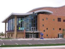
Globe-News Centre for the Performing Arts, opened in 2006, houses the Amarillo Opera, Amarillo Symphony, and Lone Star Ballet concerts. The facility, located just across the Amarillo Civic Center, features a 1,300-seat auditorium. The Globe-News Centre was built in hope by the city officials and others that it will spur a revitalization of the downtown area. The nonprofit community theatre group, Amarillo Little Theatre, has its season run from September to May. The theatre group's two facilities are located west of Amarillo's downtown. In the Palo Duro Canyon’s amphitheatre, an outdoor musical called Texas plays nightly during the summer. The musical depicts a story about the history of Texas Panhandle settlers throughout the years. In 2002, the producers changed its name to Texas Legacies after retiring the previous script that was used for 37-years for a more historically accurate one but they decided to revert back to the original script due to declining attendance in 2006.
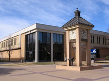
The Amarillo Public Library is affiliated with the Harrington Library Consortium. The consortium consist of public, college, and school libraries located in the Texas Panhandle that share resources and cooperate with one another. Other members include the Amarillo's public schools, Amarillo College, Canyon Area Library, Lovett Memorial Library in Pampa, Texas, and Hutchinson County Library in Borger, Texas. The Amarillo Public Library's main branch is located in downtown and operates 4 neighbourhood branches.
Amarillo residents are known as Amarilloans. Notable Amarilloans include the Dory Funk wrestling family, astronaut Rick Husband, actress Carolyn Jones, actress and dancer Cyd Charisse, politican John Marvin Jones, businessman T. Boone Pickens, Jr., and famed gambler Thomas " Amarillo Slim" Preston.
Museums and art collections
The American Quarter Horse Association (AQHA) is an international organization dedicated to the preservation, improvement and record-keeping of the American Quarter Horse breed. The organization is headquartered in Amarillo and has a museum. In addition, the AQHA and Centre City of Amarillo co-sponsors the project, "Hoof Prints of the American Quarter Horse" which consist of horse statues located in front of several Amarillo businesses. An area business would purchase a horse statue and a local artist paints on it.
Two of the Amarillo area's higher education institutions have at least one museum in their campuses. The Amarillo Art Centre, opened in 1972, is a building complex with an art museum and concert hall located on the Washington Street Campus of Amarillo College. In addition, Amarillo College's Washington Street Campus is the home of the largest natural history museum of any two-year college in the United States. Located on the campus of West Texas A&M University, the Panhandle-Plains Historical Museum claims to be the largest historical museum in Texas.
Don Harrington Discovery Centre, located in the city's hospital district, is an interactive science center and space theatre with over 60 hands-on exhibits. Outside of the building contains a steel structure called the Helium Monument which has time capsules and designates Amarillo the "Helium Capital of the World." Near the proximity of the Discovery Centre, the Amarillo Botanical Gardens has gardens, indoor exhibits, and a library for visitation throughout the year. The Texas Pharmacy Museum claims to be the only Texas museum specialized in the research, collection, preservation, and exhibition of the history of pharmacy, is also located in the city's hospital district.
Other notable museums in the area are the Kwahadi Kiva Indian Museum and the English Field Air & Space Museum. The Kwahadi Kiva Indian Museum features a collection of Native American artifacts and provides dance performances. The English Field Air & Space Museum is operated by the Texas Aviation Historical Society and features aircraft and space exhibits. The museum's facility used to be city's main airport terminal.
Sports
The af2 indoor American football team Amarillo Dusters and the CHL hockey team Amarillo Gorillas both play in the Amarillo Civic Centre. Amarillo's minor league baseball team, Amarillo Dillas of the United League Baseball, plays its home games in the Potter County Memorial Stadium. Before the founding of the Dillas, the city was the home of the AA Amarillo Gold Sox. Amarillo had a minor league in-door soccer team called the Amarillo Challengers that competed in the SISL and later the USISL.
West Texas A&M University features a full slate of NCAA Division II teams; however, Amarillo College is one of the few community colleges in Texas without an athletic program. From 1968 to 1996, Amarillo hosted the annual National Women's Invitational Tournament, a postseason women's college basketball tournament. During high school American football season, the Amarillo Independent School District schools' home games are in Dick Bivins Stadium which had a $5.7 million renovation in 2005. Randall High School (part of the adjacent Canyon Independent School District) plays its home games in Kimbrough Memorial Stadium in Canyon. River Road and Highland Park High Schools, also play football, as well as other sports.
Infrastructure
Transportation
Rick Husband Amarillo International Airport is located on the east side of Amarillo, north of Interstate 40. A portion of the former Amarillo Air Force Base was converted to civilian use and became part of the airport. The airport was named after Amarillo native Rick Husband, a NASA space shuttle astronaut and the commander of STS-107 (Columbia) who died in 2003 while returning from a mission in space. The airport is served by several major air carriers with non-stop service to Dallas, Houston, Albuquerque, Clovis, Denver, Phoenix, and Las Vegas.
Local transit services in the city have been available since 1925 and have been provided through the City of Amarillo's Amarillo City Transit (ACT) department since 1966; prior to that time the system was privately owned. ACT operates bus services that include fixed route transit and demand response paratransit which are designed for people with disabilities. The ACT transports approximately 350,000 passengers per year on the fixed route and 30,000 paratransit passengers, but it is a declining ridership. ACT has no plans to scale back any of their transit routes or services.
Amarillo has no passenger rail service but remains an important part of the rail freight system. The BNSF Railway complex in Amarillo continues to serve a heavy daily traffic load, approximately 100-110 trains per day. The Union Pacific Railroad also sends substantial shipments to or through Amarillo. In addition to intermodal and general goods, a big portion of rail shipments involve grains and coal.
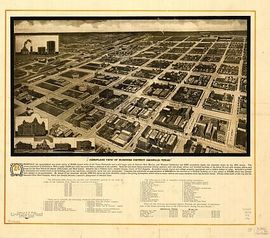
The streets in Amarillo's downtown area conform to a grid pattern. The city's original street layout was set up by William H. Bush, beginning at the west end of the town moving to the east. Bush named the north to south streets for past United States presidents, in chronological order except for John Quincy Adams because the surname was taken with the second president, John Adams. (The last president so honored was Grover Cleveland; though the city has expanded eastward the pattern was not continued.)
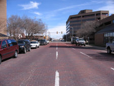
In 1910, the Amarillo voters approved to pay for street paving and the materials used to pave the streets were bricks. As of 2003, the city still has 16.2 mi (26.1 km) of brick streets in some parts of the downtown area. The city spent $200,000 in 2002 to restore one block of brick street on Ninth Avenue between Polk and Tyler streets.
Less than one mile of intrastate interstate highway I-27 is located in Potter County. The highway terminates at the city's main west-east highway I-40 near the Potter-Randall County line. The roadway continues northward into downtown Amarillo via U.S. 60, 87, and 287, a series of four one-way streets. North of downtown the highway becomes U.S. 87 and continues northward to Dumas, Texas.
Medical centers and hospitals
Amarillo is home to medical facilities including Baptist St. Anthony’s and Northwest Texas Hospitals, the Don & Sybil Harrington Cancer Centre, Bivins Memorial Nursing Home, Texas Tech University Health Sciences Centre, and Texas Tech School of Pharmacy. All are located in the Harrington Regional Medical Centre, the first specifically designated city hospital district in Texas.
Baptist St. Anthony's, known locally as BSA, had some of its services listed on the U.S. News & World Report's "Top 50 Hospitals" from 2002 to 2005. BSA was a result of a merger between the Texas Panhandle's first hospital, St Anthony's, with High Plains Baptist Hospital in 1996. The BSA Hospice & Life Enrichment Centre provides important services to the Amarillo area. The BSA facility, opened in 1985, was the first free-standing hospice west of the Mississippi River that was built and opened without debt.
The Thomas E. Creek Department of Veterans Affairs Medical Center is located east of Harrington Regional Medical Centre. The facility opened in 1940 and was renamed in 2005, honoring the 18-year old Amarillo Marine who was posthumously awarded the Medal of Honour. Construction began in 2006 for a new Texas State Veterans Home in northwest Amarillo. The United States government, through the Veterans Affairs Medical Centre, provided the funding to build the facility, while the Texas government will run it after construction is completed. The home is scheduled to open in 2007.
Utilities
Drinking water is provided by the City of Amarillo and its Utilities Division. Amarillo's water supply comes from Lake Meredith and the Ogallala Aquifer. The city's drinking water is a blend of both sources. Lake Meredith is located northeast of Amarillo contains at least 114 billion gallons (431 million m³) of water. The city's daily water production averages between 40-50 million gallons (151,000-189,000 m³).
Collection and disposal of city's trash or garbage are the responsibility of City of Amarillo's Solid Waste Collection and Solid Waste Disposal Departments. Amarillo's non-hazardous solid waste are collected and disposed it through burial in the city's landfill. The City of Amarillo also operates recycling collection centers located one near the downtown area and at 4 fire stations in the city. Other utilities are primarily provided by private organizations. Natural gas is distributed by Atmos Energy. Electric power service is distributed by Xcel Energy. Wired telephone service provider is primarily by AT&T. Cable television is provided by Suddenlink Communications.
