Grand Canyon
2007 Schools Wikipedia Selection. Related subjects: North American Geography
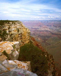
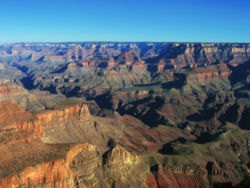
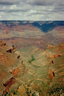
The Grand Canyon is a very colorful, steep-sided gorge, carved by the Colorado River, in the U.S. state of Arizona. It is largely contained within the Grand Canyon National Park — one of the first national parks in the United States. President Theodore Roosevelt was a major proponent of the Grand Canyon area, visiting on numerous occasions to hunt mountain lions and enjoy the scenery.
The canyon, created by the Colorado River cutting a channel over millions of years, is about 277 miles (446 km) long, ranges in width from 0.25 to 15 miles (0.4 to 24 kilometers) and attains a depth of more than a mile (1,600 m). Nearly two billion years of the Earth's history has been exposed as the Colorado River and its tributaries cut through layer after layer of sediment as the Colorado Plateaus have uplifted.
The first recorded sighting of the Grand Canyon by a European was in 1540, García López de Cárdenas from Spain. The first scientific expedition to the canyon was led by U.S. Major John Wesley Powell in the late 1860s. Powell referred to the sedimentary rock units exposed in the canyon as "leaves in a great story book." Long before that, the area was inhabited by Native Americans who built settlements within the canyon walls.
Geography
The Grand Canyon is a very deep - in places over a mile (1600 m) deep - 277 mile (446 km) long cut in the Colorado Plateau that exposes uplifted Proterozoic and Paleozoic strata. The canyon appears on many versions of the Seven Natural Wonders of the World list, although none of these lists is by any means authoritative. The exposed strata are gradually revealed by the gentle incline beginning at Lee's Ferry and continuing to Hance Rapid. At the point where the river crosses the Grand Wash Fault (near Lake Mead) the Canyon ends.
Uplift associated with plate tectonics-caused mountain building events later moved these sediments thousands of feet upward and created the Colorado Plateau. The higher elevation has also resulted in greater precipitation in the Colorado River drainage area, but not enough to change the Grand Canyon area from being semi-arid. Landslides and other mass wasting events then caused headward erosion and stream capture - all of which tend to increase the depth and width of canyons in arid environments.
The uplift of the Colorado Plateau is uneven, resulting in the North Rim of the Grand Canyon being over a thousand feet (about 300 meters) higher than the South Rim. The fact that the Colorado River flows closer to the South Rim is also explained by this asymmetrical uplift. Almost all runoff from the plateau behind the North Rim (which also gets more rain and snow) flows toward the Grand Canyon, while much of the runoff on the plateau behind the South Rim flows away from the canyon (following the general tilt). The result is much greater erosion and thus faster widening of the canyon and its tributary canyons north of the Colorado River.
Temperatures on the North Rim are generally lower than the South Rim because of the greater elevation (8000 feet/2438 meters above sea level). Heavy snowfall is common during the winter months. Views from the North Rim tend to give a better impression of the expanse of the canyon than those from the South Rim.
Geology
The principal consensus among geologists is that the Colorado River basin (of which the Grand Canyon is a part) has developed in the past 40 million years and that the Grand Canyon itself is probably less than five to six million years old (with most of the downcutting occurring in the last two million years). The result of all this erosion is one of the most complete geologic columns on the planet.
The major geologic exposures in Grand Canyon range in age from the 2 billion year old Vishnu Schist at the bottom of the Inner Gorge to the 230 million year old Kaibab Limestone on the Rim. Many of the formations were deposited in warm shallow seas, near-shore environments (such as beaches), and swamps as the seashore repeatedly advanced and retreated over the edge of a proto-North America. Major exceptions include the Permian Coconino Sandstone which was laid down as sand dunes in a desert and several parts of the Supai Group.
The great depth of the Grand Canyon and especially the height of its strata (most of which formed below sea level) can be attributed to 5,000 to 10,000 feet (1500 to 3000 m) of uplift of the Colorado Plateaus, starting about 65 million years ago (during the Laramide Orogeny). This uplift has steepened the stream gradient of the Colorado River and its tributaries, which in turn has increased their speed and thus their ability to cut through rock (see the elevation summary of the Colorado River for present conditions).
Weather conditions during the ice ages also increased the amount of water in the Colorado River drainage system. The ancestral Colorado River responded by cutting its channel faster and deeper.
The base level and course of the Colorado River (or its ancestral equivalent) changed 5.3 million years ago when the Gulf of California opened and lowered the river's base level (its lowest point). This increased the rate of erosion and cut nearly all of the Grand Canyon's current depth by 1.2 million years ago. The terraced walls of the canyon were created by differential erosion.
About one million years ago, volcanic activity (mostly near the western canyon area) deposited ash and lava over the area, which at times completely obstructed the river. These volcanic rocks are the youngest in the canyon.
Human history
The Ancestral Puebloans (The Ancient Ones, or Anasazi)
- The Basketmakers
- The Pueblo Anasazi
- Ancient Puebloan Occupation of the Grand Canyon
- Nankoweap Canyon
- The Unkar Delta
- The Bright Angel Site
- Ancient Pueblo peoples leave the Canyon
- Beamer's Cabin
- The Beamers back windo
- Beamer's Cabin
Other cultures
- The Cohonina
- The Sinagua
- The Pai (The People)
- The Hualapai (The People of the Pine Trees)
- The Havasupai (The People of the blue-green water)
- The Paiutes (The Water People)
- The Dineh (The People)
European arrival and settlement
The Spanish Explorers
In September 1540, under orders from the conquistador Francisco Vasquez de Coronado to search for the fabled Seven Cities of Cibola, Captain Garcia Lopez de Cardenas, along with Hopi guides and a small group of Spanish soldiers, traveled to the South Rim of the Grand Canyon between Desert View and Moran Point. Pablo de Melgrossa, Juan Galeras and a third soldier descended some one third of the way into the Canyon until they were forced to return because of lack of water. It is speculated that their Hopi guides must have been reluctant to lead them to the river, since they must have known routes to the canyon floor. Afterwards, no Europeans visited the canyon for over two hundred years.
- Fathers Francisco Atanasio Domínguez and Silvestre Vélez de Escalante were two Spanish Priests who, with a group of Spanish soldiers, explored southern Utah and traveled along the North Rim of the Canyon in Glen and Marble Canyons in search of a route from Santa Fe to California in 1776.
American Exploration
James Ohio Pattie, along with a group of American trappers and mountain men, was probably the next European to reach the Canyon in 1826, although there is little documentation to support this .
Jacob Hamblin (a Mormon missionary) was sent by Brigham Young in the 1850's to locate easy river crossing sites in the Canyon. Building good relations with local Native Americans and white settlers, he discovered Lee's Ferry in 1858 and Pierce Ferry (later operated by, and named for, Harrison Pierce) - the only two sites suitable for ferry operation.
In 1857, the U.S. War Department asked Lieutenant Joseph Ives to lead an expedition to assess the feasibility of an up-river navigation from the Gulf of California. Also in a stern wheeler steamboat "Explorer", after two months and 350 miles (560 km) of difficult navigation, his party reached Black Canyon some two months after George Johnson. The "Explorer" struck a rock and was abandoned. Ives led his party east into the Canyon — they were the first Europeans to travel the Diamond Creek drainage and traveled eastwards along the South Rim.
- The John Wesley Powell River Expeditions
- The Brown-Stanton River Expedition
- Other expeditions
Settlement on the rim
- Miners
- "Captain" John Hance
- William W. Bass
- Louis Boucher "The Hermit"
- Seth Tanner
- Charles Spencer
- D. W. "James" Mooney
- Lees Ferry
- John Doyle Lee
- Emma Lee (17th of John Lee's 19 wives)
- J. S. Emmett
- Charles Spencer
- Phantom Ranch
- David Rust
- Mary Colter
- Grand Canyon Village
- Ralph H. Cameron
- Federal protection
Many challenges face the federal government administrators who manage park resources. These include issues related to: the recent reintroduction into the wild of the highly endangered California Condor, air tour overflight noise levels, water rights disputes with various tribal reservations that border the park, and forest fire management. The Grand Canyon National Park superintendent is Mr. Joe Alston who was previously the superintendent of Glen Canyon National Recreation Area (Lake Powell. Glen Canyon lies to the North and East of Grand Canyon on the Arizona/Utah Border.
Recent history
In 1956 the Grand Canyon was the site of America's worst commercial aviation disaster at the time.
On the morning of June 30, 1956, a TWA Lockheed Super Constellation and a United Airlines Douglas DC-7 departed Los Angeles International Airport within three minutes of one another on eastbound transcontinental flights. Approximately 90 minutes later, the two propeller-driven airliners collided above the canyon while both were flying in unmonitored airspace.
The wreckage of both planes fell into the eastern portion of the canyon, on Temple and Chuar buttes, near the confluence of the Colorado and Little Colorado rivers. The disaster killed all 128 passengers and crew members aboard both planes.
This accident led to the institution of high-altitude flightways and positive control by en route ground controllers.
Activities
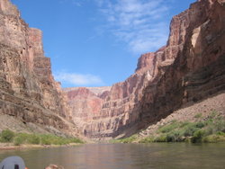
Aside from casual sightseeing from the South Rim (averaging 7000 feet/2134 m above sea level), whitewater rafting, hiking and running are especially popular. The floor of the valley is accessible by foot, muleback, or by boat or raft from upriver.
Hiking down to the river and back up to the rim in one day is discouraged by park officials because of the distance, effort required, and danger of heat exhaustion from the much higher temperatures at the bottom. Rescues are required annually of unsuccessful rim-to-river-to-rim travellers. Nevertheless, hundreds of fit and experienced hikers complete the trip every year. Hikers and runners who know their limits and have experience in a desert environment should not hesitate to undertake this fantastic journey. Weather is a primary consideration in this trip, so accurate forecasts are imperative. While the park service posts weather information at gates and visitor centers, this is a rough approximation only, and should not be relied upon for trip planning. For accurate weather in the Canyon, hikers should consult the National Weather Service's NOAA weather radio or the official NWS website .
The canyon is extremely popular with endurance athletes, who regularly run across it. A one-way trip (rim-to-rim) takes place in around five to seven hours, or a round-trip (the rim-to-rim-to-rim or "doublecross") in around 11-14 hours. Allyn Cureton of Williams, Arizona holds the record for a north to south crossing at 3:06, set in 1981. He also holds the record for the doublecross (South Kaibab version) at just under eight hours. Four runners (all experienced ultramarathon runners) have finished a "canyon quad" (four crossings in succession). Jim Nelson of Salt Lake City, Utah broke the speed record on November 6, 1999, with a time of 22:48. Previous to this, Wally Shiel established the quad record on October 4, 1987 with a time of 24:45. Other finishers are Dana Miller of Parowan, Utah (1993) and David Crockett of Saratoga Springs, Utah (2006). Crockett added side trips on rim trails and the Tonto Trail during his 39-hour journey to make his the first 100-mile uninterrupted continuous foot trip in the Canyon. In March 2006 Phil Lowry of Springville, UT finished a 56-mile noncorridor route in 18 hours, travelling from Grandview Point to Phantom Ranch via the Tonto Trail, then out and back to Clear Creek and back to the rim via the Bright Angel Trail.
The National Park Service provides wheelchairs for temporary day use by park visitors. No rental fee is charged.
|
The United States government made the Grand Canyon a national park in 1919 |
View from Lipan Point at dawn |
||
Grand Canyon Visitors
Grand Canyon National Park is one of the world’s premier natural attractions, attracting about five million visitors per year arriving from all 50 U.S. states and Puerto Rico and internationally. Overall, 83% were from the United States: California (12.2%), Arizona (8.9%), Texas (4.8%), Florida (3.4%) and New York (3.2%) represented the top domestic visitors. Seventeen percent of visitors were of foreign origins; the most prominently represented nations were the United Kingdom (3.8%), Canada (3.5%), Japan (2.1%), Germany (1.9%) and The Netherlands (1.2%).
Grand Canyon Fatalities
About 600 deaths have occurred in the Grand Canyon since the 1870s. Some of these deaths occurred as the result of overly zealous photographic endeavors, some were the result of airplane collisions within the canyon, and some visitors drowned in the Colorado River. Many hikers overestimate their fitness level, become dehydrated and confused, and must be rescued. The Park Service now posts a picture of an attractive and fit young man at several trailheads with the caption "Many of them look like him", in an attempt to discourage hikers from feats which are beyond their abilities.
According to Over the Edge: Death in the Grand Canyon, 50 fatalities have resulted from falls; 65 deaths were attributable to environmental causes, including heat stroke, cardiac arrest, dehydration, and hypothermia; 7 were caught in flash floods; 79 were drowned in the Colorado River; 242 perished in airplane and helicopter crashes (128 of them in the aforementioned 1956 disaster); 25 died in freak errors and accidents, including lightning strikes and rock falls; 47 committed suicide; and 23 were the victims of homicides.
