Image:Foot of Toroweap Looking East by William Holmes.jpg
From Wikipedia, the free encyclopedia
Foot_of_Toroweap_Looking_East_by_William_Holmes.jpg (559 × 328 pixel, file size: 41 KB, MIME type: image/jpeg)
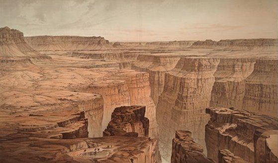
This panoramic view of the Grand Canyon by William H. Holmes was published in Clarence E. Dutton's 1882 atlas to accompany the monograph on the Tertiary History of the Grand Cañon District. This map was made as part of a government-sponsored survey of the canyon, which was the first attempt at stratigraphic mapping in the United States. Holmes was the leading scientific illustrator of topographic and geologic phenomena for the Great Western Surveys following the American Civil War. He later became the first director of the National Gallery of Art in Washington, D.C.
|
|
This file has been released into the public domain by the copyright holder, its copyright has expired, or it is ineligible for copyright. This applies worldwide. |
Note: This tag is deprecated! Please use instead:
|
From http://www.loc.gov/exhibits/treasures/trm164.html
File history
Legend: (cur) = this is the current file, (del) = delete this old version, (rev) = revert to this old version.
Click on date to download the file or see the image uploaded on that date.
- (del) (cur) 01:53, 11 May 2005 . . Maveric149 ( Talk | contribs) . . 559×328 (41,761 bytes) (This panoramic view of the Grand Canyon by William H. Holmes was published in Clarence E. Dutton's 1882 atlas to accompany the monograph on the ''Tertiary History of the Grand Cañon District''. This map was made as part of a government-sponso)
-
Edit this file using an external application
See the setup instructions for more information.
File links
- History of the Grand Canyon area
- Wikipedia:Featured article candidates/Featured log/May 2005
- Wikipedia:Featured article candidates/History of the Grand Canyon area
Category: Public domain images