Tropical Storm Henri (2003)
2007 Schools Wikipedia Selection. Related subjects: Storms
| Tropical storm ( SSHS) | ||
|---|---|---|
|
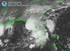
Tropical Storm Henri near peak intensity |
||
| Formed | September 3, 2003 | |
| Dissipated | September 8, 2003 | |
| Highest winds |
|
|
| Lowest pressure | 997 mbar | |
| Damage | $19.6 million (2003 USD) $21.6 million (2005 USD) |
|
| Fatalities | None reported | |
| Areas affected |
Florida, Delaware, Pennsylvania | |
| Part of the 2003 Atlantic hurricane season |
||
Tropical Storm Henri was a weak tropical storm that formed in the 2003 Atlantic hurricane season. The eighth storm of the season, Henri was one of six tropical cyclones to hit the United States in the year. Henri formed from a tropical wave in the Gulf of Mexico in early September, and crossed over Florida as a tropical depression. Its remnants later moved into the Mid-Atlantic before dissipating completely.
Henri caused little damage as a tropical cyclone. In Florida, it dropped heavy rainfall, though damage was limited to minor flooding damage. In Delaware and Pennsylvania, damage was greater, where heavy rainfall damaged hundreds of houses and businesses. The flooding was described as a 1 in 500 year event. Total damage along its path amounted to $19.6 million (2003 USD, $21.6 million 2006 USD), although no deaths were reported.
Storm history
On August 22, a tropical wave moved off the coast of Africa, and it moved westward across the Atlantic Ocean and Caribbean Sea without developing significantly until it entered the Gulf of Mexico on September 1. At that time, convection steadily organized around the wave's low-level centre of circulation as it moved northward, and the wave developed into Tropical Depression Twelve on September 3 while located about 300 miles (480 kilometers) west of Tampa, Florida. Embedded within a slow mid-latitude trough, the depression moved eastward and strengthened into Tropical Storm Henri on September 5.
Despite strong southwesterly vertical shear, Henri continued intensifying while moving eastward, and reached a peak strength of 60 mph (95 km/h) later on September 5. Shortly thereafter, though, the shear greatly weakened the storm, and it was downgraded to a tropical depression. Henri was not able to recover its intensity, and made landfall near Clearwater, Florida on September 6 as a 35 mph (55 km/h) tropical depression, and quickly crossed the state as it accelerated to the northeast. Despite initial predictions of reintensification over open waters due to potentially lower shear, Henri succumbed to strong wind shear, and dissipated on September 8 off the coast of North Carolina.
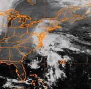
The broad and disorganized remnant low remained nearly stationary due to a ridge of high pressure to its north. Residual convection within the remnants of Henri remained disorganized, but forecasters kept watch for the potential for redevelopment. However, it moved inland near Cape Hatteras on September 12 before reorganizing. The remnants continued to the north, and the remnants of Henri finally dissipated on September 17.
Preparations
The National Hurricane Centre issued a Tropical Storm Warning from Englewood to Indian Pass, Florida while Henri was a tropical depression; however, warnings were discontinued by the time Henri made landfall. Flood warnings were issued across the state prior to the storm making landfall, with predictions of 5 to 10 inches (125–255 mm) of rainfall. As a result of the storm's approach, twelve shelters were placed on standby. Similarly, the Hurricane Shelter Information Hotline was placed on standby and ready to be activated within 10 minutes. Levy County officials declared a state of emergency. There, sand bags and sand were sent to Cedar Key, Yankeetown, and Inglis in anticipation for storm surge and flooding.
Impact
Henri dropped heavy rainfall along its path, with the worst of the flooding occurring in Delaware. The storm caused $19.6 million in damage (2003 USD), primarily in Delaware.
Florida, Bahamas, and Bermuda
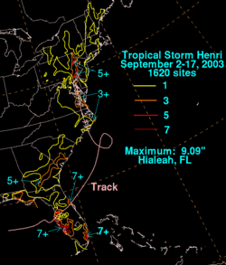
Prior to making landfall, the storm produced strong waves on the Florida west coast. Following a summer of tropical moisture in Florida, Henri brought more heavy rainfall to the saturated state, peaking at 9.09 in (230 mm) in Hialeah in the southeast portion of the state. Two other areas experienced over 7 in (180 mm), though most areas received only light rainfall. In Hernando County, a stationary thunderstorm dropped over 5 in (125 mm) of rain in around an hour. It caused a rapid flooding of roads, though quickly retreated. Damage was minor, due to lack of many homes in the area. A feeder band in Charlotte County dropped 7 in (180 mm) of rain in three hours, flooding numerous streets and homes. Throughout Florida, damage was minimal, and there were no deaths. However, lightning from a feeder band injured a man in Lee County, while an indirect injury occurred from a car crash due to hydroplaning.
In the Bahamas, where rainfall was needed, outer rainbands from Henri dropped around 1 inch (25 mm) of rain. There, winds gusted to 32 mph (51 km/h). Just days after Hurricane Fabian struck Bermuda, moisture from Henri brought thunderstorms and heavy rainfall and thunderstorms totaling to 2.44 inches (62 mm) at the airport. This hindered cleanup efforts, though caused no known damage.
Mid-Atlantic
In North Carolina, Virginia, and Maryland, rainfall was generally light, with the exception of a few areas receiving over 3 inches (75 mm). Henri produced greater amounts of rains Delaware and Pennsylvania, with a peak of 9.02 in (229 mm) in Hockessin. In Downingtown, Pennsylvania, over eight inches of rain fell in around six hours, while Doppler Radar estimated that Kennett Square received over 10 inches (255 mm) in a five hour period. The heavy rainfall lead to record discharge rates along the Red Clay Creek, which also had a record crest peaking at just below 26 feet (8 m). Parts of the river saw a 500-year flood, which has a 0.2% chance of occurring in any given year. Numerous rivers in southeastern Pennsylvania also crested above their flood stage.
In Delaware, the flooding damaged numerous houses, including 194 in the Glenville area. The rapid flooding trapped numerous people in their cars and homes, forcing at least one rescue by helicopter. Those people were evacuated to nearby schools. The severe flooding washed out most of a bridge in Hockessin and destroyed 6 railroad bridges in the Wilmington & Western Railroad, causing $5 million (2003 USD) in damage. The railroad bridge took 2½ years to be rebuilt. Greenbank Mill, a historic gristmill complex, saw $450,000 in damage. Damage in Delaware totaled to $16.1 million (2003 USD, $17.7 million 2006 USD).
Flash flooding in Pennsylvania resulted in 2,600 emergency 911 calls and around 100 rescues for cars or houses. The flooding destroyed 12 homes, and damaged 336, over half of them severely. Wet soil downed trees and power lines, causing power outages to 109,000 PECO Energy customers. High floodwaters damaged 22 bridges and closed 2 indefinitely, while the flooding closed several roads, including a portion of U.S. Highway 1 in Chadds Ford. Damage in Pennsylvania totaled to $3.5 million (2003 USD, $3.8 million 2006 USD). The impacts were severely compounded the following week by Hurricane Isabel across the region.
Aftermath
On September 23, just days after the storm moved through, President George W. Bush declared New Castle County, Delaware as a disaster area following the effects of Henri and later Hurricane Isabel. The declaration designated the affected citizens eligible for grants to pay for temporary housing, house repairs, and serious disaster-related expenses. The declaration also allowed for federal funding for 75% of the repair cost for replacing public facilities. By two months after the storm, 659 residents had applied for disaster aid through the Federal Emergency Management Agency, or FEMA, totaling to just over $1 million (2003 USD, $1.1 million 2006 USD). 141 small businesses applied for loans, totaling to around $2.5 million (2003 USD, $2.75 million 2006 USD). In addition, FEMA received 183 applications for public assistance, which would be used for rebuilding public roads and buildings. Over twenty volunteer organizations met to establish a long-term committee to find resources for disaster recovery needs. One goal sought by the committee was to find a permanent housing solution for every one who was displaced from their houses from the storms. Volunteers also helped remove ruined appliances and furniture to local landfills, totaling to more than 300 tons. State and county governments in Delaware purchased 171 homes following the damage in the Glenville area. This is the highest number of houses purchased in Delaware due to storm damage. The house purchasing was done to mitigate the flood damage by restoring the area as a wetland.
On September 26, President Bush also declared Chester County, Pennsylvania as a disaster area following the damage of Henri, Tropical Storm Isabel, and severe flooding unrelated to either tropical cyclone. By a month after the declaration, 342 homeowners and business owners applied for disaster aid, totaling to around $600,000 (2003 USD, $660,000 2006 USD).
Because the damage was localized and overall minimal, the name Henri was not retired, and it is scheduled to be used next the 2009 season.


