2003 Atlantic hurricane season
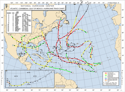
Season summary map |
| First storm formed: |
April 20, 2003 |
| Last storm dissipated: |
December 11, 2003 |
| Strongest storm: |
Isabel - 915 mbar (27.01 inHg), 145 knots (165 mph) |
| Total storms: |
16 |
| Major storms ( Cat. 3+): |
3 |
| Total damage: |
$4 billion (2003 USD)
$4.3 billion (2005 USD) |
| Total fatalities: |
92 |
|
|
Atlantic hurricane seasons
2001, 2002, 2003, 2004, 2005 |
|
|
The 2003 Atlantic hurricane season officially began on June 1, 2003, and lasted until November 30, 2003. These dates conventionally delimit the period of each year when most tropical cyclones form in the Atlantic basin, although the season technically lasted from April 20 to December 11 due to out-of-season storm activity caused by Tropical Storms Ana and Peter.
The season was tied for the sixth most active on record, behind the 2005, 1933, 1995, 1887, and 1969 seasons, and tied with the 1936 season. Two unusual events happened in the 2003 season. The first was the formation of Tropical Storm Ana, the first Atlantic tropical storm on record to form in April. The other was the December formation of Tropical Storms Odette and Peter, making 2003 the first time two Atlantic tropical storms formed in December since the 1887 Atlantic hurricane season.
Other notable storms include Hurricane Fabian, Hurricane Isabel, and Hurricane Juan. Fabian struck Bermuda as a Category 3 hurricane, the first direct hit since 1926, causing $300 million in damage. Isabel, which reached Category 5 strength, made landfall on the Outer Banks of North Carolina, causing widespread damage across the Mid-Atlantic amounting to $3.7 billion with 16 direct deaths. Lastly, Juan caused considerable destruction to Nova Scotia, particularly Halifax, as a Category 2 hurricane, the first hurricane of significant strength to hit the province since 1893. All three names were retired.
Storms
Tropical Storm Ana
|
|
|
|
| Duration |
April 20— April 24 |
| Intensity |
60 mph (95 km/h), 994 mbar |
Ana formed as a subtropical storm on April 20 as a non-tropical low, and began taking on tropical characteristics. By April 21, Subtropical Storm Ana had developed a warm core and was designated a tropical storm. By April 24 it had become extratropical, and was absorbed by a frontal system near Portugal two days later. It was the only Atlantic storm ever to have formed in April in recorded history. A subtropical storm in the 1992 Atlantic hurricane season was the first recorded tropical or subtropical cyclone in April, although there have likely been other cyclones that were undetected.
Tropical Depression Two
|
|
Tropical Depression Two |
TD |
|
|
|
| Duration |
June 11— June 12 |
| Intensity |
35 mph (55 km/h), 1008 mbar |
A low pressure system formed from a tropical wave about 1500 miles (1075 km) east of the Lesser Antilles and developed into a tropical depression on June 11. It moved west by north and reached a peak strength of 35 mph and minimum central pressure of 1008 mb. It experienced strong shear and dissipated on June 12 without strengthening to a tropical storm. It was only the third storm to develop east of the Lesser Antilles in June since 1967.
Tropical Storm Bill
|
|
|
|
| Duration |
June 29— July 2 |
| Intensity |
60 mph (95 km/h), 997 mbar |
On June 29, a low pressure area drifting north over the southern Gulf of Mexico organized into a tropical depression over the Yucatán Peninsula, an unusual occurrence as tropical cyclones don't usually form over land. The depression moved offshore and strengthened into Tropical Storm Bill. Initially disorganized, it moved northward, steadily strengthening while becoming more tropical. Bill crossed the gulf, and made landfall west of Cocodrie, Louisiana with winds of 60 mph. Although a relatively weak storm, Bill is blamed for four deaths and $50 million in estimated damages.
Hurricane Claudette
|
|
|
|
| Duration |
July 7— July 17 |
| Intensity |
90 mph (145 km/h), 979 mbar |
The system that became Claudette was recognized as a tropical depression near the Windward Islands on July 7. By July 11, Claudette had reached the Yucatán Peninsula. A few hours after landfall at Puerto Morelos, Claudette emerged over the waters of the Gulf of Mexico. Claudette would restrengthen, and made landfall a second time on July 15 at Matagorda Island near Port O'Connor, Texas as a strong Category 1 storm. After its final landfall, Claudette remained at tropical storm strength for more than a day, an unusual occurrence. Most tropical systems weaken rapidly after landfall, as they are separated from the warm waters that power them.
Claudette was responsible for one direct death, from a falling tree. Inland towns in Texas, such as Goliad sustained significant wind damage. Estimated US damage was $180 million. No significant damage was reported from Mexico.
Hurricane Danny
|
|
|
|
| Duration |
July 16— July 21 |
| Intensity |
75 mph (120 km/h), 1000 mbar |
Hurricane Danny was named on July 17 in the open ocean east of Bermuda from a tropical wave. Initially expected to remain a tropical depression, Danny began the northeastward leg of an anti-cyclonic loop around an area of high pressure in the central Atlantic, and strengthened over unusually favorable conditions in the north Atlantic for July. The storm reached hurricane strength on July 19, but weakened 24 hours later over the cool waters of the north Atlantic. By July 21 Danny had lost its identity as a tropical cyclone. Danny caused no reported damage and never threatened land.
Tropical Depression Six
|
|
Tropical Depression Six |
TD |
|
|
|
| Duration |
July 19— July 21 |
| Intensity |
35 mph (55 km/h), 1010 mbar |
A low pressure system formed from a tropical wave about 1035 miles (1665 km) east of the Lesser antilles and developed into a tropical depression on July 19. It moved west by north and reached a peak strength of 35 mph and minimum central pressure of 1010 mb. It never had a closed circulation, and it dissipated on July 21 without strengthening to a tropical storm. The northern part split off and became Tropical Depression Seven.
Tropical Depression Seven
|
|
Tropical Depression Seven |
TD |
|
|
|
| Duration |
July 25— July 27 |
| Intensity |
35 mph (55 km/h), 1016 mbar |
A low pressure system formed from the northern remnants of Tropical Depression Six about 60 miles (95 km) east of Daytona Beach, Florida and developed into a tropical depression on July 25. It moved northwest and reached a peak strength of 35 mph and minimum central pressure of 1016 mb. It formed very close to land and never developed into a tropical storm, making landfall near St. Catherines Island, Georgia on July 26 and it dissipated over Georgia on July 27.
Hurricane Erika
|
|
|
|
| Duration |
August 14— August 17 |
| Intensity |
75 mph (120 km/h), 986 mbar |
Hurricane Erika formed out of a non-tropical low first spotted 1000 nm east of Bermuda on August 9. As it approached Florida on August 14, the low began taking on tropical characteristics, and almost developed a closed circulation. When the low emerged into the Gulf of Mexico, the presence of a fully closed circulation and active convection resulted in a classification as Tropical Storm Erika. A high pressure system over the southern United States caused Erika to move quickly westerward. On August 16, Erika's motion slowed and the storm intensified. Landfall was at the Mexican town of Boca San Rafael, about 40 miles (65 km) south of Matamoros, Tamaulipas.
Erika was not classified as a hurricane while active. A post-storm analysis of radar data revealed sustained hurricane force winds just before landfall, and the storm was upgraded after the fact.
Erika was responsible for two deaths due to flooding in Mexico. Large amounts of flood-related damage were reported in north-eastern Mexico. Minor coastal damage and beach erosion occurred in South Texas. Damage was limited to one building experiencing roof damage, with total damage in Texas amounting to $10,000 (2003 USD).
Tropical Depression Nine
|
|
Tropical Depression Nine |
TD |
|
|
|
| Duration |
August 21— August 22 |
| Intensity |
35 mph (55 km/h), 1007 mbar |
A Tropical Depression formed from a low pressure created by a tropical wave on August 21, about 160 miles (255 km) south of Puerto Rico. It had maximum strength of 35 mph and a minimum pressure of 1007 mbar. It was expected gain tropical storm status, but wind shear from from the southwest caused it to dissipate on August 22.
Hurricane Fabian
|
|
|
|
| Duration |
August 25— September 8 |
| Intensity |
145 mph (230 km/h), 939 mbar |
Fabian was a powerful Cape Verde-type hurricane that formed in late August in the tropical Atlantic Ocean. It moved generally west-northwestward, peaking at 145 mph before turning to the northwest. On September 5, Fabian hit Bermuda at Category 3 strength. Although it was not technically a landfall, Fabian's eyewall passed directly over the island, causing severe damage. The hurricane continued to the northeast, became extratropical on September 8, and dissipated on the 9th in the north Atlantic. Fabian was responsible for eight deaths, and caused an estimated 300 million (2003 USD) in damage to Bermuda, making it the worst Bermuda hurricane since 1926. Because of its destruction, the name was retired after this season, and will be replaced by Fred in 2009.
Tropical Storm Grace
|
|
|
|
| Duration |
August 30— September 2 |
| Intensity |
40 mph (65 km/h), 1007 mbar |
Tropical Storm Grace formed from a disturbance in the central Gulf of Mexico on August 30. Grace was an ill-defined storm which formed a second circulation center. The second, stronger centre moved onshore near San Luis Pass at the western end of Galveston Island on August 31. The storm quickly weakened and merged with a frontal system in eastern Oklahoma on September 2. While Grace was responsible for heavy rainfall along the Texas coast, damage was minor and totaled to $113,000 (2003 USD). There were no deaths.
Tropical Storm Henri
|
|
|
|
| Duration |
September 3— September 8 |
| Intensity |
60 mph (95 km/h), 997 mbar |
Henri formed from a tropical wave in the Gulf of Mexico on September 5. Under the influence of a mid-latitude trough, it moved eastward. Despite strong wind shear, Henri's winds quickly increased to 60 mph, but fell off to 30 kt before landfall as a tropical depression near Clearwater, Florida. It crossed the state, and dissipated on the 9th off the North Carolina coast due to vertical shear. The extratropical renmant moved northward, and moved inland on September 12.
Henri was responsible for up to 10 inches of rainfall across Florida, but damage was minimal. The remnants of Henri caused heavy flooding across the Mid-Atlantic of up to 10 inches. In Delaware, 194 homes were damaged from the flooding. The rainfall caused rivers to exceed flood stage, including the Red Clay Creek in Delaware which peaked at 17.27 feet. Damage totaled to $19.5 million (2003 USD), though no deaths occurred.
Hurricane Isabel
|
|
|
|
| Duration |
September 6— September 20 |
| Intensity |
165 mph (270 km/h), 915 mbar |
A tropical wave off the coast of Africa was named Tropical Storm Isabel on September 6. The storm moved westward and intensified to hurricane strength. By September 11, Isabel had reached Category 5 strength, with winds of 165 mi/h. Isabel would remain at or near Category 5 for 5 days while moving west-northwest across the Atlantic. On September 15, as Isabel approached the Bahamas, vertical wind shear increased, and Isabel began to weaken. Now on a more northern track, Isabel made landfall near Drum Inlet, North Carolina on September 18 at Category 2 strength. Isabel remained a hurricane until it reached southern Virginia, and was eventually absorbed by a larger system over far northern Ontario, Canada, near James Bay, maintaining at least tropical storm intensity for most of the way up.
Isabel was directly responsible for 16 deaths, 10 in Virginia. Indirect deaths were more numerous, with 35 people losing their lives across nine states, the District of Columbia and Canada. Widespread damage was reported, most in Virginia and not in North Carolina as one would expect. Total damages were estimated at $3.37 billion, with two-thirds of that total applying to Virginia.
Tropical Depression Fourteen
|
|
Tropical Depression 14 |
TD |
|
|
|
| Duration |
September 8— September 10 |
| Intensity |
35 mph (55 km/h), 1007 mbar |
A tropical wave off of Africa became a Tropical Depression on September 8, about 290 miles (465 km) southeast of the Cape Verde Islands. It had a maximum strength of 35 mph, and minimum pressure of 1007 mbar. This depression was forecast to become a tropical storm for some of its life, and was even projected to become a minimal hurricane when it first formed. However, an upper level low created shear from the south, which caused it to dissipate on September 10.
Hurricane Juan
|
|
|
|
| Duration |
September 24— September 29 |
| Intensity |
105 mph (170 km/h), 969 mbar |
A large upper-level low combined with a westward moving tropical wave developed into a tropical depression on September 24. Initially subtropical in nature yet classified tropical, it strengthened and reached tropical storm strength on September 25, while 300 nm southeast of Bermuda. Juan moved northward, strengthening into a hurricane on the 26th and peaking at 105 mph on the 27th, due to warmer than usual water temperatures. Juan continued northward and made landfall near Halifax, Nova Scotia as a strong Category 2 hurricane with sustained winds of 100 mph. Juan was responsible for eight deaths, and, with a damage toll of $200 million, is considered the worst hurricane to hit Halifax in 110 years.
Hurricane Kate
|
|
|
|
| Duration |
September 25— October 7 |
| Intensity |
125 mph (205 km/h), 952 mbar |
Kate formed from a depression in the open Atlantic on September 27. Kate followed an unusual path, often changing directions radically. The system took the NHC off track. Kate eventually strengthened to a strong Category 3 hurricane, and slipped southeast of Newfoundland while a Category 1 hurricane. It eventually headed northward and became extratropical. No significant damage or fatalities were reported in relation to Kate, although heavy rain was reported in coastal areas of southeastern Newfoundland. Hurricane Kate was most remembered for the fear it brought to the Canadian Hurricane Centre as it neared Canada, especially being less than a week after Hurricane Juan.
Tropical Storm Larry
|
|
|
|
| Duration |
October 1— October 6 |
| Intensity |
65 mph (100 km/h), 993 mbar |
A westward moving tropical wave developed a weak low pressure system to the east of the Yucatán Peninsula on September 27. It moved westward, and became associated with a cold front. An extratropical storm formed late on September 30, and while drifting over the warm waters of the Bay of Campeche, it became Tropical Storm Larry on October 1. A strong ridge of high pressure from Florida to Texas prevented any northward motion, leaving Larry to nearly stall. Larry meandered slowly southward, steadily strengthening to a 65 mph tropical storm. The storm made landfall in Tabasco near Paraiso on the 6th, and dissipated later that day. The renmant low crossed over into the Pacific where it dissipated on October 7. Five deaths were officially reported, due to inland flooding.
Tropical Storm Mindy
|
|
|
|
| Duration |
October 10— October 14 |
| Intensity |
45 mph (75 km/h), 1002 mbar |
A strong tropical wave with a weak circulation that had just passed over the Dominican Republic was named Tropical Storm Mindy on October 10. It moved to the west-northwest, where it briefly reached a peak of 45 mph winds. Conditions were never favorable for development, and on October 12 Mindy weakened to a depression. Two days later, the storm had dissipated completely. Mindy caused significant rainfall over Puerto Rico and the Dominican Republic, but caused no reported damages or fatalities.
Tropical Storm Nicholas
|
|
Tropical Storm Nicholas |
TS |
|
|
|
| Duration |
October 13— October 23 |
| Intensity |
70 mph (110 km/h), 990 mbar |
Tropical Storm Nicholas formed on October 14 in the southern Atlantic. Due to continual wind shear, Nicholas would never undergo significant strengthening. Nicholas slowly travelled northwest, and became extratropical on October 23.
The extratropical low that was Nicholas performed two anticyclonic loops while continuing to move westward, and was finally absorbed into a non-tropical low on November 1. There are no fatalities or damages associated with Tropical Storm Nicholas.
Tropical Storm Odette
|
|
|
|
| Duration |
December 4— December 7 |
| Intensity |
65 mph (95 km/h), 993 mbar |
Odette was a rare December tropical storm (the first since Hurricane Lili in 1984) that formed on December 4, days after the official end of hurricane season. Odette strengthened and made landfall near Cabo Falso in the Dominican Republic on December 6 as a moderately strong tropical storm. A day later, Odette became extratropical, and eventually merged with a cold front.
Eight deaths were directly attributed to this tropical storm in the Dominican Republic due to mudslides or flash flooding. In addition, two deaths were indirectly caused by the storm. Approximately 35% of the nation's banana crop was destroyed. Fortunately, little damage occurred in Haiti.
Tropical Storm Peter
|
|
|
|
| Duration |
December 7— December 11 |
| Intensity |
70 mph (110 km/h), 990 mbar |
Peter was a short-lived storm, primarily notable for being the second December storm of the season, the first time this has occurred since the 1887 season. It is also notable for being only the second storm to reach the 'P' name since naming began in the Atlantic in 1950, and one of only three storms total to do this. The other storms were Pablo in the 1995 season and Philippe in the 2005 season.
Peter formed as a subtropical storm on December 7 from an extratropical gale. By December 9, Peter had become a strong tropical storm, nearly reaching hurricane strength. The organization would not last, as Peter became an extratropical low on December 11 and was absorbed by a cold front. No deaths or damages are associated with Peter. The formation of Peter made 2003 the busiest season since 1995.
Accumulated Cyclone Energy (ACE) Ranking
| ACE (104 kt2) – Storm |
| 1 |
63.28 |
Isabel |
9 |
2.76 |
Odette |
| 2 |
43.16 |
Fabian |
10 |
2.63 |
Ana |
| 3 |
21.89 |
Kate |
11 |
2.10 |
Erika |
| 4 |
9.40 |
Juan |
12 |
1.39 |
Bill |
| 5 |
9.24 |
Claudette |
13 |
1.10 |
Peter |
| 6 |
7.25 |
Nicholas |
14 |
0.85 |
Mindy |
| 7 |
4.56 |
Danny |
15 |
0.53 |
Henri |
| 8 |
4.15 |
Larry |
16 |
0.49 |
Grace |
The table on the right shows the ACE for each storm in the season. The ACE is, broadly speaking, a measure of the power of the hurricane multiplied by the length of time it existed for, so hurricanes that lasted a long time (such as Isabel and Fabian) have higher ACEs. Isabel was one of the very few hurricanes since 1950 to have an ACE of over 50 104 kt2.
Season impact
2003 Atlantic hurricane statistics
| Storm Name |
Active Dates |
Storm category at peak intensity |
Max Wind ( mph) |
Min. Press. ( mbar) |
ACE |
Landfall(s) |
Damage (millions USD) |
Deaths |
| Where |
When |
Wind ( mph) |
| Ana |
20 - 24 April |
Tropical Storm |
60 |
994 |
2.63 |
none |
0 |
2 |
| Two |
1 June |
Tropical Depression |
35 |
1008 |
0 |
none |
0 |
0 |
| Bill |
28 June - 2 July |
Tropical Storm |
60 |
997 |
1.39 |
King Lake, Louisiana |
June 30 |
60 |
50 |
4 |
| Claudette |
8 - 17 July |
Category 1 Hurricane |
90 |
979 |
9.24 |
Puerto Morelos, Mexico |
11 July |
50 |
180 |
1 (2) |
| Matagorda Island, Texas |
15 July |
90 |
| Danny |
16 - 21 July |
Category 1 Hurricane |
75 |
1000 |
4.56 |
none |
0 |
0 |
| Six |
19 - 21 July |
Tropical Depression |
35 |
1010 |
0 |
none |
0 |
0 |
| Seven |
25 - 27 Jul |
Tropical Depression |
35 |
1016 |
0 |
St. Catherines Island, Georgia |
26 July |
30 |
0 |
0 |
| Erika |
14 - 17 Aug |
Category 1 Hurricane |
75 |
986 |
2.10 |
Boca San Rafael, Mexico |
16 August |
75 |
.01+ |
2 |
| Nine |
21 - 22 August |
Tropical Depression |
35 |
1007 |
0 |
none |
0 |
0 |
| Fabian |
27 Aug - 8 Sept |
Category 4 Hurricane |
145 |
939 |
43.16 |
Bermuda |
5 September |
115 |
300 |
8 |
| Grace |
30 Aug - 2 Sept |
Tropical Storm |
40 |
1007 |
0.49 |
San Luis Pass, Texas |
31 August |
40 |
.1 |
0 |
| Henri |
3 - 8 Sept |
Tropical Storm |
60 |
997 |
0.53 |
Clearwater, Florida |
6 Sept |
35 |
20.6 |
0 |
| Isabel |
6 - 19 Sept |
Category 5 Hurricane |
165 |
915 |
63.28 |
Drum Inlet, North Carolina |
18 Sept |
105 |
3370 |
16 (34) |
| Fourteen |
8 - 10 Sept. |
Tropical Depression |
35 |
1007 |
0 |
none |
0 |
0 |
| Juan |
24 - 29 Sept |
Category 2 Hurricane |
105 |
969 |
9.40 |
near Halifax, Nova Scotia |
29 Sept |
100 |
200 |
4 (4) |
| Kate |
25 Sept - 7 Oct |
Category 3 Hurricane |
130 |
952 |
21.89 |
none |
0 |
0 |
| Larry |
1 - 6 Oct |
Tropical Storm |
65 |
993 |
4.15 |
Paraiso, Mexico |
5 Oct |
60 |
53.6 |
5 |
| Mindy |
10 - 14 Oct |
Tropical Storm |
45 |
1002 |
0.85 |
none |
.05 |
0 |
| Nicholas |
13 - 23 Oct |
Tropical Storm |
70 |
990 |
7.25 |
none |
0 |
0 |
| Odette |
4 - 7 Dec |
Tropical Storm |
65 |
993 |
2.76 |
Cabo Falso, Dominican Republic |
6 Dec |
60 |
8 |
8 (2) |
| Peter |
7 - 11 Dec |
Tropical Storm |
70 |
990 |
1.10 |
none |
0 |
0 |
| Season Aggregates |
| 21 cyclones |
April 21
- Dec. 11 |
|
165 |
915 |
174.68 |
12 Landfalls |
4200 |
48 (44) |
Storm names
The following names were used for named storms that formed in the north Atlantic in 2003. The names not retired from this list will be used again in the 2009 season. This is the same list used for the 1997 season. Storms were named Larry, Mindy, Nicholas, Odette, and Peter for the first time in 2003. Names that were not assigned are marked in gray.
- Ana
- Bill
- Claudette
- Danny
- Erika
- Fabian
- Grace
|
|
- Odette
- Peter
- Rose (unused)
- Sam (unused)
- Teresa (unused)
- Victor (unused)
- Wanda (unused)
|
Retirement
The World Meteorological Organization retired three names in the spring of 2004: Fabian, Isabel, and Juan. They will be replaced in the 2009 season by Fred, Ida, and Joaquin.


