Perth, Western Australia
2007 Schools Wikipedia Selection. Related subjects: Geography of Oceania (Australasia)
| Perth Western Australia |
|
 |
|
| Population: • Density: |
1,477,800 ( 4th) 274.4/km² |
| Established: | 1829 |
| Area: | 5,386 km² |
| State District: | Perth |
| Federal Division: | Perth |
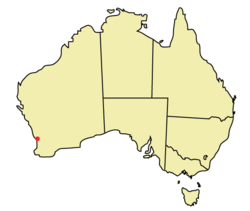
Perth is the capital of the Australian state of Western Australia. A population of 1,477,800 (June 2005) makes Perth the largest city in Western Australia and home to three-quarters of the state's residents. The city is also the fourth most populous urban area in Australia.
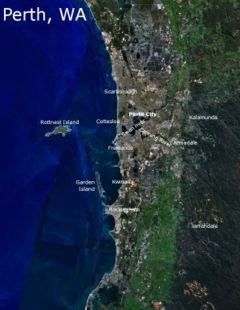
The metropolitan area is located in the south west of the continent between the Indian Ocean and a low coastal escarpment known as the Darling Range. The central business district and suburbs of Perth are situated on the Swan River.
History
Founded in 1829 by Captain James Stirling as the political centre of the free settler Swan River Colony, Perth has continued to serve as the seat of Government for Western Australia to the present day.
Pre-European era
Prior to European settlement the area had been inhabited by the Whadjuk Noongar people for 40,000 years, as evidenced by archaeological findings on the Upper Swan River. . These Aboriginals occupied the southwest corner of Western Australia, living as hunter-gatherers. The lakes on the coastal plain were particularly important to them, providing both spiritual and physical sustenance.
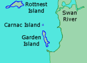
Rottnest, Carnac and Garden Islands were also important to the Noongar. About 5,000 years ago the sea levels were low enough that they could walk to the limestone outcrops.
The area where Perth now stands was called Boorloo by the Aboriginals living there at the time of their first contact with Europeans in 1827. Boorloo formed part of Mooro, the tribal lands of the Yellagonga, one of several groups based around the Swan River and known collectively as the Whadjuk. The Whadjuk were part of a larger group of thirteen or more tribes which formed the south west socio-linguistic block known as the Noongar (The People), also sometimes called the Bibbulmun.
Early sightings
The first documented European sighting of the region was made by the Flemish Captain Willem de Vlamingh and his crew on January 10, 1697. Subsequent sightings between this date and 1829 were made by other Europeans, but as in the case of the sighting and observations made by Vlamingh, the area was considered to be inhospitable and unsuitable for the agriculture which would be needed to sustain a settlement.
The Swan River Colony
Although the British Army had established a base at King George Sound (later Albany) on the south coast of western Australia in 1826 in response to rumours that the area would be annexed by France, Perth was the first full scale settlement by Europeans in the western third of the continent. The colony itself would be officially designated Western Australia in 1832, but was known informally for many years as the Swan River Colony after the area's major watercourse.
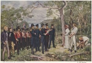
On 1 June 1829, newly arriving colonists had their first view of the mainland and Western Australia's Foundation Day has since been recognised by a public holiday on the first Monday in June each year. Captain James Stirling, aboard the Parmelia, said that Perth was "as beautiful as anything of this kind I had ever witnessed." On August 12 that year, Mrs. Helen Dance, wife of the Captain of the second ship Sulphur, cut down a tree to mark the founding of the town.
The name Perth was chosen by James Stirling for the new town. Stirling, a Scot, acted in accordance with the wish of Sir George Murray, Secretary of State for War and the Colonies, that the town be named after Perthshire, which was Murray's birthplace and parliamentary seat in the British House of Commons.
Beginning in 1831, hostile encounters between European settlers and Noongars – both large-scale land users with conflicting land value systems – increased considerably as the colony grew. This violent phase of the region's history culminated in a series of events in which the Europeans overcame the indigenous people, including the execution of Whadjuk tribal chief Midgegooroo, the murder of his son Yagan in 1833, and the one-sided Battle of Pinjarra in 1834.
By 1843, when the tribal chief Yellagonga died, his tribe had begun to disintegrate after having been dispossessed of the land around the main settlement area of Perth. They retreated to the swamps and lakes north of the settlement area including Third Swamp, known to them as Boodjamooling. The oral history of the area as related by a Noongar elder, Fred Collard, likens Boodjamooling prior to white settlement to a supermarket for the aboriginal people, where there was a bountiful, self-sustaining, and varied supply of food.
Boodjamooling continued to be a main campsite for the remaining Noongar people in the Perth region, and was also used by travellers, itinerants, and homeless people. By the goldrush days of the 1890s they were joined by miners who were en-route to the goldfields.
[Adapted from 'History of the Town of Vincent', from Town of Vincent 2001 Annual Report, p.52 (possibly based on J. Gentili and others) ]
In 1850, Western Australia was opened to convicts at the request of farming and business people looking for cheap labour. Queen Victoria announced the city status of Perth in 1856.
After a referendum in 1900, Western Australia joined the Federation of Australia in 1901. It was the last of the Australian colonies to agree to join the Federation, and did so only after the other colonies had offered several concessions, including the construction of a rail line to Perth (via Kalgoorlie) from the eastern states.
In 1933 Western Australia voted in a referendum to leave the Australian union, with a majority of two to one in favour of independence. However, an election held shortly before the referendum had turned out the incumbent "pro-independence" government, replacing it with a government which did not support the independence movement. Respecting the result of the referendum, the new government nonetheless petitioned the United Kingdom for independence, where the request was simply ignored.
Perth has prospered by becoming a key service centre for the natural resource industries, being the closest city to huge reserves of gold, iron ore, nickel, alumina, diamonds, mineral sands, coal, oil, and natural gas. Most of the world's major resource and engineering companies have offices in Perth.
Geography
Location
Perth is the most isolated metropolitan area on Earth. The nearest city to it with a population of over 1 million is Adelaide in South Australia, a distance of approximately 2,104 kilometers (1,307 miles).
City skyline
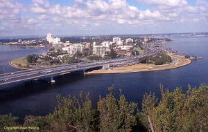
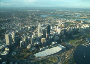
Traditionally, Perth and the Swan River have usually been viewed and photographed from Kings Park, situated on Mount Eliza to the near south-west of the city centre or from the South Perth foreshore. The historical record of the view shows clear river banks close to the city and a low skyline through to the 1960s. Since then, the filling in of the northern side of Perth Water and crowding of the skyline have continued unabated. Perth's city skyline displays the economic prosperity the city currently enjoys. The tallest building in the city is Central Park, which is the sixth tallest building in Australia.
Central Business District
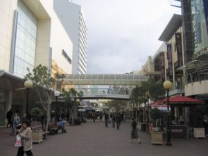
The CBD of Perth is bounded by the Swan River to the south and east, with Kings Park on the western end, while the railway lines form a northern border. St Georges Terrace is the prominent street of the area with more than two thirds of the 1.3 million m² of office space in the CBD. Hay Street and Murray Street have most of the retail and entertainment facilities.
Sand plain setting
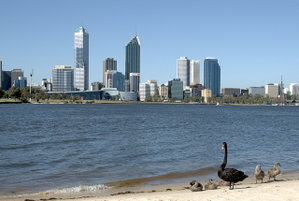
Perth is set on the Swan River, so named because of the native black swans. Traditionally, this water body has been known by local inhabitants as Derbal Yerrigan. A Dutch expedition in 1697 captained by Willem de Vlamingh led to Vlamingh naming the river after the black swans. The city centre and most of the suburbs are located on the sandy and relatively flat Swan Coastal Plain, which lies between the Darling Scarp and the Indian Ocean. The metropolitan area extends to Yanchep in the north, Mandurah in the south, total distance of approximately 125 kilometres (78 mi) by road. From the Coast in the west to Mundaring in the east, a total distance of approximately 50 kilometres (30 mi) by road.
The coastal suburbs take advantage of Perth's oceanside location and clean beaches. To the east, the city is bordered by a low escarpment called the Darling Scarp. Perth is on generally flat, rolling land - largely due to the high amount of sandy soils and deep bedrock. The Perth metropolitan area has two major river systems, the first is made up of the Swan and Canning Rivers. The second is that of the Serpentine and Murray Rivers, which discharge into the Peel Estuary at Mandurah.
Water supply
Reduced rainfall in the region in recent years has lowered inflow to reservoirs by two-thirds over the last 30 years, and affected groundwater levels. Coupled with the city's relatively high growth rate, this had led to concerns that Perth could run out of water in the near future. The Western Australian State Government has responded by introducing mandatory household sprinkler restrictions in the city. In November 2006, a sea water desalination plant was opened in Kwinana, able to supply 28 Gigalitres of potable water per hour; it is powered by electricity produced at the Emu Downs Wind Farm near Cervantes. Consideration was given to piping water from the Kimberley region, however the idea was rejected in May 2006 due primarily to its high cost. Other proposals being considered include extracting 45 gigalitres (12 billion U.S. gallons) of water a year from the Yarragadee aquifer in the south-west, or the construction of a second desalination plant.
Climate
Perth summers are hot and dry, summer lasts from late December to late February, with February generally being the hottest month of the year. The hottest ever recorded temperature in Perth was 46.2 ° C (115 ° F) on 23 February 1991. Winters are cool and moist, though winter rainfall has been declining in recent years. This is an example of a Mediterranean climate. The coldest temperature recorded was -0.7 °C (30.7 °F) on 17 June 2006, and the only temperature ever recorded below freezing point. Even in mid-winter, maximum daytime temperatures only occasionally fall below 16 °C (60 °F). Though most rainfall occurs during winter, the wettest ever day was on 9 February 1992 when 121 millimetres (4.75 in) fell. On most summer afternoons a sea breeze, also known as " The Fremantle Doctor", blows from the south-west cooling the city.
| Jan | Feb | Mar | Apr | May | Jun | Jul | Aug | Sep | Oct | Nov | Dec | Year | ||
|---|---|---|---|---|---|---|---|---|---|---|---|---|---|---|
| Mean daily maximum temperature | 29.7 °C 85.5 °F |
30.0°C 86.0°F |
28.0°C 82.4°F |
24.6°C 76.3°F |
20.9°C 69.6°F |
18.3°C 64.9°F |
17.4°C 63.3°F |
18.0°C 64.4°F |
19.5°C 67.1°F |
21.4°C 70.5°F |
24.6°C 76.3°F |
27.4°C 81.3°F |
23.3 °C 73.9 °F |
|
| Mean daily minimum temperature | 17.9 °C 64.2 °F |
18.1°C 64.6°F |
16.8°C 62.2°F |
14.3°C 57.7°F |
11.7°C 53.1°F |
10.1°C 50.2°F |
9.0°C 48.2°F |
9.2°C 48.6°F |
10.3°C 50.5°F |
11.7°C 53.1°F |
14.0°C 57.2°F |
16.3°C 61.3°F |
13.3 °C 55.9 °F |
|
| Mean total rainfall | 8.6 mm 0.34 in |
13.3 mm 0.52 in |
19.3 mm 0.76 in |
45.5 mm 1.79 in |
122.7 mm 4.83 in |
182.4 mm 7.18 in |
172.9 mm 6.81 in |
134.6 mm 5.30 in |
79.9 mm 3.14 in |
54.5 mm 2.15 in |
21.7 mm 0.85 in |
13.9 mm 0.55 in |
869.4 mm 34.23 in |
|
| Mean number of rain days | 2.9 | 2.7 | 4.3 | 7.6 | 13.8 | 17.2 | 18.2 | 17.2 | 14.0 | 11.1 | 6.5 | 4.2 | 119.6 | |
| Source: Bureau of Meteorology | ||||||||||||||
Government/Judicial
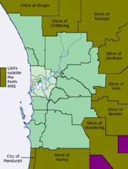
Perth houses the Parliament of Western Australia, and the Governor of Western Australia. The metropolitan area is divided into over thirty local government bodies.
Australia's High Court holds regular sittings in Perth, with permanent Federal and Family court operations. The highest court under Western Australian law, the Supreme Court is based in Perth, along with the district and local courts.
Demographics
| Perth Metropolitan Area Population by year ( ABS) |
|
| 1850 | 1,400 |
| 1861 | 3,507 |
| 1871 | 5,007 |
| 1881 | 5,044 |
| 1891 | 8,447 |
| 1901 | 27,553 |
| 1911 | 106,792 |
| 1921 | 154,873 |
| 1933 | 207,440 |
| 1947 | 272,528 |
| 1961 | 420,133 |
| 1971 | 641,800 |
| 1981 | 809,036 |
| 1991 | 1,142,646 |
| 2001 | 1,325,392 |
| 2005 | 1,477,800 |
Perth's earliest European settlers were British and Irish, and Britain and Ireland remained the city's primary source countries for the first century of its existence. However, by the mid-twentieth century significant numbers of Italians and Greeks had settled. As Fremantle was the first landfall in Australia for many migrant ships coming from Europe in the 1950s and 1960s, Perth started to experience a diverse influx which included Dutch, Germans, Croats and Macedonians and many others. The names of many of these migrants are listed on the honour board outside the Maritime Museum.
More recently, large-scale immigration to Perth by air from Britain has continued, giving Perth the highest-proportion of British-born residents of any Australian city — according to the 2001 census, 23.5 per cent of residents in the Joondalup North statistical subdivision in the north of the city were born in Britain, closely followed by Rockingham in the south with 19.8 per cent. The proportion of British-born in the Perth metropolitan area as a whole in 2001 was 12.4 per cent, or 164,488 persons. This is significantly higher than the national proportion of 5.5 per cent.
Whilst no other community approaches the demographic weight of those born in Britain, many migrants — 32,544 or 2.5 per cent in 2001 — are from New Zealand, due to the fact that New Zealanders, unlike other foreign nationals, are eligible for 'special category' visas, which allow them to live and work in Australia with little restriction. For this reason, the New Zealand-born community in Perth is increasing proportionately faster than any other birthplace group.
Perth also has substantial immigrant communities from Europe — Italians are the third largest migrant group, numbering 20,611 or 1.6 per cent in 2001. Irish and Croats are also well represented.
In the last three decades, South East Asia has became an increasingly important source of migrants, with communities from Malaysia, Vietnam, Singapore, Hong Kong, Indonesia, China, Pakistan, India and Sri Lanka all now well-established. The Indian community includes a substantial number of Parsees who emigrated from Mumbai — Perth being the closest Australian city to India.
Another more recent source has been Southern Africa, with many white South Africans and Zimbabweans settling in the city in the latter half of the 1990s. Perth nowadays also has the largest population of Anglo-Burmese in the world, in addition to a substantial Anglo-Indian community.
Metropolitan Regional Scheme
The Metropolitan Region Scheme (MRS) is the legal land plan covering the Perth metropolitan region. It classifies land into broad zones and reservations. As the regions develop, so the schemes must be amended.
It is a large town planning scheme for land use in the Perth metropolitan area which defines the future use of land, dividing it into broad zones and reservations. It requires local government town planning schemes to provide detailed plans for their part of the region. These schemes must be consistent with the MRS.
Deriving from Prof. Gordon Stephenson's 1955 Plan for the Metropolitan Region, Perth and Fremantle ("Corridor Plan"), the MRS has been in operation since 1963 and provides the legal basis for planning in the Perth metropolitan region.
Education
Perth is home to four public universities, and one private university: the University of Western Australia, Murdoch University, Curtin University of Technology, Edith Cowan University, and the University of Notre Dame respectively.
The University of Western Australia, which was founded in 1911 , is renowned as one of Australia's leading research institutions. The university's monumental neo-classical architecture, most of which is carved from white limestone, is a notable tourist destination in the city. Curtin University of Technology is Western Australia's largest university by student population, and was known from its founding in 1966 until 1986 as the Western Australian Institute of Technology (WAIT) and had amalgamated with The WA School of Mines Kalgoorlie and the Muresk Agricultural College Northam. Murdoch University was established in the 1970s, and is Australia's geographically largest campus (2.27 square kilometres), necessary to accommodate Western Australia's only veterinary school. Edith Cowan University was established in the early 1990s from the existing Western Australian College of Advanced Education (WACAE) which itself was formed in the 1970's from the existing Teachers Colleges at Claremont, Churchlands, and Mount Lawley. It incorporates the Western Australian Academy of Performing Arts (WAAPA). The University of Notre Dame was established in 1990.
Colleges of TAFE (Technical and Further Education) provide trade and vocational training, including Diploma level courses. TAFE was formed in the 1970s to provide technical courses previously offered by WACAE.
Culture
Sport
The climate of Perth allows for extensive outdoor sport activity, and this is reflected in the wide variety of sports available to citizens of the city. Perth was host to the 1962 Commonwealth Games and also the 1987 America's Cup defence (based at Fremantle). Australian rules football is the most popular spectator sport in Perth - some 1,030,000 people attended WAFL or AFL matches in 2005. .
Music
Bon Scott (of AC/DC) grew up in Fremantle and was cremated and his ashes was scattered across Fremantle Cemetery, but still bares a headstone. Other popular music acts from Perth include The Dugites, VCapri, The Scientists (including three founding Hoodoo Gurus members), The Manikins, Johnny Diesel, Baby Animals, Eurogliders, Dave Warner, Jebediah, Eskimo Joe, Little Birdy, The Panics, The Triffids, Gyroscope, End of Fashion, John Butler Trio, the Sleepy Jackson, Greg Packer, Pendulum, Bob Evans and Karnivool .
Perth is relatively isolated from other Australian cities so overseas artists often exclude it from their tour schedules. The more popular rock concerts held in Perth are the Big Day Out (nationwide) and Rock-It (Perth only). The city is also the setting to the Pavement song "I Love Perth".
Perth has a very changeable and at times energetic Folk music culture. Bands such as The Settlers regularly played at Clancys Tavern in Fremantle and the earlier line ups of the Mucky Duck Bush Band that now has regular bush dances in Whiteman Park. A favourite spot was the Hayloft in West Perth - home of WA Folk music in the 1970's and later moving to the Peninsula hotel in Maylands.
Perth is home to the West Australian Symphony Orchestra which performs a regular programme of orchestral music, usually from its base at the Perth Concert Hall; it also tours regional Western Australia. There are a large number of smaller professional, semi-professional and non-professional music groups and choral societies and choirs which perform in a variety of venues in and around Perth. Repertoire ranges from baroque to contemporary. The Perth International Festival of the Arts also includes music in its schedule. Opera is provided by West Australian Opera.
The West Australian Youth Music Association (or WAYMA), allows the youth of Perth to experience playing in a musical ensemble. Acceptance is only granted to amateur student players under the age of 25 years and who are currently under instrumental tutelage. The association runs a symphonic band, a flute choir, several choirs and four orchestras in total (two string orchestras and two symphony orchestras).
Transport
Perth is served by Perth Airport in the city's east for domestic and international flights and Jandakot Airport in the city's southern suburbs for general aviation.
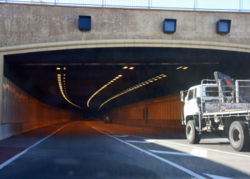
Perth has a road network with three freeways, nine metropolitan highways and no toll roads.
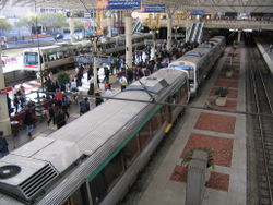
Perth metropolitan public transport, including trains, buses and ferries, are provided by Transperth, with links to rural areas provided by Transwa. There are 59 railway stations and 15 bus stations in the metropolitan area.
The Government of Western Australia has significantly increased metropolitan public transport funding in recent years. Initiatives include progressive replacement of the bus fleet and the SmartRider contactless smartcard ticketing system. Additionally, the rail network has been expanded in the northern and southern suburbs as part of the New MetroRail project.
The Indian Pacific passenger rail service connects Perth with Adelaide and Sydney via Kalgoorlie. The Transwa Prospector passenger rail service connects Perth with Kalgoorlie via several wheatbelt towns.
Rail freight terminates at the Kewdale Rail Terminal, 15 kilometres south-east of the city centre.
Perth's main container and passenger port is at Fremantle, 19 kilometres south west at the mouth of the Swan River . A second port complex is being developed in Cockburn Sound primarily for the export of bulk commodities.
