Missouri River
2007 Schools Wikipedia Selection. Related subjects: North American Geography
| Missouri River | |
|---|---|
|
|
|
| Origin | Confluence of Madison, Gallatin and Jefferson in Montana. |
| Mouth | Mississippi River at St. Charles, Missouri |
| Basin countries | USA, Canada |
| Length | 2,341 miles (3,767 km) |
| Avg. discharge | ~35,000 cubic feet/sec (1,050 m³/sec) |
| Basin area | 529,300 square miles (1,376,180 km²) |
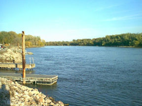
The Missouri River is a tributary of the Mississippi River in the United States. The Missouri begins at the confluence of the Madison, Jefferson, and Gallatin rivers in Montana, and flows into the Mississippi north of St. Louis, Missouri. At 2,341 mi (3,767 km) in length, it drains approximately one-sixth of the North American continent. Depending on whether its length is reckoned from the headwaters of its sources (as the Mississippi's length is reckoned from Lake Itasca, Minnesota), or from their confluence where the Missouri is first so-named (at Three Forks, Montana), it is currently either the longest or second-longest river in the United States. Prior to the Pick-Sloan Program and channelization, it was unquestionably the longest river in the US. The combined Missouri-Mississippi river system is the third longest river in the world. According to statements from the Army Corps of Engineers, in an average year, the Missouri River provides about 45 percent of the flow of the Mississippi past St. Louis. The mean flow of the Missouri at its mouth is approximately 35,000 cfs, compared to 47,000 cfs of the Mississippi below the Illinois River, which joins about 17 miles north of the confluence (ref.?). Its volume on average is also less than that of the Ohio River, another tributary of the Mississippi.
Course
The headwaters of the Missouri are in the Rocky Mountains of southwestern Montana, near the Continental Divide. The river rises in the Jefferson, Madison, and Gallatin rivers, which converge near Three Forks, Montana to form the Missouri. It flows north, through mountainous canyons, emerging from the mountains near Great Falls, where a large cataract historically marked the navigable limit of the river. It flows east across the plains of Montana into North Dakota, then turns southeast, flowing into South Dakota, and along the north and eastern edge of Nebraska, forming part of its border with South Dakota and all of its border with Iowa, flowing past Sioux City and Omaha. It forms the entire boundary between Nebraska and Missouri, and part of the boundary between Missouri and Kansas. At Kansas City, it turns generally eastward, flowing across Missouri where it joins the Mississippi just north of St. Louis.
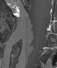
The river is nicknamed "Big Muddy" and also "Dark River" because of the high silt content in its flow, a feature that is highly visible at its confluence with the Mississippi. The river was of great importance in the United States' westward expansion. During the 18th century, the river was used by fur traders under the flags of Spain and France. The entire Missouri River watershed was acquired from the French by the United States in 1803 as part of the Louisiana Purchase and explored by the Lewis and Clark Expedition, which successfully used the river in exploring for a route to the Pacific Ocean. During the middle and late-19th century, the river was a primary means of transportation for goods and passengers before the spread of the railroads. The extensive use of paddle steamers on the upper river helped facilitate European settlement of the Dakotas and Montana, serving to spark several of the most intense Indian Wars in the region.
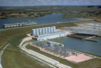
In the 20th century, the upper Missouri was extensively dammed for flood control, irrigation, and hydroelectric power. After President Franklin D. Roosevelt signed the Flood Control Act of 1944, the Pick-Sloan Plan turned the Missouri River into the largest reservoir system in North America. There are six dams in four states: Fort Peck in Montana; Garrison in North Dakota; Oahe, Big Bend, and Fort Randall in South Dakota, and Gavins Point on the South Dakota-Nebraska border.
These dams were constructed without locks, so commercial navigation on the Missouri cannot proceed above the Gavins Point Dam. The Corps of Engineers maintains a 9-foot deep (3 meter) navigation channel for 735 miles (1183 km) between Sioux City, Iowa and St. Louis. The dams aid navigation on the lower river by reducing fluctuations in water levels.
The only significant stretch of free-flowing stream on the lower Missouri is the Missouri National Recreational River section between Gavins Point Dam and Ponca State Park, Nebraska. This federally-designated " Wild and Scenic River" is among the last unspoiled stretches of the Missouri, and exhibits the islands, bars, chutes and snags that once characterized the "Mighty Mo".
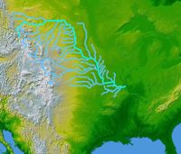
The extensive system of tributaries drain nearly all the semi-arid northern Great Plains of the United States. A very small portion of southern Alberta, Canada is also drained by the river through its tributary, the Milk.
The river's course roughly follows the edge of the glaciation during the last ice age. Most of the river's longer tributaries stretch away from this edge, with their origins towards the west, draining portions of the eastern Rockies.
Popular depictions
The American painter George Catlin traveled up the Missouri in the 1830s, making portraits of individuals and tribes of Native Americans. He also painted several Missouri River landscapes, notably " Floyd's Bluff" and " Brick Kilns", both from 1832.
The Swiss painter Karl Bodmer accompanied German explorer Prince Maximilian zu Wied-Neuwied from 1832 through 1834 on his Missouri River expedition. Bodmer was hired as an artist by Maximilian for the purpose of recording images of the Native American tribes that they encountered in the American West.
In 1843, the American painter and naturalist John James Audubon traveled west to the upper Missouri River and the Dakota Territory to do fieldwork for his final major opus, Viviparous Quadrupeds of North America. A typical example from this folio is "American Bison".
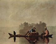
Missouri painter George Caleb Bingham immortalized the fur traders and flatboatmen who plied the Missouri River in the early 1800s; these same boatmen were known for their river chanties, including the haunting American folk song " Oh Shenandoah". Each verse of " Oh Shenandoah" ends with the line, "...'cross the wide Missouri."
The river is notable for being the setting of the Pete Seeger song Waist Deep in the Big Muddy. (There is some ambiguity as to location. Seeger also sings that the action took place in "Loo-siana".) The song is set in 1942, during training for World War II, but its image of a foolish captain who pushes his men further and further into a hopeless situation was clearly meant to parallel the Vietnam War. In the song, a captain leading a squad on training maneuvers insists on crossing the titular river, insisting that it is safe to cross. The captain sinks into the mud, drowns, and his squad turns back. As they are heading back, they are taken by the beauty of the river and stay.
Tributaries
Montana
- Jefferson River
- Madison River
- Gallatin River
- Sixteenmile Creek
- Dearborn River
- Smith River
- Sun River
- Belt Creek
- Marias River
- Arrow Creek
- Judith River
- Cow Creek
- Musselshell River
- Milk River
- Redwater River
- Poplar River
- Big Muddy Creek
North Dakota
- Yellowstone River
- Little Muddy Creek
- Tobacco Garden Creek
- Little Missouri River
- Knife River
- Heart River
- Cannonball River
South Dakota
- Grand River
- Moreau River
- Cheyenne River
- Bad River
- White River
- James River
- Vermillion River
- Big Sioux River (Iowa border)
Nebraska, Iowa, Kansas, Missouri
- Niobrara River (Nebraska)
- Platte River (Nebraska)
- Little Nemaha River (Nebraska)
- Big Nemaha River (Nebraska)
- Perry Creek (Iowa)
- Floyd River (Iowa)
- Little Sioux River (Iowa)
- Soldier River (Iowa)
- Boyer River (Iowa)
- Mosquito Creek (Iowa)
- Nishnabotna River (Iowa)
- Kansas River (Kansas)
- Blue River (Kansas, Missouri)
- Osage River (Missouri)
- Platte River, Missouri (Missouri)
Major cities along the river
For a full list, see List of cities and towns along the Missouri River
- Great Falls, Montana
- Bismarck, North Dakota (capital)
- Pierre, South Dakota (capital)
- Sioux City, Iowa
- Council Bluffs, Iowa
- Omaha, Nebraska
- Saint Joseph, Missouri
- Kansas City, Kansas
- Kansas City, Missouri
- Jefferson City, Missouri (capital)
- Saint Charles, Missouri
