Levee failures in Greater New Orleans, 2005
2007 Schools Wikipedia Selection. Related subjects: Natural Disasters; Recent History
| Hurricane Katrina |
|
 |
|
|
General
Impact
Relief
Analysis
Other wikis
|
|
In 2005, as a result of Hurricane Katrina, there were extensive failures of the levees and flood walls protecting New Orleans, Louisiana and surrounding communities. There were also extensive subsequent investigations by civil engineers to attempt to identify the underlying reasons for the failures.
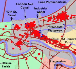
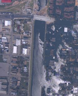
The Mississippi River Gulf Outlet ("MR-GO") breached its levees in approximately 20 places, flooding much of New Orleans East, most of Saint Bernard Parish and the East Bank of Plaquemines Parish. The major levee breaches in the city included breaches at the 17th Street Canal levee, the London Avenue Canal, and the wide, navigable Industrial Canal, which left approximately 80% of the city flooded. There were three major breaches at the Industrial Canal; one on the upper side near the junction with MR-GO, and two on the lower side along the Lower Ninth Ward, between Florida Avenue and Claiborne Avenue. The 17th Street Canal levee was breached on the lower (New Orleans West End) side inland from the Old Hammond Highway Bridge, and the London Avenue Canal breached in two places, on the upper side just back from Robert E. Lee Boulevard, and on the lower side a block in from the Mirabeau Avenue Bridge. Flooding from the breaches put the majority of the city under water for days, in many places for weeks.
In the aftermath of Hurricane Katrina, engineers investigated the possibility that a failure in the design, construction, or maintenance caused much of the flooding. Some investigations point to the possibility of a weakening of the soil beneath the foundations of the flood walls due to storm water, which would indicate that a major design flaw made during the construction of the levees had been a major cause of the failures due to the storm.
Background
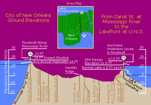
Flooding due to rain and storms has long been an issue since the New Orleans' early settlement due to the city's location on a delta marsh, much of which sits below sea level. The city is surrounded by the Mississippi River to the south, Lake Pontchartrain to the north, and Lake Borgne to the east. Construction of the levees along the River began soon after the city was founded, and more extensive river levees were built as the city grew. The levees were originally designed to prevent damage caused by seasonal flooding. Today, the modern 17th Street and London Avenue Canals are used for drainage, while the wide, navigable Industrial Canal is used for shipping. The heavy flooding caused by Hurricane Betsy in 1965 brought concerns regarding flooding from hurricanes to the forefront.
Shortly after hurricane Betsy, the Army Corps of Engineers designed a Lake Pontchartrain Hurricane Barrier to shield the city with flood gates like those that protect the Netherlands from the North Sea. Congress provided funding and construction began in 1971, but work stopped in 1977 when a federal judge ruled, in a suit brought by Save Our Wetlands, that the Corps' environmental impact statement was deficient. In 1985, after nearly a decade of court battles, the Corps scrapped the plan, and decided on reinforcing the city’s levee system instead.
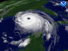
There were many predictions of hurricane risk in New Orleans before Hurricane Katrina in August, 2005. In 2001, the Houston Chronicle published a story which predicted that a severe hurricane striking New Orleans, "would strand 250,000 people or more, and probably kill one of 10 left behind as the city drowned under 20 feet of water. Thousands of refugees could land in Houston." Many concerns also focused around the fact that the city's levee system was only designed for hurricanes of no greater intensity than category 3. As it turned out, Katrina was Category 3 when it made landfall and most of New Orleans experienced Category 1 or 2 strength winds. However, due to the slow moving nature of the storm in its pass over New Orleans, several floodwalls lining the shipping and drainage canals in New Orleans collapsed and the resulting flood water from Lake Ponchartrain inundated the city within the two days following the storm, causing costly damage to buildings and resulting in many deaths.
Furthermore, the region's natural defenses, the surrounding marshland and the barrier islands, have been dwindling in recent years.
Levee and floodwall breaches
Most of the levee failures were reported on Monday, August 29, 2005, at various times throughout the day. Overall, approximately 28 levee failures were reported. A breach in the Industrial Canal, near the St. Bernard/ Orleans parish line, occurred at approximately 9:00 AM CST, the day Katrina hit. Another breach in the Industrial Canal was reported a few minutes later at Tennessee Street, as well as multiple failures in the levee system, as well as a pump failure, in the Lower Ninth Ward, near Florida Avenue.
Local fire officials reported a breach at the 17th Street Canal levee at about 12:00 PM CST, though there was some confusion among FEMA officials over whether this was an actual breach, or overtopping. The Duncan and Bonnabel Pumping Stations were also reported to have taken roof damage, and were non-functional.
Breaches at St. Bernard and the Lower Ninth Ward were reported at 5:00 PM CST, as well as a breach at the Haynes Blvd. Pumping Station, and another breach along the 17th Street Canal levee.
By 8:30 PM CST, all pumping stations in Jefferson and Orleans parishes were reported as non-functional.
At 10:00 PM CST, a breach of the levee on the west bank of the Industrial Canal was reported, bringing 10 feet of standing water to the area.
A quarter-mile breach in the levee near the 17th Street Canal, 200 yards from Lake Pontchartrain, was reported at 10:30 PM CST. An estimated 66% to 75% of the city was now under water.
At about midnight, a breach in the London Avenue Canal levee was reported.
Interestingly enough, the Orleans Canal, about midway between the 17th Street Canal and the London Avenue Canal, supposedly engineered to the same standards, and presumably put under similar stress during the Hurricane, survived intact. An incomplete section of floodwall along this canal allowed water to overtopped at this point, thus reduced the pressure against the wall.
Investigations
Preliminary investigations
During the 6 weeks following Katrina, preliminary investigations were carried out by the Army Corps of Engineers, the American Society of Civil Engineers, as well as by independent parties.
Possible failure mechanisms being investigated by engineers included the overtopping of levees and floodwalls by the storm surge, consequential undermining of flood wall foundations or other weakening by water of the wall foundations, the storm surge pressures exceeding the strength of the floodwalls, as well as impact by vessels such as barges which had broken free of their moorings (such as the ING 4727 barge which may have crashed through a levee in the Industrial Canal near the Lower Ninth Ward).
A preliminary report by the American Society of Civil Engineers on an independent investigation has concluded that the flooding in the Lakeview neighbourhood was caused by the soil of the levees giving way and not by water overtopping the flood walls. The statement said that there was evidence that a section of the levee embankment that supported the flood wall had moved approximately 45 feet laterally. Inspectors also found evidence of the dirt levee moving at the London Avenue breach. However, many miles of levees worked as they should even though the water got over their tops.
Soil borings have been made in the area of the 17th Street Canal breach. These borings show a layer of peat which starts about 15 to 30 feet below the surface and ranges from about 5 feet to 20 feet thick. The peat is from the remains of the swamp on which the low area of New Orleans (near Lake Ponchartrain) were built. The shear strength of this peat was found to be very low, and to have a high water content. According to Prof. Robert Bea, a geotechnical engineer from the University of California, Berkeley, this would make the floodwall very vulnerable to the stresses of a large flood. "At 17th Street, the soil moved laterally, pushing entire wall sections with it. ... As Katrina's storm surge filled the canal, water pressure rose in the soil underneath the wall and in the peat layer. Water moved through the soil underneath the base of the wall. When the rising pressure and moving water overcame the soil's strength, it suddenly shifted, taking surrounding material -- and the wall -- with it."
The peat layer appears to be about 1000 feet wide. It is not clear if it was properly taken into account when the levees were built. The flood walls consist of a concrete cap on a sheet pile base driven 17.5 feet deep at 17th Street Canal. A deeper piling would have anchored the flood wall in much stronger soil.
Floodwall design
Investigators are focusing on the 17th Street and London Avenue canals because evidence shows they were breached even though water did not flow over their tops. That could indicate a design or construction flaw. Eyewitness accounts and other evidence shows that levees and flood walls in other parts of the city, such as along the Industrial Canal, were topped by floodwaters first, then breached or eroded. Many of the New Orleans levee and floodwall failures in the wake of Hurricane Katrina occurred at weak-link junctions where different levee or wall sections joined together, according to a preliminary report released on November 2, 2005, by independent investigators from the University of California, Berkeley, and the American Society of Civil Engineers (ASCE).
In the investigation by the American Society of Civil Engineers, it was found that when the geological borings were made in 1981 prior to construction of floodwalls along the 17th Street Canal, they revealed to both the Army Corps of Engineers officials as well as the contractors who designed and built the wall the nature of the weak layer of soft soil that would lie under the base of flood walls' foundation of steel piling.
"According to the analysis, they've got the soil strength test. It doesn't show exactly the input for the analysis, but assuming they used it and came out with factors of safety, it's showing the numbers are safe. So it leaves an open-ended question as to why the flood wall failed." said Peter Nicholson, a geotechnical engineer from the University of Hawaii who is heading up an American Society of Civil Engineers team looking at the levees.
The original design for the steel sheet foundations for the flood walls showed a proposed depth of 10 feet (3 meters), and the design documents show calculations were made with the wall base at 12.8 feet (3.9 meters). According to a New Orleans engineer, the depth was apparently increased later, to a depth of 17 feet (5.1 meters), and this is what was built. However, investigations using sonar by a forensic engineering team from the Louisiana State University showed that at one point near the 17th Street Canal breach, the piling extends just 10 feet (3 meters) below sea level, 7 feet (2.1 meters) shorter than the Corps of Engineers had maintained. "The corps keeps saying the piles were 17 feet, but their own drawings show them to be 10," van Heerden said. "This is the first time anyone has been able to get a firm fix on what's really down there. And, so far, it's just 10 feet. Not nearly deep enough." Other reports confirmed that construction on the London Avenue and Industrial Canal levees was similarly below these stated standards. They also found evidence that homeowners along the 17th Street Canal near what would be the site of the breach had been reporting on persistent seepage from the canal flooding their yards for a year prior to Hurricane Katrina. Other studies showed that the levee floodwalls on the 17th Street Canal were, "destined to fail,", from bad Army Corps of Engineers design, saying in part, "that miscalculation was so obvious and fundamental," investigators said, they, "could not fathom how the design team of engineers from the corps, local firm Eustis Engineering and the national firm Modjeski and Masters could have missed what is being termed the costliest engineering mistake in American history."
It is likely that the Katrina storm surge created unusual subterranean pressures under the walls. Those pressures appear to have made soil under the sheet pile weaker so that it gave way, moving the steel sheet-pile-and-concrete walls along with it. But engineers studying the levees also say that other, unknown factors, including structural problems in the walls, could also have contributed to the breaches.
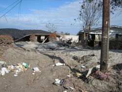
Aerial evaluation revealed damage to approximately 90% of some of the levee systems in the east which should have protected St. Bernard Parish.
Levee maintenance
Poor maintenance practices were also found along miles of other levees. A possible trigger of the 17th Street Canal levee breach may have been the fall of a large oak tree, planted too close to the base of the levee. A similar scenario may have played out on the London Avenue Canal. Burrowing animals created large tunnels that undermined already weak foundations. Maintenance and inspection are the responsibility of local levee boards.
National Academy of Sciences Investigation
On October 19, 2005, Defense Secretary Donald Rumsfeld announced that an independent panel of experts, under the direction of the National Academy of Sciences, would convene to evaluate the performance of the New Orleans levee system, and issue a final report in eight months. The panel would study the results provided by the two existing teams of experts that have already examined the levee failures.
Senate Committee hearings
Preliminary investigations and evidence were presented before the U.S. Senate Committee on Homeland Security and Governmental Affairs on November 2, 2005, and generally confirm the preliminary investigations described above.
In his written evidence to the committee, Ivor van Heerden, from Louisiana State University, concluded, "Most of the flooding of New Orleans was due to man’s follies. Society owes those who lost their lives, and the approximately 100,000 families who lost all, an apology and needs to step up to the plate and rebuild their homes, and compensate for their lost means of employment. New Orleans is one of our nations jeweled cities. Not to have given the residents the security of proper levees is inexcusable."
U.S. Army Corps of Engineers Admits Fault
On April 5, 2006, months after independent investigators had demonstrated that levee failures were not due to natural forces beyond intended design strength, Lt. Gen. Carl Strock testified before the U. S. Senate Subcommittee on Energy and Water that, "We have now concluded we had problems with the design of the structure." He also testified that the U.S. Army Corps of Engineers did not know of this mechanism of failure prior to August 29, 2005. The claim of ignorance is refuted, however, by the National Science Foundation investigators hired by the Army Corps of Engineers, who point to a 1986 study by the Corps itself that such separations were possible in the I-wall design.
Nearly two months later, June 1, 2006, the US ACE finally unequivicaolly admitted responsbility for the tragedy in New Orleans with the release of the completed report. The Final Draft of the IPET report states that the destructive forces of Katrina were not contained by but were "aided by incomplete protection, lower than authorized structures, and levee sections with erodible materials."
