Image:Wpdms nasa topo merrimack river.jpg
From Wikipedia, the free encyclopedia
Wpdms_nasa_topo_merrimack_river.jpg (337 × 359 pixel, file size: 18 KB, MIME type: image/jpeg)
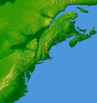
The Merrimack River is shown on a map of the northeastern United States.
Based on original public domain image courtesy of NASA.
© 2004 Matthew Trump.

Permission is granted to copy, distribute and/or modify this document under the terms of the GNU Free Documentation License, Version 1.2 or any later version published by the Free Software Foundation; with no Invariant Sections, no Front-Cover Texts, and no Back-Cover Texts.
Subject to disclaimers.
File history
Legend: (cur) = this is the current file, (del) = delete this old version, (rev) = revert to this old version.
Click on date to download the file or see the image uploaded on that date.
- (del) (cur) 23:25, 1 March 2004 . . Decumanus ( Talk | contribs) . . 337×359 (18,812 bytes) (Merrimack River)
-
Edit this file using an external application
See the setup instructions for more information.
File links
Category: GFDL images