Merrimack River
2007 Schools Wikipedia Selection. Related subjects: North American Geography
| Merrimack River | |
|---|---|
|
|
|
| Origin | Franklin, New Hampshire |
| Mouth | Atlantic Ocean |
| Basin countries | USA |
| Length | 110 miles (177 km) |
| Source elevation | n/a |
| Avg. discharge | 7,562 ft3/s |
| Basin area | Approx. 5,000 square miles (13,000 km²) |
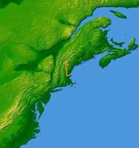
The Merrimack River (or Merrimac River, an earlier spelling that is sometimes still used) is a 110-mile-long (177-kilometer-long) river in the Northeastern United States. It rises at the confluence of the Pemigewasset and Winnipesaukee rivers in Franklin, New Hampshire, flows southward into Massachusetts, and then flows northeast, near the Massachusetts-New Hampshire border, until it empties into the Atlantic Ocean at Newburyport.
Several U.S. naval ships have been named the USS Merrimack and USS Merrimac in honour of this river.
History and details
Prior to glaciation, the Merrimack continued its southward course far beyond the present day New Hampshire-Massachusetts border to enter the Atlantic Ocean near Boston. Upon the glacier's retreat, debris deposited north of Boston filled the lower Merrimack Valley, redirecting the river into its current northeast bend at Lowell.
The total watershed of the river is approximately 5,000 square miles (13,000 km²), covering much of southern New Hampshire and a portion of northeastern Massachusetts. On its banks are a number of cities built to take advantage of water power in the 19th-century, when textile mills dominated the New England economy: Concord, Manchester, and Nashua in New Hampshire, and Lowell, Lawrence, and Haverhill in Massachusetts. At the mouth of the river is the small city of Newburyport. Prior to the construction of the Middlesex Canal, Newburyport was an important ship-building city, since it was in a location to receive New Hampshire timber that had been floated downriver.
The river is perhaps best known for the early American literary classic A Week on the Concord and Merrimack River by Henry David Thoreau. Among its tributaries are the Souhegan River, which extends west from the town of Merrimack, New Hampshire, the Nashua River, which flows north into the city of Nashua, the Concord River, which flows north from Concord, Massachusetts to Lowell, and the Shawsheen River, which after also flowing north, joins the Merrimack at Lawrence.
Etymology
The name Merrimack is believed to have been adopted by early European settlers from Merruasquamack, a name meaning "swift water place" that given by Native American tribes for the portion of the river between Manchester, New Hampshire and Lowell, Massachusetts. A number of tribes occupied the watershed and gave the river several different names.
The original Euro-American spelling of the river's name was Merrimac, but the river is now named Merrimack. Both variants were used in early days and can continue to be seen in the present day in the names of two New England towns. Merrimac, Massachusetts, settled in 1638 and originally part of Amesbury, Massachusetts, was called West Amesbury until 1876, at which time it adopted its current name and spelling. Merrimack, New Hampshire was incorporated in 1746, spelling its name "Marrymac" in the record of its first town meeting. It is referred to as Merrimac into the early 19th century: in the 1810 decennial census, it was spelled Merrimac, but in the 1820 and afterwards, Merrimack. When, where and why the names of this town and the river became standardized as Merrimack is unknown.
May 2006 Flooding
While the Merrimack River is prone to minor flooding, on May 15, 2006 rainfall raised the river more than 8 feet above flood stage, forcing evacuations, damaging property, and breaking the main sewage pipeline in the city of Haverhill, Massachusetts, dumping 35 million gallons of raw sewage waste into the river per day. Reports of total rainfall vary, but most areas appear to have received around a foot of rain with some areas receiving as much as 17 inches.
According to The Boston Globe, around 1,500 people evacuated their homes to escape the flood.
This flood also prompted the city of Lowell, Massachusetts to drop the flood-controlling Francis Gate for only the third time in its 150 years of service. When lowered, the Francis gate seals the city's canal system off from its source on the Merrimack. The Great Gate, as it is also called, was built in 1850 under the direction of James B. Francis. Considered unnecessary when it was first constructed, "Francis' Folly" saved the centre of Lowell from overflowing canals in 1852 and 1936. However, technically, the gate was not dropped in 2006 since a more modern bulkhead of 16 inch by 16 inch steel beams constructed against the side of the Francis Gatehouse was used instead.
The most significant flood in the recorded history of the Merrimack was in March of 1936, when a double flood of rain and melting snow and ice swelled the Merrimack to 68.4 feet, 10 feet higher than the 2006 flood. The Jack Kerouac book Doctor Sax is set during this event.


