Image:Vesta elevation HST1996.jpg
From Wikipedia, the free encyclopedia
Vesta_elevation_HST1996.jpg (250 × 250 pixel, file size: 23 KB, MIME type: image/jpeg)
Summary
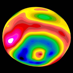
Globe of 4 Vesta showing elevation, viewed from the south-east, with the south pole crater and its central peak prominent. Elevation data were compiled from Hubble Space Telescope images taken in May 1996, from a distance of 177 Gm with a resolution of about 36 km per pixel. Red denotes high elevation, blue low. Scale as shown in Image:Vesta_elevation_map_HST1996.jpg.
Image taken from http://hubblesite.org/newscenter/newsdesk/archive/releases/1997/27/image/e and manually reduced from maximum resolution version.
Licensing
 |
This file is in the public domain because it was created by NASA. NASA copyright policy states that "NASA material is not protected by copyright unless noted". ( NASA copyright policy page or JPL Image Use Policy). Warnings:
|
|
File history
Legend: (cur) = this is the current file, (del) = delete this old version, (rev) = revert to this old version.
Click on date to download the file or see the image uploaded on that date.
- (del) (cur) 21:44, 12 November 2005 . . Deuar ( Talk | contribs) . . 250×250 (24,002 bytes) (http://hubblesite.org/newscenter/newsdesk/archive/releases/1997/27/image/e (Hubble Space Telescope image, NASA))
-
Edit this file using an external application
See the setup instructions for more information.
File links
Category: NASA images