Image:Vesta elevation map HST1996.jpg
From Wikipedia, the free encyclopedia

No higher resolution available.
Vesta_elevation_map_HST1996.jpg (400 × 282 pixel, file size: 35 KB, MIME type: image/jpeg)
Summary
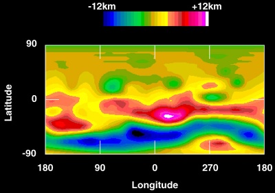
Topographic map of 4 Vesta showing elevation. Elevation data were compiled from Hubble Space Telescope images from a distance of 177 Gm, taken in May 1996 with a resolution of about 36 km per pixel.
Image taken from http://hubblesite.org/newscenter/newsdesk/archive/releases/1997/27/image/b and manually reduced from maximum resolution version.
Licensing
 |
This file is in the public domain because it was created by NASA. NASA copyright policy states that "NASA material is not protected by copyright unless noted". ( NASA copyright policy page or JPL Image Use Policy). Warnings:
|
|
File history
Legend: (cur) = this is the current file, (del) = delete this old version, (rev) = revert to this old version.
Click on date to download the file or see the image uploaded on that date.
- (del) (cur) 21:45, 12 November 2005 . . Deuar ( Talk | contribs) . . 400×282 (35,942 bytes) (http://hubblesite.org/newscenter/newsdesk/archive/releases/1997/27/image/b (Hubble Space Telescope image, NASA))
-
Edit this file using an external application
See the setup instructions for more information.
File links
The following pages on the English Wikipedia link to this file (pages on other projects are not listed):
Category: NASA images