Tropical Storm Lee (2005)
2007 Schools Wikipedia Selection. Related subjects: Storms
| Tropical storm ( SSHS) | ||
|---|---|---|
|
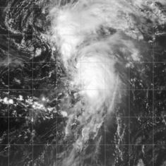
Lee on August 31, 2005 |
||
| Formed | August 28, 2005 | |
| Dissipated | September 2, 2005 | |
| Highest winds |
|
|
| Lowest pressure | 1006 mbar ( hPa) | |
| Damage | None reported | |
| Fatalities | None reported | |
| Areas affected |
No land areas | |
| Part of the 2005 Atlantic hurricane season |
||
Tropical Storm Lee was a weak storm in the 2005 Atlantic hurricane season that briefly reached tropical storm strength late in August over the central Atlantic. It was the twelfth named storm of the season and spent much of its lifespan as a tropical depression or as a remnant low.
Tropical Storm Lee initially formed east of the Lesser Antilles as a tropical depression on August 28, before degenerating into a remnant low the next day. The low moved north and briefly achieved tropical storm status on August 31, as it moved around a non-tropical system, the presence of which complicated forecasts. Tropical Storm Lee degenerated back into a remnant low on September 2 and was then absorbed by a cold front. During its brief existence Tropical Storm Lee never threatened any land.
Storm history
A tropical wave moved off the coast of Africa on August 24. It developed into an area of low pressure area as it crossed the Atlantic, and organized into Tropical Depression Thirteen on August 28 while 960 mi (1550 km) east of the Lesser Antilles. Because of northeasterly shear, the centre of the circulation was removed from the convection, and the depression degenerated into a remnant low late on August 29. Many of the models had indicated that this was likely, but the National Hurricane Centre (NHC) instead chose to forecast slight strengthening.
The remnant low moved northwards, then turned to the northeast due to the effects of a non-tropical system. As it moved to the northeast, the activity in the remnant low increased again and the depression regenerated on August 31. That afternoon, the depression strengthened further into Tropical Storm Lee, reaching its peak intensity with winds of 40 mph (65 km/h), in between Bermuda and the Azores. As quoted by NHC forecaster Dr. Lixion Avila, "There is an uncertainty in the intensity of the tropical cyclone at this time". This uncertainty was shown by the NHC operationally downgrading the storm to a depression after just 6 hours, when in post-season analysis it was found to have lasted twice as long. Lee weakened again into a tropical depression as it continued to move around the non-tropical low to its west. The presence of this low made Lee difficult to forecast, and as the two systems began to merge on September 1, it resulted in uncertainty relating to what degree the system remained tropical. Later that day, shear again removed the convection of the depression, and Lee became a remnant low which survived until September 4 when it was absorbed by a cold front.
Impact
Tropical Storm Lee did not affect any land areas and there were no reports of damage or fatalities. Because Lee stayed well out to sea, no warnings or watches were issued.
Naming and records
When Tropical Storm Lee was formed on August 31, it was the second earliest occurrence in a season for the development of the 12th named tropical storm, 2 days after the record held by Hurricane Luis of the 1995 season. This made it one of the few storms of the 2005 Atlantic hurricane season to not hold a record for the earliest formation of the nth storm. Additionally, while this was the first use of Lee to name an Atlantic storm, following the retirement of Hurricane Lenny in 1999, Lee had previously been used to name 3 storms in the Western Pacific Ocean. Due to the lack of any effects from Tropical Storm Lee, the name was not retired by the World Meteorological Organization and will be on the list of names for the 2011 Atlantic hurricane season.

