Roman road
2007 Schools Wikipedia Selection. Related subjects: British History 1500 and before (including Roman Britain)
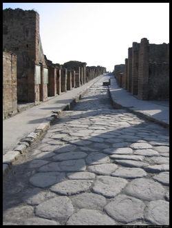
The Roman roads were essential for the growth of the Roman empire, by enabling the Romans to move armies. A proverb says that "all roads lead to Rome." Roman roads were designed that way to hinder provinces organising resistance against the Empire. At its peak, the Roman road system spanned 53,000 miles (85,300 km) and contained about 372 links.
The Romans, for military, commercial and political reasons, became adept at constructing roads, which they called viae (plural of the singular term via). The word is related to the English way and weigh, as in 'to weigh anchor'. The Indo-European root, *wegh-, with a palatal g, becomes *wegh- with a guttural g in the centum languages, including Latin. It means "to go" with the sense of transporting in a vehicle. Viae were always intended primarily as carriage roads, the means of carrying material from one location to another.
These long highways were very important in maintaining both the stability and expansion of the empire. The legions made good time on them, and some are still used millennia later. In late Antiquity these roads played an important part in Roman military reverses by offering avenues of invasion to the barbarians.
The Roman road system
Types of roads
Roman roads vary from simple corduroy roads to paved roads using deep roadbeds of tamped rubble as an underlying layer to ensure that they kept dry, as the water would flow out from between the stones and fragments of rubble, instead of becoming mud in clay soils.
The laws of the Twelve Tables, dated to approximately 450 BC, specify that a road shall be 8 feet wide where straight and 16 where curved. The tables command Romans to build roads and give wayfarers the right to pass over private land where the road is in disrepair. Building roads that would not need frequent repair therefore became an ideological objective.
Roman law defined the right to use a road as a servitus, or claim. The jus eundi ("right of going") established a claim to use an iter, or footpath, across private land; the ius agendi ("right of driving"), an actus, or carriage track. A via combined both types of servitutes, provided it was of the proper width, which was determined by an arbiter. The default width was the latitudo legitima of 8 feet. In these rather dry laws we can see the prevalence of the public domain over the private, which characterized the republic.
With the conquest of Italy prepared viae were extended from Rome and its vicinity to outlying municipalities, sometimes overlying earlier roads. Building viae was a military responsibility and thus came under the jurisdiction of a consul. The process had a military name, viam munire, as though the via were a fortification. Municipalities, however, were responsible for their own roads, which the Romans called viae vicinales.
A via connected two cities. Some links in the network were as long as 55 miles. The builders always aimed at a regulation width, but actual widths have been measured at between 3' 9" and 24'.
The builders aimed at directional straightness. Many long sections are ruler-straight, but it should not be thought that all of them were. The Roman emphasis on constructing straight roads often resulted in steep grades relatively impractical for most economic traffic; over the years the Romans themselves realized this and built longer, but more manageable, alternatives to existing roads.
Viae were generally centrally placed in the countryside. Features off the via were connected to the via by viae rusticae, or secondary roads. Either main or secondary roads might be paved, or they might be left unpaved, with a gravel surface, as they were in North Africa. These prepared but unpaved roads were viae glareae or sternendae ("to be strewn"). Beyond the secondary roads were the viae terrenae, "dirt roads". A road map of the empire reveals that it was laced fairly completely with a network of prepared viae. Beyond the borders are no roads; however, one might presume that footpaths and dirt roads allowed some transport.
Traveling a road
Milestones
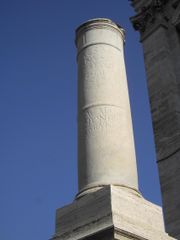
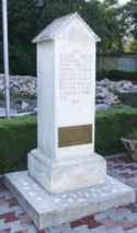
Before 250 BC, the via Appia, and after 124 BC, most viae, were divided into numbered miles by milestones. The words we translate as mile are milia passuum, "one thousand of paces", which amounted to about 1620 yards, 1480 meters. A milestone, or miliarium, was a circular column on a solid rectangular base, set two feet into the ground, standing several feet high, 20" in diameter, weighing about 2 tons. At the base was inscribed the number of the mile relative to the road it was on. In a panel at eye-height was the distance to the Roman Forum and various other information about the officials who made or repaired the road and when. These miliaria are valuable historical documents now. Their inscriptions are collected in the volume XVII of the Corpus Inscriptionum Latinarum.
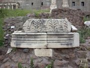
The Romans had a preference for standardization whenever they could, and so Augustus, after becoming permanent commissioner of roads in 20 BC, set up the miliarium aureum (golden milestone) near the temple of Saturn. All roads were considered to begin from this gilded bronze monument. On it were listed all the major cities in the empire and distances to them. Constantine called it the umbilicus Romae (navel of Rome).
Milestones permitted distances and locations to be known and recorded exactly. It wasn't long before historians began to refer to the milestone at which an event occurred.
Way stations
A legion on the march didn't need a way station, as it brought its own baggage train (impedimenta) and constructed its own camp (castra) every evening at the side of the road. Other officials or people on official business, however, had no legion at their service, and so the government maintained way stations, or mansiones ("staying places"), for their use. Passports were required for identification.
Carts could travel about 8 miles per day, pedestrians a little more, and so each mansio was about 15 to 18 miles from the next one. There the official traveller found a complete villa dedicated to his refreshment. Often a permanent military camp or a town grew up around the mansio.
Non-official travellers needed refreshment too, and at the same locations along the road. A private system of 'inns' or cauponae were placed near the mansiones. They performed the same functions but were somewhat disreputable, as they were frequented by thieves and prostitutes. Graffiti decorate the walls of the few whose ruins have been found.
Genteel travellers needed something better than cauponae. In the early days of the viae, when little unofficial existed, houses placed near the road were required by law to offer hospitality on demand. Frequented houses no doubt became the first tabernae, which were hostels, rather than the "taverns" we know today. As Rome grew, so did its tabernae, becoming more luxurious and acquiring good or bad reputations as the case may be. One of the best hotels was the Tabernae Caediciae at Sinuessa on the Via Appia. It had a large storage room containing barrels of wine, cheese and ham. Many cities of today grew up around a taberna complex, such as Rheinzabern in the Rhineland, and Saverne in Alsace.
A third system of way stations serviced vehicles and animals: the mutationes ("changing stations"). They were located every 12-18 miles. In these complexes, the driver could purchase the services of wheelrights, cartwrights, and equarii medici, or veterinarians. Using these stations in chariot relays, the emperor Tiberius hastened 500 miles in 24 hours to join his brother, Drusus Germanicus, who was dying of gangrene as a result of a fall from a horse.
Vehicles
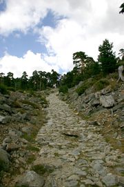
Roman law and tradition forbade the use of vehicles in urban areas, except in certain cases. Married women and government officials on business could ride. The Lex Iulia Municipalis restricted commercial carts to night-time access to the city within the walls and within a mile outside the walls. Outside the cities, Romans were avid riders and rode on or drove quite a number of vehicle types, some of which are mentioned here.
For purposes of description, Roman vehicles can be divided into the car, the coach and the cart. Cars were used to transport one or two individuals, coaches were used to transport parties, and carts to transport cargo.
Of the cars, the most popular was the carrus ("car"), a standard chariot form descending to the Romans from a greater antiquity. The top was open, the front closed. One survives in the Vatican. It carried a driver and a passenger. A carrus of two horses was a biga; of three horses, a triga; and of four horses a quadriga. The tires were of iron. When not in use, its wheels were removed for easier storage.
A more luxurious version, the carpentum, transported women and officials. It had an arched overhead covering of cloth and was drawn by mules. A lighter version, the cisium, equivalent to our gig, was open above and in front and had a seat. Drawn by one or two mules or horses, it was used for cab work, the cab drivers being called cisiani. The builder was a cisarius.
Of the coaches, the main stay was the raeda or reda, which had 4 wheels. The high sides formed a sort of box in which seats were placed, with a notch on each side for entry. It carried several people with baggage up to the legal limit of 1000 pounds. It was drawn by teams of oxen, horses or mules. A cloth top could be put on for weather, in which case it resembled a covered wagon.
The raeda was probably the main vehicle for travel on the roads. Raedae meritoriae were hired coaches. The fiscalis raeda was a government coach. The driver and the builder were both named a raedarius.
Of the carts, the main one was the plaustrum or plostrum. This was simply a platform of boards attached to wheels and a cross-tree. The wheels, or tympana, were solid and were several inches thick. The sides could be built up with boards or rails. A large wicker basket was sometimes placed on it. A two-wheel version existed. The 4-wheel type was the plaustrum maius.
The military used a standard wagon. Their transportation service was the cursus clabularis, after the standard wagon, called a carrus clabularius, clabularis, clavularis, or clabulare. It transported the impedimenta, or baggage of a military column.
Post offices
Two postal services were available under the empire, one public and one private.
The Cursus publicus, founded by Augustus, carried the mail of officials by relay throughout the Roman road system. The vehicle for carrying mail was a cisium with a box, but for special delivery, a horse and rider was faster. A relay of horses could carry a letter 500 miles in 24 hours. The postman wore a characteristic leather hat, the petanus. The postal service was a somewhat dangerous occupation, as postmen were a target for bandits and enemies of Rome.
Private mail of the well-to-do was carried by tabellarii, an organization of slaves available for a price.
The itinerary
The Romans and ancient travelers in general did not use maps. They may have existed as specialty items in some of the libraries, but they were hard to copy and were not in general use. On the Roman road system, however, the traveller needed some idea of where he was going , how to get there, and how long it would take. The itinerarium filled this need. In origin it was simply a list of cities along a road. It was only a short step from lists to a master list. To sort out the lists, the Romans drew diagrams of parallel lines showing the branches of the roads. Parts of these were copied and sold on the streets. The very best featured symbols for cities, way stations, water courses, and so on. They cannot be considered maps, as they did not represent landforms.
The Roman government from time to time undertook to produce a master itinerary of all Roman roads. Julius Caesar and Mark Antony commissioned the first known such effort in 44 BC. Zenodoxus, Theodotus and Polyclitus, three Greek geographers, were hired to survey the system and compile a master itinerary. This task required over 25 years. The result was a stone engraved master itinerarium set up near the Pantheon, from which travelers and itinerary sellers could make copies.
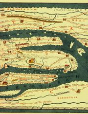
Another master itinerary, the Itinerarium Provinciarum Antonini Augusti (the Antonine Itinerary) is known to have been undertaken in 217 AD. It was first printed in 1521 and after many reprintings survives today. Another major surviving itinerary is the Tabula Peutingeriana. The Ravenna Cosmography dates from the 7th century, but repeats earlier material.
Archaeology has turned up some itinerary material in unexpected places. The Cups of Cadiz, four silver cups found by workmen excavating a foundation at Bracciano in 1852, are engraved with the names and distances of stations between Cadiz and Rome.
The term itinerary changed meaning over the centuries. In the Itinerarium Burdigalense (Bordeaux Pilgrim, 333 AD), the itinerary is a description of what route to take to the Holy Land. The Itinerarium Alexandri is a list of the conquests of Alexander the Great. Today it means either a travel journal or a list of recommended stops.
Construction of a road
The method
The Romans are believed to have inherited the art of road construction from the Etruscans. No doubt the art grew as it went along and also incorporated good ideas from other cultures.
After the architect looked over the site of the proposed road and determined roughly where it should go, the agrimensores went to work surveying the road bed. They used two main devices, the rod and one called the groma, which helped them obtain right angles. The gromatici, the Roman equivalent of rod men, placed rods and put down a line called the rigor. As they did not possess anything like a transit, an architect tried to achieve straightness by looking along the rods and commanding the gromatici to move them as required. Using the gromae they then laid out a grid on the plan of the road.
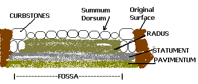
The libratores began their work. Using ploughs and legionaries with spades, they excavated the road bed down to bed rock or at least to the firmest ground they could find. The excavation was called the fossa, "ditch." the depth varied according to terrain.
The road was constructed by filling the ditch. The method varied according to geographic locality, materials available and terrain, but the plan, or ideal at which the architect aimed was always the same. The roadbed was layered.
Into the fossa was dumped large amounts of rubble, gravel and stone, whatever fill was available. Sometimes a layer of sand was put down, if it could be found. When it came to within a few feet of the surface it was covered with gravel and tamped down, a process called pavire, or pavimentare. The flat surface was then the pavimentum. It could be used as the road, or additional layers could be constructed. A statumen or "foundation" of flat stones set in cement might support the additional layers.
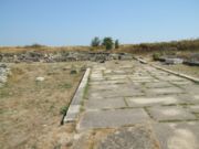
The final steps utilized concrete, which the Romans had exclusively rediscovered. They seem to have mixed the mortar and the stones in the fossa. First a several-inch layer of coarse concrete, the rudus, then a several-inch layer of fine concrete, the nucleus, went onto the pavement or statumen. Into or onto the nucleus went a course of polygonal or square paving stones, such as you see in the picture, called the summa crusta. The crusta was crowned for drainage.
It is unclear that any standard terminology was used; the words for the different elements perhaps varied from region to region. Today the concrete has worn from the spaces around the stones, giving the impression of a very bumpy road, but the original surface was no doubt much closer to being flat. These remarkable roads are resistant to rain, freezing and flooding. They needed little repair.
Surpassing obstacles
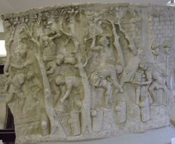
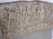
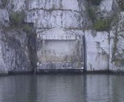
The Roman road (from Cazane near Iron Gates) was carved in stone about 1.5-1.75 m, the rest of the road, above the Danube, was made from wooden structure. Roman architects preferred to engineer solutions to obstacles rather than circumvent them.
River crossings were achieved by bridges, or pontes. Single slabs went over rills. A bridge could be of wood, stone, or both. Wooden bridges were constructed on pilings sunk into the river, or on stone piers. Larger or more permanent bridges required arches. Roman bridges were so well constructed that many are in use today.
Causeways were built over marshy ground. The road was first marked out with pilings. Between them were sunk large quantities of stone so as to raise the causeway 6 feet above the marsh. In the provinces, the Romans often did not bother with a stone causeway, but used log roads (pontes longi).
Outcroppings of stone, ravines, or hilly or mountainous terrain called for cuttings and tunnels. Roman roads generally went straight up and down hills, rather than in a serpentine pattern. Grades of 10%-12% are known in ordinary terrain, 15%-20% in mountainous country.
Financing
Financing road building was a Roman government responsibility. Maintenance, however, was generally left to the province. The officials tasked with fund raising were the curatores viarum, in which you can see the English word, curator. They had a number of methods available to them. Private citizens with an interest in the road could contribute to its repair. High officials might distribute largesse to be used for roads. Censors, who were in charge of public morals and public works, were expected to fund repairs sua pecunia (with their own money). Beyond those means, taxes were required.
The beauty and grandeur of the roads might tempt us to believe that any Roman citizen could use them for free, but this was not the case. Tolls abounded, especially at bridges. Often they were collected at the city gate. Freight was made heavier still by import and export taxes. These were only the charges for using the roads. Costs of services on the journey went up from there.
Some Roman roads
There are many examples of roads that still follow the route of Roman roads.
Albania / Greece / Turkey
- Via Egnatia ( 146 BC) connecting Dyrrhachium to Byzantium via Thessaloniki
France
- Via Aquitania, from Narbonne, where it connected to the Via Domitia, to the Atlantic Ocean across Toulouse and Bordeaux,
- Via Domitia ( 118 BC), from Nimes to the Pyrenees, where it joins to the Via Augusta at the Col de Panissars.
Italy
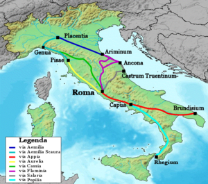
major roads
- Via Aemilia, from Ariminum to Piacenza
- Via Appia, the Appian way ( 312 BC), from Rome to Apulia ( Puglia)
- Via Aurelia ( 241 BC), from Rome to France
- Via Cassia, from Rome to Tuscany
- Via Flaminia ( 220 BC), from Rome to Ariminum
- Via Salaria, from Rome to the Adriatic Sea (in the Marches)
others
- Via Aemilia Scaura ( 109 BC)
- Via Aquillia, branches off the Appia at Capua to the sea at Vibo
- Via Amerina, from Rome to Ameria and Perusia
- Via Claudia Julia Augusta ( 13 BC)
- Via Clodia, from Rome to Tuscany forming a system with the Cassia
- Via Domitiana, coast road from Naples to Formia.
- Via Julia Augusta ( 8 BC), exits Aquileia.
- Via Labicana, southeast from Rome, forming a system with the Praenestina
- Via Ostiensis, from Rome to Ostia
- Via Postumia ( 148), from Verona across the Apennines to Genoa
- Via Popilia ( 132 BC), two distinct roads, one from Capua to Rhegium and the other from Ariminum through the later Veneto region, possibly to Pula in Istria
- Via Praenestina, from Rome to Praeneste
- Via Severiana, Terracina to Ostia
- Via Traiana Nova (Italy), from Lake Bolsena to the Via Cassia. Known by archaeology only.
-
- Most Roman roads were named after the censor who ordered their construction or reconstruction. The same person often served afterward as consul, but the road name is dated to his term as censor. If the road was older than the office of censor or was of unknown origin, it took the name of its destination or of the region through which it mainly passed. A road was renamed if the censor ordered major work on it, such as paving, repaving or rerouting.
Trans-Alpine roads
These roads connected modern Italy and Germany
- Via Claudia Augusta ( 47) from Altinum (now Venice) to Augsburg via the Reschen Pass
- Via Mala from Milan to Lindau via the San Bernardino Pass
- Via Decia
Romania
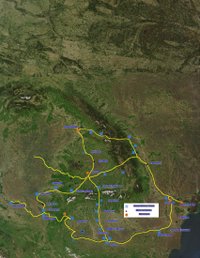
- Trajan's bridge and Iron Gates road.
- Potaissa Napoca road.
Spain
- Iter ab Emerita Asturicam, from Sevilla to Gijón. Later known as Vía de la Plata (plata means "silver" in Spanish, but in this case it is a false cognate of an Arabic word), part of the fan of the Way of Saint James. Now it is the A-66 freeway.
- Via Augusta, from Cádiz to the Pyrénées, where it joins to the Via Domitia at the Coll de Panissars, near La Jonquera. It passes through Valencia, Tarragona (anciently Tarraco), and Barcelona.
United Kingdom
- Akeman Street
- Dere Street
- Ermine Street
- Fen Causeway
- Fosse Way
- King Street
- London-West of England Roman Roads
- Peddars Way
- Stane Street
- Stanegate
- Via Devana
- Watling Street
