Lake Tanganyika
2007 Schools Wikipedia Selection. Related subjects: African Geography; General Geography
| Lake Tanganyika | |
|---|---|
|
|
|
| Coordinates | |
| Lake type | Rift Valley Lake |
| Primary sources | Ruzizi River Malagarasi River Kalambo River |
| Primary outflows | Lukuga River |
| Catchment area | 231,000 km² |
| Basin countries | Burundi The DRC Tanzania Zambia |
| Max-length | 673 km |
| Max-width | 50km / 72km |
| Surface area | 32,900 km² |
| Average depth | 570m |
| Max-depth | 1,470m |
| Water volume | 18,900 km³ |
| Shore length1 | 1,828 km |
| Surface elevation | 773m |
| Settlements | Kigoma, Tanzania Kalemie, DRC |
| 1 Shore length is an imprecise measure which may not be standardized for this article. | |
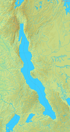
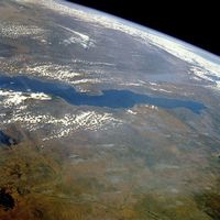
Lake Tanganyika is a large lake in central Africa (3° 20' to 8° 48' South and from 29° 5' to 31° 15' East). It is estimated to be the second largest lake in the world by volume, and the second deepest, in both cases after Lake Baikal in Siberia. The lake is divided between four countries – Burundi, Democratic Republic of the Congo (DRC), Tanzania and Zambia, with the DRC (45%) and Tanzania (41%) possessing the majority of the lake.
Geography
The lake is situated within the Western Rift of the Great Rift Valley and is confined by the mountainous walls of the valley. It is the largest rift lake in Africa and the second largest lake by surface area on the continent. It is the deepest lake in Africa and holds the greatest volume of fresh water. It extends for 673 km in a general north-south direction and averages 50 km in width. The lake covers 32,900 km², with a shoreline of 1,828km and a mean depth of 570 m and a maximum depth of 1,470 m (4,823 ft) (in the northern basin) it holds an estimated 18,900 km³ (4500 cubic miles). It has an average surface temperature of 25°C and a pH averaging 8.4. Additionally, beneath the 500m of water there is circa 4,500 metres of sediment overlaying the rock floor.
The enormous depth and tropical location of the lake prevent 'turnover' of watermasses, which means that much of the lower depths of the lake are so-called ' fossil water' and are anoxic (lacking oxygen). The catchment area of the lake covers 231,000 km², with two main rivers flowing into the lake, numerous smaller rivers and streams (due to the steep mountains that keep drainage areas small), and one major outflow, the Lukuga River, which empties into the Congo River drainage.
The major inflows are the Ruzizi River, entering the north of the lake from Lake Kivu, and the Malagarasi River, which is Tanzania's second largest river, entering in the east side of Lake Tanganyika. The Malagarasi pre-dates Lake Tanganyika and was formerly continuous with the Congo river.
Biology
The lake holds at least 250 species of cichlid fish and 150 non-cichlid species, most of which live along the shoreline down to a depth of approximately 600 feet). The largest biomass of fish, however, is in the pelagic zone (open waters) and is dominated by six species - two species of " Tanganyika sardine" and four species of predatory Lates (related to, but not the same as, the Nile Perch that has devastated Lake Victoria cichlids). Almost all (98%) of the Tanganyikan cichlid species are endemic (exclusively native) to the lake. This kind of elevated endemism occurs among the numerous invertebrates in the lake, most especially the molluscs (which possess similar forms to that of many marine molluscs), crabs, shrimps, copepods, jellyfishes, leeches, etc.
Several species of cichlid, including many shell-dwelling species, have also become popular as aquarium fish due to their unique and attractive colouration and body shapes, unusual lifestyles and relatively high intelligence.
Species of note
- Aquatic cobra.
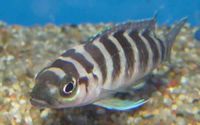
- Cyphotilapia frontosa, a striped fish native to Tanganyika.
Industry
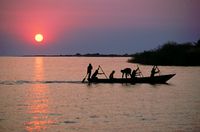
The lake's fish serve as a major source of protein for local peoples. Currently there are around 45,000 people directly involved in the fisheries operating from almost 800 sites, there around 1 million people dependent on the fishers, and Lake Tanganyika fish can be found exported throughout East Africa. Commercial fishing began in the mid-1950s and has had an extremely heavy impact on the pelagic fish species, in 1995 the total catch was around 180,000 tonnes. Former industrial fisheries, which boomed in the 1980s, have subsequently collapsed.
Transport
There are two ferries which carry passengers and cargo along the eastern shore of the lake - the MV Liemba between Kigoma and Mpulungu and the MV Mwongozo, which runs between Kigoma and Bujumbura.
- The port town of Kigoma is the railhead for the railway from Dar es Salaam in Tanzania.
- The port town of Kalemie is the railhead for the D.R. Congo rail network.
History
The first known Europeans to find the lake were the explorers Richard Burton and John Speke, in 1858. They located it while searching for the source of the Nile River. Speke continued and found the actual source, Lake Victoria.
The Lake was the scene of two famous battles, under the command of the British Officer Geoffrey Spicer-Simson. It was retold in a book by Giles Foden entitled Mimi and Toutou Go Forth. The Bizarre Battle for Lake Tanganyika


