Gyeongju
2007 Schools Wikipedia Selection. Related subjects: Geography of Asia
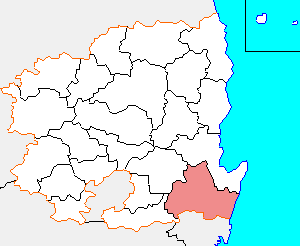
Gyeongju is a city (see Subdivisions of South Korea) and prominent tourist destination in eastern South Korea. It lies in the far southeastern corner of North Gyeongsang Province, on the coast of the Sea of Japan (East Sea). Nearby cities include the industrial centers Ulsan and Pohang. Numerous low mountains, outliers of the Taebaek range, are scattered throughout the city.
Gyeongju was the capital of the ancient kingdom of Silla, a fact to which it owes its present-day prominence. The Silla kingdom arose at the turn of the 1st millennium, and ruled most of the Korean Peninsula from the 7th to the 9th centuries. A vast number of sites from this period remain in the city today. After the kingdom fell, the city gradually declined in importance.
Today Gyeongju is a typical medium-sized city, having shared in the economic, demographic, and social trends that have shaped modern South Korea. However, amidst these trends the city has retained a distinctive identity. In tourism, it is one of South Korea's best-known destinations. In manufacturing, it profits from its proximity to major industrial centers such as Ulsan. Gyeongju is connected to nationwide rail and expressway networks, which facilitate both industrial and tourist traffic.
Geography and climate
Gyeongju lies in the southeastern corner of North Gyeongsang Province, and is therefore bounded by the metropolitan city of Ulsan on the south. Within the province, its neighbors include Pohang on the north, Cheongdo County on the southwest, and Yeongcheon on the northwest. To the east, it has no neighbour but the sea.
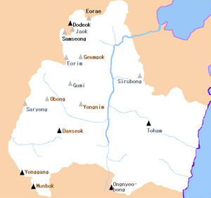
Low mountains are widespread throughout Gyeongju. The highest of these are the Taebaek Mountains, which run along the city's western border. Gyeongju's highest point, Munbok Mountain, is 1013 meters above sea level. This peak lies in Sannae-myeon, on the border with Cheongdo. East of the Taebaek range, other western peaks lie within the Jusa subrange. The city's eastern peaks, such as Toham Mountain, belong to the Dongdae Mountains, another minor subrange.
Gyeongju's drainage patterns are shaped by these lines of mountains. The Dongdae Mountains divide a narrow piedmont area on their east, and various internal river systems to the west. Most of the city's interior is drained by the small Hyeongsan River, which flows north from Ulsan and meets the sea at Pohang Harbour. The Hyeongsan's chief tributaries include the Bukcheon and Namcheon, which join it in Gyeongju Basin. The southwestern corner of Gyeongju, on the far side of the Taebaek range, drains into the Geumho River, which then flows into the Nakdong. A small area of the south, just west of the Dongdae range, drains into the Taehwa River, which flows into the Bay of Ulsan.
The Gyeongju coastline runs for 33 kilometers between Pohang in the north and Ulsan in the south. There are no islands or large bays, only the small indentations made by the small streams flowing off of the Dongdae ridgeline. Because of this, the city has no significant ports. However, there are 12 small harbors. One such harbour in Gyeongju's southeast corner is home to the Ulsan base of the National Maritime Police. This base is responsible for security over a wide area of South Korea's east-central coast.
Thanks to its coastal location, Gyeongju has a slightly milder and wetter climate than more inland regions of Korea. In general, however, the city's climate is typical of South Korea. It has hot summers and cool winters, with a monsoon season between late June and early August. As on the rest of Korea's east coast, autumn typhoons are not uncommon. The average annual rainfall is 1,091 millimeters, and the average annual temperature is 12.2°C.
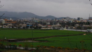
Gyeongju's historic city centre lies on the banks of the Hyeongsan in Gyeongju Basin. This lowlying area has been subject to repeated flooding throughout recorded history, often as a result of typhoons. On average, chronicles report a major flood every 27.9 years, beginning in the first century. Modern flood control mechanisms brought about a dramatic reduction in flooding in the later 20th century. The last major flood occurred in 1991, when the Deokdong Lake reservoir overflowed due to Typhoon Gladys.
History
The early history of Gyeongju is closely tied to that of the Silla kingdom, of which it was the capital. Gyeongju first enters non-Korean records as Saro-guk, during the Samhan period in the early Common Era. Korean records, probably based on the dynastic chronicles of Silla, record that Saro-guk was established in 57 BCE, when six small villages in the Gyeongju area united under Bak Hyeokgeose. As the kingdom expanded, it changed its name to Silla.
After the unification of the peninsula in the mid-7th century, Gyeongju became the centre of Korean political and cultural life. The city was home to the Silla court, and the great majority of the kingdom's elite. Its prosperity became legendary, and was reported as far away as Egypt. The population probably exceeded one million. Many of Gyeongju's most famous sites date from this Unified Silla period, which ended in the late ninth century.
Under the subsequent Goryeo (935-1392) and Joseon (1392-1910) dynasties, Gyeongju was no longer of national importance. However, it remained a regional centre. The city was made the seat of Yeongnam Province in the 10th century. It had jurisdiction over a wide area, including much of east-central Yeongnam, although this area was greatly reduced in the 13th century. In 1601, the city ceased to be the provincial capital.
Over these centuries, the city's relics suffered numerous assaults. In the 13th century, Mongol forces destroyed a nine-story wooden pagoda at Hwangnyongsa. During the Seven Year War, Japanese forces burned the wooden structures at Bulguksa. Not all damage was due to invasions, however. In the early Joseon period, a great deal of damage was done to Buddhist sculptures on Namsan by Neo-Confucian radicals, who hacked arms and heads off of statuary.
In the 20th century the city has remained relatively small, no longer ranking among the major cities of Korea. In the early 20th century many archaeological excavations took place, mostly on the many tombs which survived the centuries fairly well. A museum, the forerunner of the present-day Gyeongju National Museum, was set up in 1915 to exhibit the finds.
Gyeongju emerged as a railroad junction in the later years of the Japanese Occupation, as the Donghae Nambu Line and Jungang Line were established. Thanks to these improved connections, the town began to emerge as a centre of tourism. In the 1970s, Korea saw substantial industrial development, much of it centered in the Yeongnam region of which Gyeongju is a part. The POSCO steel mill in neighboring Pohang commenced operations in 1973, and the chemical manufacturing complex in Ulsan emerged in the same year. These developments helped to support the emergence of Gyeongju's manufacturing sector.
Government
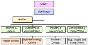
The executive branch of the government is headed by a mayor and vice-mayor. As in other South Korean cities and counties, the mayor is elected directly, while the vice-mayor holds an appointed post. The current mayor is Baek Sang Seung (백상승), elected in 2002. He is Gyeongju's third mayor to be directly elected, the fifth to preside over the city in its present form, and the 29th mayor since 1955. Like most heads of government in this region, he is a member of the conservative Grand National Party.
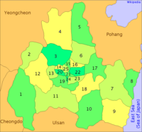
The legislative branch consists of the Gyeongju City Council, which has 24 members. The present City Council was formed from the merger of the old Gyeongju City Council with the Wolseong County Council in 1991. Most of the subdivisions of Gyeongju elect a single member to represent them in the Council, although two members represent two dong each and Angang-eup is represented by two members because of its large population. Like the mayor, the council members were last elected in 2002, except for a small number elected in more recent by-elections. In April 2004, the city government employed 1,434 people. The central administration is composed of 4 departments, 2 subsidiary organs, a chamber (the auditor), and 8 business offices. The departments oversee a total of 21 sections. In addition, there are 25 local administrative divisions, as detailed below. Each such division has a small administrative staff and a local office.
Subdivisions
The city is divided into 4 eup, 8 myeon, and 13 dong. These units are the same into which all of the cities and counties of South Korea are divided. The dong units occupy the area of the city centre, which was formerly occupied by Gyeongju-eup. Eup are typically substantial villages, whereas myeon are more rural. The current divisions are as follows:
| Romanization | Hangul | Hanja | Pop. (2004)* | Area (km²) |
|---|---|---|---|---|
| 1. Sannae-myeon | 산내면 | 山內面 | 3,695 | 142.25 |
| 2. Seo-myeon | 서면 | 西面 | 4,437 | 52.86 |
| 3. Hyeongok-myeon | 현곡면 | 見谷面 | 11,535 | 55.88 |
| 4. Angang-eup | 안강읍 | 安康邑 | 35,753 | 139.08 |
| 5. Gangdong-myeon | 강동면 | 江東面 | 9,006 | 81.48 |
| 6. Cheonbuk-myeon | 천북면 | 川北面 | 6,133 | 58.21 |
| 7. Yangbuk-myeon | 양북면 | 陽北面 | 4,524 | 120.06 |
| 8. Gampo-eup | 감포읍 | 甘浦邑 | 7,935 | 44.75 |
| 9. Yangnam-myeon | 양남면 | 陽南面 | 6,860 | 84.95 |
| 10. Oedong-eup | 외동읍 | 外東邑 | 18,347 | 110.34 |
| 11. Naenam-myeon | 내남면 | 內南面 | 6,062 | 121.96 |
| 12. Geoncheon-eup | 건천읍 | 乾川邑 | 12,235 | 90.46 |
| 13. Seondo-dong | 선도동 | 仙桃洞 | 12,753 | 28.02 |
| 14. Seonggeon-dong | 성건동 | 城乾洞 | 19,043 | 6.44 |
| 15. Hwangseong-dong | 황성동 | 隍城洞 | 31,381 | 3.84 |
| 16. Yonggang-dong | 용강동 | 龍江洞 | 16,628 | 5.06 |
| 17. Bodeok-dong | 보덕동 | 普德洞 | 2,266 | 80.94 |
| 18. Bulguk-dong | 불국동 | 佛國洞 | 3,498 | 37.26 |
| 19. Tapjeong-dong | 탑정동 | 塔正洞 | 5,924 | 19.67 |
| 20. Jungbu-dong | 중부동 | 中部洞 | 7,595 | 0.93 |
| 21. Hwango-dong | 황오동 | 皇吾洞 | 6,764 | 0.69 |
| 22. Dongcheon-dong | 동천동 | 東川洞 | 27,126 | 5.1 |
| 23. Wolseong-dong | 월성동 | 月城洞 | 7,036 | 31.4 |
| 24. Hwangnam-dong | 황남동 | 皇南洞 | 4,287 | 0.83 |
| 25. Seongdong-dong | 성동동 | 城東洞 | 5,319 | 0.64 |
*Figures based on resident registration figures made available by local government offices. For more detailed source information, see Subdivisions of Gyeongju.
People and culture
Gyeongju has produced notable individuals throughout its history. Notable Gyeongju residents in the Silla period included most of the kingdom's leading figures, not only rulers but scholars such as Choe Chi-won and generals like Kim Yu-sin. The city continued to contribute to traditional Korean thought in subsequent dynasties. Relatives of Choe Chi-won played an important role in establishing the structures of early Goryeo. In the Joseon period, Gyeongju joined the rest of Gyeongsang in becoming a hotbed of the conservative Sarim faction. Notable Gyeongju members of this faction included the 15th-century intellectual Yi Eon-jeok. In modern times the city produced writer Park Mok-wol, who did a great deal to popularize the region's culture, as well as Choe Jun, a wealthy businessman who established the Yeungnam University Foundation.
Many Korean family clans trace their origins to Gyeongju, often to the ruling elites of Silla. For example, the Gyeongju Kim clan claims descent from the rulers of later Silla. The Gyeongju Park and Gyeongju Seok clans trace their ancestry to Silla's earlier ruling families. These three royal clans played a strong role in preserving the historical precincts of Gyeongju into modern times. The Gyeongju Choe and Lee clans also trace their ancestry to the Silla elites. However, not all Gyeongju clans date to the Silla period; for instance, the Gyeongju Bing clan was founded in the early Joseon Dynasty. (For more information on the Korean clan structure, see the main article on Korean names.)
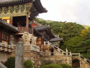
The city remains an important centre of Korean Buddhism. East of the downtown lies Bulguksa, one of South Korea's largest Buddhist temples; nearby is Seokguram, a famed Buddhist shrine. Traditional prayer locations are found on mountains throughout Gyeongju. Such mountains include Namsan in the city centre, Danseok-san and Obong-san in the west, and the low peak of Hyeong-san on the Gyeongju-Pohang border. Namsan in particular is often referred to as "the sacred mountain," due to the Buddhist shrines and statues which cover its slopes.
The city has a distinctive dialect, which it shares with northern portions of Ulsan. This dialect is similar to the general Gyeongsang dialect, but retains distinctive features of its own. Some linguists have treated the distinctive characteristics of the Gyeongju dialect as vestiges of the Silla language. For instance, the contrast between the local dialect form "소내기" (sonaegi) and the standard "소나기" (sonagi, meaning "rainshower"), has been seen as reflecting the ancient phonemic character of the Silla language.
Gyeongju's cuisine is largely identical with general Korean cuisine. However, the city is known for some local specialties. The most famous of these is " Gyeongju bread," a red-bean pastry first baked in 1939 and now sold throughout the country. Local specialties with a somewhat longer pedigree include beopju, a traditional Korean liquor.
Demographics
In recent years, Gyeongju has followed the same trends that have affected the rest of South Korea. Like the country as a whole, Gyeongju has seen its population age and the size of families shrink. For instance, the mean household size is 2.8. Because this has fallen in recent years, there are more households in the city now (100,514) than there were in 1999, even though the population has fallen.
Like most of South Korea's smaller cities, Gyeongju has seen a steady drop in population in recent years. From 1999 to 2003, the city lost 9,500 people. The primary reason for this is the number of people leaving the city, mostly seeking jobs in major cities. In the early 2000s, about 4,000 more people moved away from the city each year than moved in. During the same period, births exceeded deaths by roughly 1,000 per year, a significant number but not enough to offset the losses due to migration.
Gyeongju has a small but growing population of non-Koreans. In 2003, there were 1,778 foreigners living in Gyeongju. This number, although still a tiny fraction of the total population, was nearly double the number resident there in 1999. The growth was largely in immigrants from other Asian countries, many of whom are employed in the automotive parts industry. Countries of origin whose numbers have risen include the Philippines, China, Taiwan, Indonesia, and Vietnam. The number of residents from Japan, the United States, and Canada fell significantly in the 1999-2003 period.
Tourism
Gyeongju is a major tourist destination for South Koreans, and also for visitors from abroad. A great deal of this is due to the city's status as a centre of Silla heritage. In addition, the city government has successfully parlayed its historic status into a basis for other tourism-related developments such as conferences, festivals, and resorts.
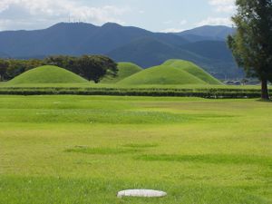
Many Silla sites are included in Gyeongju National Park. These include a number of profoundly symbolic sites, including the Royal Tomb Complex, the Cheomseongdae observatory, the Anapji pond, and the Gyerim forest. In addition, the Gyeongju National Museum hosts many artifacts from the Silla kingdom which have been excavated from sites within the city and surrounding areas, including several royal crowns and other national treasures.
Some of Gyeongju's most famous sites relate to the Silla government's patronage of Buddhism. The grotto of Seokguram and the temple of Bulguksa were the first Korean sites to be included on the UNESCO World Heritage List, in 1995. In addition, the ruins of the old Hwangnyongsa temple, said to have been Korean's largest, are preserved on the slopes of Toham Mountain. Various Silla-era stone carvings of Buddhas and bodhisattvas are found on mountainsides throughout the city, particularly on Namsan.
A significant portion of Gyeongju's tourist traffic is due to the city's successful promotion of itself as a site for various festivals, conferences, and competitions. Every year since 1962 a Silla cultural festival has been held in October to celebrate and honour the dynasty's history and culture. It is one of the major festivals of Korea. It features athletic events, folk games, music, dance, literary contests and Buddhist religious ceremonies. Other festivals include the Cherry Blossom Marathon in April, the Korean Traditional Liquor and Cake festival in March, and memorial ceremonies for the founders of the Silla Dynasty and General Kim Yu-sin.
Economy
The economy of Gyeongju is more diverse than the city's image as a tourist haven would suggest. Although tourism is an important component of the city's economy, most residents work in fields not related to tourism. More than 27,000 are employed in manufacturing, as compared to roughly 13,500 in the hospitality industry. Furthermore, the number involved in tourism has remained constant over recent years, whereas the manufacturing sector added 6,000 jobs from 1999 to 2003.
The manufacturing sector is closely tied to that in nearby cities, depending on Gyeongju's ready transit links with Ulsan, Pohang, and Daegu. The automotive parts industry, also powerful in Ulsan and Daegu, plays an important role. Indeed, of the 938 incorporated businesses in Gyeongju, more than a third are involved in the manufacture of automotive parts.
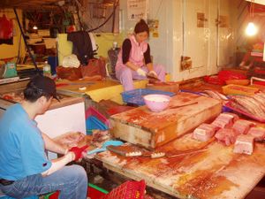
In addition, agriculture continues to play a key role, particularly in the outlying regions of Gyeongju. The city plays a leading role in the domestic production of beef and mushrooms. Fishing also takes place in coastal towns, especially in Gampo-eup in the city's northeast. There are a total of 436 registered fishing craft in the city. Much of the catch from these boats never leaves Gyeongju, going directly from the harbour to Gyeongju's many seafood restaurants.
Other sectors are also active. For instance, a small amount of quarrying activity takes place in the city. There are 57 active mines and quarries in Gyeongju. Most are engaged in the extraction of kaolin and fluorspar. A nuclear power plant is located on the coast in Yangnam-myeon. It supplies about 5% of South Korea's electricity.
Education
Formal education has a longer history in Gyeongju than anywhere else in South Korea. The Gukhak, or national academy, was established here in the 7th century, at the beginning of the Unified Silla period. Its curriculum focused on the Confucian classics. After the fall of Silla in the 10th century, the Gukhak closed. However, thanks to Gyeongju's role as a provincial centre under the Goryeo and early Joseon dynasties, the city was home to state-sponsored provincial schools ( hyanggyo) under both dynasties. During the later Joseon dynasty there were several seowon, or private Confucian academies, were set up in the city.
Today, the educational system of Gyeongju is the same as elsewhere in the country. Schooling begins with preschools, of which there are 65 in the city. This is followed by 6 years in elementary schools, of which Gyeongju has 46. Subsequently students pass through 3 years of middle school. There are 19 middle schools in Gyeongju. High-school education, which lasts for three years, is not compulsory, but the most students do attend and graduate from high school. Gyeongju is home to 21 high schools, of which 11 provide specialized technical training. At each of these levels, there is a mix of public and private institutions. All are overseen by the Gyeongju bureau of North Gyeongsang's Provincial Office of Education. Gyeongju is also home to a school for the mentally disabled, which provides education to students from preschool to adult age.
Gyeongju is also home to four institutions of tertiary education. The smallest of these, Sorabol College, is a small technical college of the sort found in many small Korean cities. Each of Gyeongju's three universities reflects the city's unique role. Dongguk and Uiduk universities are Buddhist institutions, reflecting that religion's enduring link to the city. Gyeongju University, formerly Korea Tourism University, is strongly focused on tourism, reflecting the importance of tourism in the region.
Transportation
The city lies at the junction of two minor lines operated by the Korean National Railroad. The Jungang Line runs from Seoul to Gyeongju, and also carries trains from the Daegu Line, which originates in Dongdaegu. In Gyeongju, the Jungang line connects to the Donghae Nambu Line which goes between Pohang and Busan.
The Gyeongbu Expressway, which runs from Seoul to Busan, passes through Gyeongju. In addition, there are six national highways which crisscross the city. Thanks to the city's popularity as a tourist destination, nonstop bus service is available from most major cities in South Korea.
High-speed trains do not currently serve Gyeongju, in part because the Gyeongbu Line does not pass through the city. However, high-speed service will be available after the completion of the Daegu-Busan portion of the KTX line, scheduled for 2010. The trains will stop at Singyeongju Station, in Geoncheon-eup south of Gyeongju's city centre.

