From Wikipedia, the free encyclopedia
 No higher resolution available.EUenl.gif
 (262 × 160 pixel, file size: 22 KB, MIME type: image/gif)
 |
This is a file from the Wikimedia Commons. The description on its description page there is shown below. |
|
|
Commons is attempting to create a freely licensed media file repository. You can help.
|
Summary
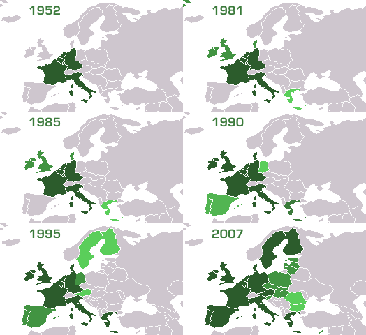
Founding and enlarging the EU. Image made using the freely licenced maps at commons: EU-6, EU-9, EU-10, EU-12, EU-15, EU-25, EU-27
Enlargements
-
1952– 58 – founding members: Belgium, France (with Algeria), Italy, Luxembourg, West Germany*, Netherlands (*in 1990 reunified with former East Germany, Algeria was an integral part of France until 1962)
-
1962 - Algeria gains independence from France and leaves.
-
1973 – First Enlargement: Denmark (with Greenland but without Faroe Islands) Ireland, United Kingdom
-
1981 – Second "southern (part I)" Enlargement: Greece
-
1986 – Third "southern (part II)" Enlargement: Portugal, Spain
-
1995 - Fourth Enlargement: Austria, "northern (in part)": Finland, Sweden
-
2004 – Fifth "eastern (part I)" Enlargement: Czech Republic, Cyprus, Estonia, Hungary, Latvia, Lithuania, Malta, Poland, Slovakia, Slovenia
-
2007 – Fifth "eastern (part II)" Enlargement: Bulgaria, Romania
(note: the very top left corner is part of Greenland)
Licensing
I, the author of this work, hereby publish it under the following license:
 |
Permission is granted to copy, distribute and/or modify this document under the terms of the GNU Free Documentation License, Version 1.2 or any later version published by the Free Software Foundation; with no Invariant Sections, no Front-Cover Texts, and no Back-Cover Texts. A copy of the license is included in the section entitled " GNU Free Documentation License".
Aragonés | العربية | Asturianu | Български | বাংলা | ইমার ঠার | Brezhoneg | Bosanski | Català | Sinugboanong Binisaya | Česky | Dansk | Deutsch | Ελληνικά | English | Esperanto | Español | Eesti | Euskara | فارسی | Suomi | Français | Galego | עברית | Hrvatski | Magyar | Bahasa Indonesia | Ido | Íslenska | Italiano | 日本語 | ქართული | 한국어 | Kurdî / كوردي | Latina | Lëtzebuergesch | Lietuvių | Bahasa Melayu | Nnapulitano | Nederlands | Norsk (nynorsk) | Norsk (bokmål) | Polski | Português | Română | Русский | Slovenčina | Slovenščina | Shqip | Српски | Svenska | తెలుగు | ไทย | Türkçe | Українська | اردو | Tiếng Việt | Volapük | 中文(简体) | 中文(繁體) | +/- |
|
File links
The following pages on the English Wikipedia link to this file (pages on other projects are not listed):
Category: Maps of the European Union

