Image:Locationmap Korea.png
From Wikipedia, the free encyclopedia
Locationmap_Korea.png (250 × 115 pixel, file size: 4 KB, MIME type: image/png)
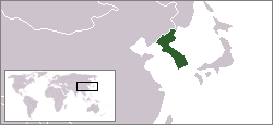
This map shows the location of the Korean peninsula.
This map was created using the existing Image:LocationSouthKorea.png contributed by User:Vardion.

Permission is granted to copy, distribute and/or modify this document under the terms of the GNU Free Documentation License, Version 1.2 or any later version published by the Free Software Foundation; with no Invariant Sections, no Front-Cover Texts, and no Back-Cover Texts.
Subject to disclaimers.
File history
Legend: (cur) = this is the current file, (del) = delete this old version, (rev) = revert to this old version.
Click on date to download the file or see the image uploaded on that date.
- (del) (cur) 18:18, 16 August 2004 . . Kokiri ( Talk | contribs) . . 250×115 (3,976 bytes) (map showing location of the Korean peninsula)
-
Edit this file using an external application
See the setup instructions for more information.
File links
- Korea
- Korean Peninsula
- Joseon Dynasty
- Korea under Japanese rule
- Korean Empire
- Category:Christianity in Korea
- User:TooChinKim
- Portal:Korea
- Portal:Korea/Intro
- North Korea-South Korea relations
- User:Visviva/Korea
- Category:Roman Catholic Church in Korea
Category: GFDL images