From Wikipedia, the free encyclopedia
 |
This is a file from the Wikimedia Commons. The description on its description page there is shown below. |
|
|
Commons is attempting to create a freely licensed media file repository. You can help.
|
Summary
Español: Expansión territorial francesa 1552-1798
- Former French version : Image:France 1552 to 1798-fr.png
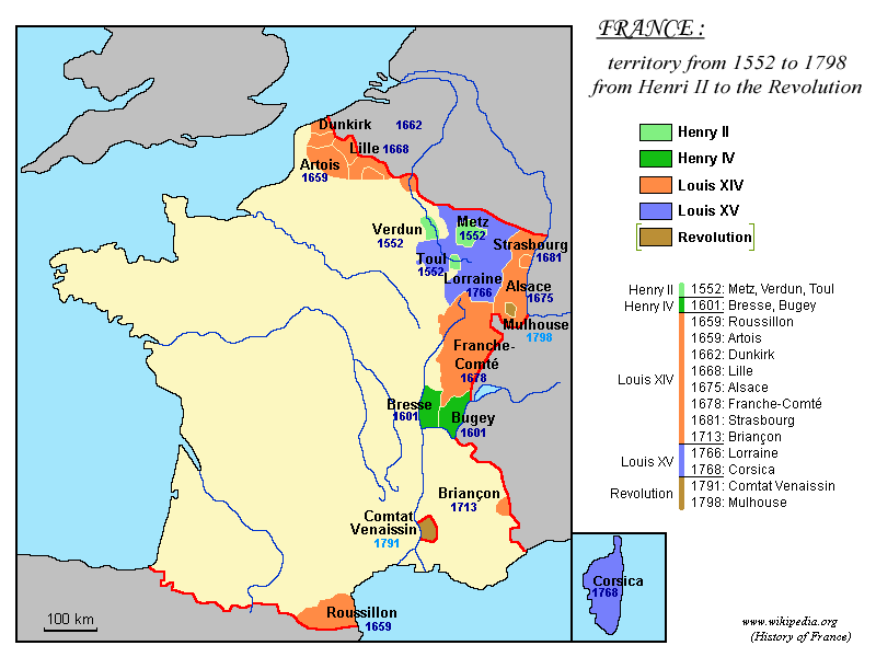
Conquests 1552-1798 (with : Henry II, Henry IV, Louis XIV, Louis XV, Frech Revolution.)
1552 : Les Trois Évêchés ( en:Metz, en:Verdun, en:Toul).
1601: en:Bresse, en:Bugey
1659: en:Roussillon
1659: en:Artois
1662: en:Dunkirk
1668: en:Lille
1675: en:Alsace
1678: en:Franche-Comté
1681: en:Strasbourg
1713: en:Briançon
1766: Lorraine
1768: en:Corsica
1791: en:Comtat Venaissin
1798: en:Mulhouse
Map created in English by Yug ( fr:Image:France_1552_to_1798.gif) ; colour modifications by Sting
This map was made or improved by the Wikigraphists of the Atelier graphique. You can propose maps or images to clean up and improve as well.
Cette carte a été créée ou améliorée par les Wikigraphistes de l' Atelier graphique. Vous pouvez également y proposer des cartes ou des images à améliorer.
Licensing
 |
Permission is granted to copy, distribute and/or modify this document under the terms of the GNU Free Documentation License, Version 1.2 or any later version published by the Free Software Foundation; with no Invariant Sections, no Front-Cover Texts, and no Back-Cover Texts. A copy of the license is included in the section entitled " GNU Free Documentation License".
العربية | Asturianu | Български | বাংলা | ইমার ঠার | Brezhoneg | Bosanski | Català | Sinugboanong Binisaya | Česky | Dansk | Deutsch | Ελληνικά | English | Esperanto | Español | Eesti | Euskara | فارسی | Suomi | Français | Galego | עברית | Hrvatski | Magyar | Bahasa Indonesia | Ido | Íslenska | Italiano | 日本語 | ქართული | 한국어 | Kurdî / كوردي | Latina | Lëtzebuergesch | Lietuvių | Bahasa Melayu | Nnapulitano | Nederlands | Norsk (nynorsk) | Norsk (bokmål) | Polski | Português | Română | Русский | Slovenčina | Slovenščina | Shqip | Српски | Svenska | తెలుగు | ไทย | Türkçe | Українська | اردو | Tiếng Việt | Volapük | 中文(简体) | 中文(繁體) | +/- |
File links
The following pages on the English Wikipedia link to this file (pages on other projects are not listed):
-
Early Modern France
-
Ancien Régime in France
-
Image:France 1552-1798.png
Category: Maps of the history of France

