Image:Population density of Ireland map.png
From Wikipedia, the free encyclopedia
Population_density_of_Ireland_map.png (350 × 421 pixel, file size: 6 KB, MIME type: image/png)
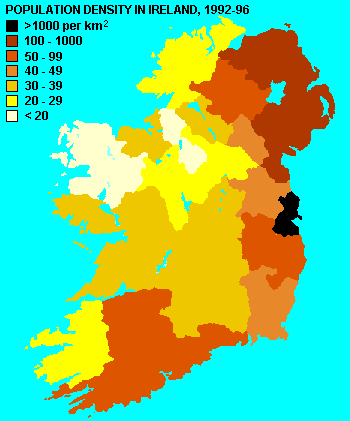
Map of Ireland's population density, taken from [: http://www.wesleyjohnston.com/users/ireland/maps/island_density.gif] with text removed and converted to PNG.
 |
This work has been (or is hereby) released into the public domain by the copyright holder. This applies worldwide. In case this is not legally possible: |
Note: This image originally had the text "Unlike the rest of this site, this map is declared to be in the public domain." in the lower right corner. I removed this notice because it distracts from the article it is used in, and since it is public domain this notice need not be retained.
File history
Legend: (cur) = this is the current file, (del) = delete this old version, (rev) = revert to this old version.
Click on date to download the file or see the image uploaded on that date.
- (del) (cur) 00:08, 15 March 2005 . . NTK ( Talk | contribs) . . 350×421 (5,925 bytes) (Map of Ireland's population density, taken from [http://www.wesleyjohnston.com/users/ireland/maps/island_density.gif] with text removed and converted to PNG. {{PD}})
-
Edit this file using an external application
See the setup instructions for more information.
File links
Categories: Copyright holder released public domain images | Maps of Northern Ireland