Image:Lakechad map.png
From Wikipedia, the free encyclopedia
No higher resolution available.
Lakechad_map.png (588 × 362 pixel, file size: 38 KB, MIME type: image/png)
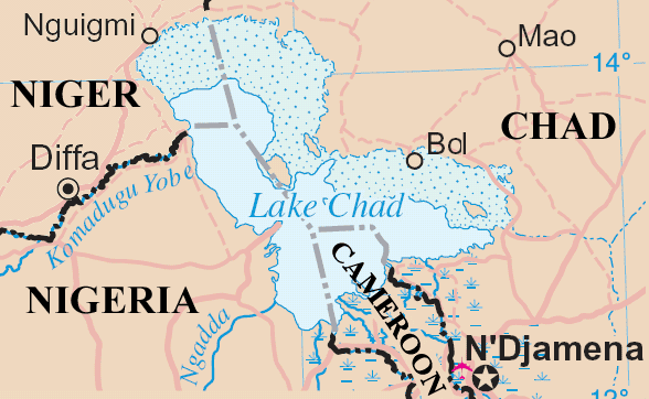
Lake Chad and surrounding area
Map adapted from http://www.un.org/Depts/Cartographic/map/profile/niger.pdf
 |
Modified UN maps are to be considered in the public domain. This applies worldwide The UN maps is an open source material. You can use them to make your own maps. You do not need our permission for that. Please be advised that the UN name and reference number should not appear on any modified map. The UN map is a UN document and cannot be modified. You can say something like "Based on UN map no..." -- Vladimir Bessarabov (UNCS Cartographer), 13 April 05 |
File history
Legend: (cur) = this is the current file, (del) = delete this old version, (rev) = revert to this old version.
Click on date to download the file or see the image uploaded on that date.
- (del) (cur) 22:37, 4 May 2005 . . ChrisO ( Talk | contribs) . . 588×362 (38,987 bytes) (Lake Chad and surrounding area Map adapted from http://www.un.org/Depts/Cartographic/map/profile/niger.pdf {{PD}})
-
Edit this file using an external application
See the setup instructions for more information.
File links
The following pages on the English Wikipedia link to this file (pages on other projects are not listed):
- Lake Chad
- Quadripoint
Category: UN map images