Image:Greatrift.jpg
From Wikipedia, the free encyclopedia
- Image
- File history
- File links
No higher resolution available.
Greatrift.jpg (300 × 318 pixel, file size: 28 KB, MIME type: image/jpeg)
|
|
This is a file from the Wikimedia Commons. The description on its description page there is shown below. |
|
|
Summary
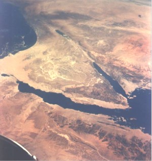
Español: La región del Sinaí desde el espacio. Al oeste se sitúa el golfo de Suez y a la derecha el de Eilat
This image was taken from the English Wikipedia, where it was uploaded by Pollinator.
Original description -
- From NASA Photo taken during Gemini XI mission. Permission to use granted by NASA according to NASA Image guidelines: http://www.nasa.gov/audience/formedia/features/MP_Photo_Guidelines.html
 |
This file is in the public domain because it was created by NASA. NASA copyright policy states that "NASA material is not protected by copyright unless noted". ( NASA copyright policy page or JPL Image Use Policy). Warnings:
|
|
File links
The following pages on the English Wikipedia link to this file (pages on other projects are not listed):
- Great Rift Valley
- Location hypotheses of Atlantis
- Arava Institute for Environmental Studies