Image:Wpdms east west new jersey.png
From Wikipedia, the free encyclopedia
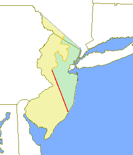
Wpdms_east_west_new_jersey.png (273 × 318 pixel, file size: 5 KB, MIME type: image/png)
The Provinces of East Jersey and West Jersey. The Keith Line of 1687 is shown in red. The Coxe and Barclay line of 1688 is shown in orange.
© 2003 Matthew Trump.

Permission is granted to copy, distribute and/or modify this document under the terms of the GNU Free Documentation License, Version 1.2 or any later version published by the Free Software Foundation; with no Invariant Sections, no Front-Cover Texts, and no Back-Cover Texts.
Subject to disclaimers.
File history
Legend: (cur) = this is the current file, (del) = delete this old version, (rev) = revert to this old version.
Click on date to download the file or see the image uploaded on that date.
- (del) (cur) 00:26, 25 February 2004 . . Decumanus ( Talk | contribs) . . 273×318 (5,133 bytes) (East and West New Jersey, 1688)
-
Edit this file using an external application
See the setup instructions for more information.
File links
- Sussex County, New Jersey
- West Jersey
- East Jersey
- Border between West Jersey and East Jersey
- Province of New Jersey
- History of New Jersey
- Talk:New York-New Jersey Line War
- Keith line
- Quintipartite Deed
- Colonial history of New Jersey
Categories: GFDL images | Historical maps of the United States