Image:Gadsden Purchase Cities.png
From Wikipedia, the free encyclopedia
Gadsden_Purchase_Cities.png (533 × 327 pixel, file size: 19 KB, MIME type: image/png)
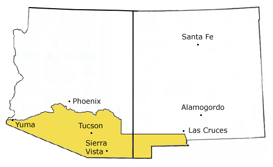
Boundaries of the Gadsden Purchase (with modern-day state boundaries of Arizona and New Mexico and nearby modern-day cities), graphic assembled by me, adapted from public domain and GFDL sources.
Original without cities can be found at Image:Gadsden_Purchase.jpg.

Permission is granted to copy, distribute and/or modify this document under the terms of the GNU Free Documentation License, Version 1.2 or any later version published by the Free Software Foundation; with no Invariant Sections, no Front-Cover Texts, and no Back-Cover Texts.
Subject to disclaimers.
File history
Legend: (cur) = this is the current file, (del) = delete this old version, (rev) = revert to this old version.
Click on date to download the file or see the image uploaded on that date.
- (del) (cur) 03:44, 23 March 2005 . . HashBrownCipher ( Talk | contribs) . . 533×327 (19,784 bytes) (Reverted to earlier revision)
- (del) (rev) 03:43, 23 March 2005 . . HashBrownCipher ( Talk | contribs) . . 533×327 (19,462 bytes) (Reverted to earlier revision)
- (del) (rev) 19:33, 28 March 2004 . . RadicalBender ( Talk | contribs) . . 533×327 (19,784 bytes) (Now with extra Santa Fe!)
- (del) (rev) 19:28, 28 March 2004 . . RadicalBender ( Talk | contribs) . . 533×327 (19,462 bytes) (Boundaries of the Gadsden Purchase (now in .png format))
-
Edit this file using an external application
See the setup instructions for more information.
File links
- Gadsden Purchase
- History of Arizona
- Mexican period of Arizona
Categories: GFDL images | Historical maps of the United States