Image:BAMS climate assess boulder water vapor 2002.gif
From Wikipedia, the free encyclopedia
- Image
- File history
- File links
No higher resolution available.
BAMS_climate_assess_boulder_water_vapor_2002.gif (775 × 425 pixel, file size: 14 KB, MIME type: image/gif)
|
|
This is a file from the Wikimedia Commons. The description on its description page there is shown below. |
|
|
Summary

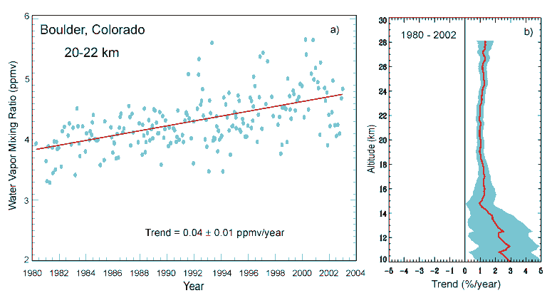
Stratospheric water vapor 1% increase.
30% may be due to increased methane.
- Observations using balloon-borne frost-point hygrometers, have detected an approximately 1% per year increase in stratospheric water vapor at Boulder, Colorado, since 1980. Besides implications for climate change, increased water vapor can affect the rate of chemical ozone loss, for example, by increasing the incidence of polar stratospheric clouds. Satellite measurements of water vapor, although not of adequate length for accurate trend determination, suggest that the increase may extend to other latitudes.
- Observations have provided evidence for a widespread increase in stratospheric water vapor, which plays a role both in cooling the lower stratosphere and in depleting ozone through chemical interactions, thereby contributing to climate processes. However, the water vapor trends are not fully defined, nor are their cause understood.
- Stratospheric water vapor measurements at a single location (Boulder, Colorado, U.S., 40°N) for the period 1981-2000 show a statistically significant increase of approximately 1%/year over altitudes 15-28 km. For the shorter period 1991-2001, global satellite measurements covering latitudes 60°N-60°S show a similar trend of 0.6-0.8%/year for altitudes ~25-50 km, but no significant trend at lower altitudes. The increases in water vapor are substantially larger than can be explained by tropospheric methane trends. Characterization of stratospheric water vapor trends is limited by the lack of global long-term measurements.
Licensing
 |
This image is in the public domain because it contains materials that originally came from the U.S. National Oceanic and Atmospheric Administration. |
 |
Source: http://www.cmdl.noaa.gov/hotitems/watervapor.html
File links
The following pages on the English Wikipedia link to this file (pages on other projects are not listed):
- Greenhouse gas
- Water vapor
- User:SEWilco
- User:SEWilco/Images
- Effects of global warming
- Talk:2006 Atlantic hurricane season/Archive 4
- User:Hard Raspy Sci/WV