Image:Tigr-euph.png
From Wikipedia, the free encyclopedia
- Image
- File history
- File links
No higher resolution available.
Tigr-euph.png (300 × 300 pixel, file size: 16 KB, MIME type: image/png)
|
|
This is a file from the Wikimedia Commons. The description on its description page there is shown below. |
|
|
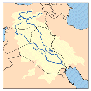
This is a map of the Tigris - Euphrates Watershed. I, Karl Musser, created it based on USGS data.
|
File links
The following pages on the English Wikipedia link to this file (pages on other projects are not listed):
- Euphrates
- Tigris
- Kurdistan
- User:Kmusser/Images
- Portal:Kurdistan/Selected picture/2007/March
- Portal:Kurdistan/Selected picture/2007
- Iran-Iraq boundary