Image:Han Civilisation.png
From Wikipedia, the free encyclopedia
- Image
- File history
- File links

Size of this preview: 800 × 591 pixel
Image in higher resolution (880 × 650 pixel, file size: 1 MB, MIME type: image/png)
|
|
This is a file from the Wikimedia Commons. The description on its description page there is shown below. |
|
|


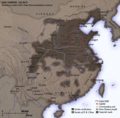
| Description | NotesCreated and copyright (2006) by Yeu Ninje. Released under the GNU FDL. This map shows the world as was known to en:Han Dynasty en:China in en:2 CE. The shaded areas show the extent of Han civilisation. I've based this on the existence of settlements under direct Han political authority or military control according to Tan Qixiang (ed.), Zhongguo lishi ditu (中国历史地图集; 1982). The international boundary shown is the border claimed by the en:People's Republic of China. Compare the territories of the historical Han dynasty and the territories over which the modern Chinese state claims sovereignty. Territorial garrisonsThe headquarters of chief commandants (都尉) are shown in yellow. Chief commandants commanded territorial garrisons and were responsible for the supression of local armed threats and supervision of recruitment for military service. Note that these were concentrated on the frontiers, especially on the northern border region. When in the interior of the Han empire, they were often placed near en:iron or en:salt industries, or on important communication routes. Dependent states (屬國) are shown in green. These were usually mixed settlements of Chinese and Xiongnu or more commonly, en:Qiang, under Han administration. The Great WallDuring most of the Western Han period, the en:Great Wall served as a line of demarcation between Han and non-Chinese peoples, most notable of whom were the en:Xiongnu. The line of the Great Wall was extended by Emperor Wu along the en:Gansu corridor (the commanderies based at Dunhuang, Lufu, Lude and Guzang). This, along with walls north of the great loop of the en:Yellow River (beyond Wuyuan), provided the front line defences against the Xiongnu. A second line was maintained along the old Qin wall (the one that passes close to Fushi and Didao), which was important even into the en:1st century. Both the lines of the Great Wall and Yellow River are based on Tan Qixiang (ed.), Zhongguo lishi ditu (中国历史地图集; 1982). Note that the Yellow River is considerably to the north of its present flow. Routes of communicationThe broad outline of communication and transport routes from the capital en:Chang'an is marked in white. These were based on en:Qin Dynasty imperial highways, Han roads (such as the Chang'an-Anyi-Taiyuan-Yu road) and navigable riverways (such as the Chenliu and Shouchun route). The long road extending west from Chang'an to the " en:Western Regions" is often known as the en:Silk Road. These are based in part on the reconstruction of early Chinese roads and waterways by en:Joseph Needham in Science and Civilisation, Vol. IV, (1954), and the additions of en:Rafe de Crespigny in Generals of the South (1992). The northern and southern routes of the Silk Road in the Western Regions is based on Map 16 in Cambridge History of China, vol. 1, (1986). The Western RegionsFrom the end of the en:2nd century BC, Han China fought with the Xiongnu over control of the Western Regions. By the time that they established the office of Protector General of the Western Regions (at Wulei) in en:60 BC or en:59 BC, the entire region was dominated by the Chinese. Tributary city-states, in light orange, sent periodic tribute to Chang'an and were rewarded by the Han court. TransliterationNames of non-Chinese peoples and states have been purposely left with their Chinese names (e.g. Dayuan instead of en:Fergana; Gaogouli instead of en:Goguryeo) to reflect the fact that our knowledge of participants in the Han world order comes almost exclusively from Chinese sources. Chinese names are transliterated by en:pinyin (e.g. Dayuan instead of Ta-yuan). Transliteration of non-Chinese peopes and states follows the pronunciation guides given in the Hou Han shu. They often diverge from the Mandarin pronunciations which are now standard: 婼羌 Er-Qiang; 鄯善 Shanshan; 且末 Jumo; 小宛 Xiao-Yuan; 精絕 Jingjue; 戎盧 Ronglu; 扜彌 Wumi; 渠勒 Jule; 于闐 Yutian; 皮山 Pishan; 烏秅 Wucha; 西夜 Xiye (Xiyi); 蒲 Pu; 依耐 Yinai; 無雷 Wulei; 難兜 Nandou; 罽賓 Jibin; 烏弋山離 Wuyishanli; 安息 Anxi; 大月氏 Da-Yuezhi; 康居 Kangju; 大宛 Da-Yuan; 桃槐 Taohui; 休循 Xiuxun; 捐毒 Juandu; 莎車 Shaju; 疏勒 Shule; 尉頭 Weitou; 龜茲 Qiuci; 姑墨 Gumo; 焉耆 Yanqi. Related images
|
||
|---|---|---|---|
| Source | |||
| Date | |||
| Author |
User Yeu Ninje on en.wikipedia |
||
| Permission |
|
||
| Other versions |
Originally from en.wikipedia; description page is (was) here * 21:06, 14 June 2006 [[:en:User:Yeu Ninje|Yeu Ninje]] 880×650 (1,051,992 bytes) <span class="comment">(Border of P. R. China --> Border claimed by P. R. China.)</span> * 12:44, 1 March 2006 [[:en:User:Yeu Ninje|Yeu Ninje]] 880×650 (1,054,864 bytes) <span class="comment">(more small changes.)</span> * 01:07, 26 February 2006 [[:en:User:Yeu Ninje|Yeu Ninje]] 880×650 (1,052,476 bytes) * 21:53, 25 February 2006 [[:en:User:Yeu Ninje|Yeu Ninje]] 880×650 (919,134 bytes) <span class="comment">(Created and copyright (2006) by [[:en:Yeu Ninje]]. Released under the [[:en:GNU FDL]]. )</span> |

(Uploaded using CommonsHelper or PushForCommons)
File links
- Han Dynasty
- Xiongnu
- User:Yeu Ninje/Maps
- Historical Atlas of China
- Wikipedia:Featured pictures thumbs 05
- Wikipedia:Featured picture candidates/archived removal requests 1
- Wikipedia:Picture of the day/June 2006
- User talk:Natalinasmpf/archive 5
- Wikipedia:Featured picture candidates/Han foreign relations 2 CE
- Wikipedia:Wikipedia Signpost/2006-03-13/Features and admins
- Wikipedia:Featured picture candidates/March-2006
- China
- Wikipedia:Picture of the day/June 13, 2006
- Wikipedia:POTD/June 13, 2006
- Wikipedia:POTD column/June 13, 2006
- Wikipedia:POTD row/June 13, 2006
- Portal:Geography/Featured picture/2006, week 25
- Image:Qin empire 210 BCE.png
- Wikipedia:Featured picture candidates/Han Civilisation Delist
- Portal:China/Selected article and pictures
- Portal:People's Republic of China (new)/Selected picture
- User talk:Jimbo Wales/Archive 10
- Wikipedia:Featured pictures/Diagrams, drawings, and maps
- Portal:China/Selected picture/2006
- Portal:People's Republic of China/Selected picture/2006/November
- Portal:China/Selected picture/2006/December
- Portal:Geography/Featured picture archive/2006
- User talk:Yu Ninjie/Archive 2006
- Nomadic Empires
Category: Wikipedia featured pictures