Image:Yenisei basin 7.png
From Wikipedia, the free encyclopedia

Size of this preview: 441 × 600 pixel
Image in higher resolution (514 × 699 pixel, file size: 28 KB, MIME type: image/png)
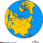
The Yenisei basin, Lake Baikal, and the settlements of Dikson, Dudinka, Turukhansk, Krasnoyarsk, Irkutsk
I used this online map creation tool to create the map, and then I manually edited out the waterways not on this map.
I fed the following latitude and longitude to the map generation tool to spot the location of the cities:
- 80.7111,73.5333, Dikson
- 86.2383,69.4438, Dudinka
- 87.9624,65.7959, Turukhansk
- 92.9756,56.0103, Krasnoyarsk
- 104.248,52.3174, Irkutsk
Related maps

Permission is granted to copy, distribute and/or modify this document under the terms of the GNU Free Documentation License, Version 1.2 or any later version published by the Free Software Foundation; with no Invariant Sections, no Front-Cover Texts, and no Back-Cover Texts.
Subject to disclaimers.
File history
Legend: (cur) = this is the current file, (del) = delete this old version, (rev) = revert to this old version.
Click on date to download the file or see the image uploaded on that date.
- (del) (cur) 02:32, 25 January 2005 . . Geo Swan ( Talk | contribs) . . 514×699 (28,720 bytes) (The Yenisei basin, Lake Baikal, and the cities of Dikson, Dudikna, Turukhansk, Krasnoyarsk, Irkutsk)
-
Edit this file using an external application
See the setup instructions for more information.
File links
- Lake Baikal
- Yenisei River
- Krasnoyarsk
- Dikson Island
- Dudinka
- Image:Dudinka and dikson 2.png
- User:Geo Swan/mymaps
- Dikson (urban-type settlement)
Category: GFDL images