Image:Yemen-map.gif
From Wikipedia, the free encyclopedia

Yemen-map.gif (330 × 355 pixel, file size: 11 KB, MIME type: image/gif)
|
|
This picture/multimedia file is now available on Wikimedia Commons as Image:Yemen-map.gif. Images which have been tagged with this template may be deleted immediately after satisfying these conditions ( CSD I8). |
Summary
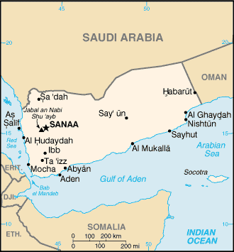
Map of Yemen from World Factbook
Licensing
 |
This work is in the public domain in the United States because it is a work of the United States Federal Government under the terms of 17 U.S.C. § 105. See Copyright. Note: This only applies to works of the Federal Government and not to the work of any individual US state, territory, commonwealth, county, subdivision, or municipality. |
File history
Legend: (cur) = this is the current file, (del) = delete this old version, (rev) = revert to this old version.
Click on date to download the file or see the image uploaded on that date.
- (del) (cur) 02:03, 23 August 2004 . . TimShell ( Talk | contribs) . . 330×355 (11,172 bytes) (Map of Yemen from World Factbook)
-
Edit this file using an external application
See the setup instructions for more information.
File links
- Geography of Yemen
- Yemen
- List of cities in Yemen
- Talk:USS Cole bombing
Categories: Map images which should be in SVG format | Images with the same name on Wikimedia Commons as of 29 March 2007 | All images with the same name on Wikimedia Commons | United States government images

