Image:Gz-map.png
From Wikipedia, the free encyclopedia
- Image
- File history
- File links
No higher resolution available.
Gz-map.png (328 × 352 pixel, file size: 10 KB, MIME type: image/png)
|
|
This is a file from the Wikimedia Commons. The description on its description page there is shown below. |
|
|
This image was copied from en.wikipedia.org. The original description was:
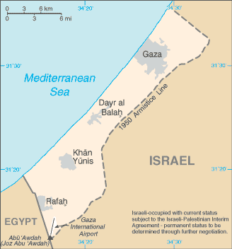
A map of the Gaza Strip showing key towns and neighbouring countries.
Taken from CIA World Factbook website on 15 August.
Public domain, as is all content from the CIA factbook.
External links
- Gaza Strip from CIA factbook
 |
This work is in the public domain in the United States because it is a work of the United States Federal Government under the terms of Title 17, Chapter 1, Section 105 of the US Code. See Copyright. Note: This only applies to works of the Federal Government and not to the work of any individual U.S. state, territory, commonwealth, county, municipality, or any other subdivision. العربية | Česky | Deutsch | Español | 한국어 | Italiano | 日本語 | Magyar | Français | Português | 简体中文 | 正體中文 | +/- < |
 |
File links
No pages on the English Wikipedia link to this file. (Pages on other projects are not counted.)