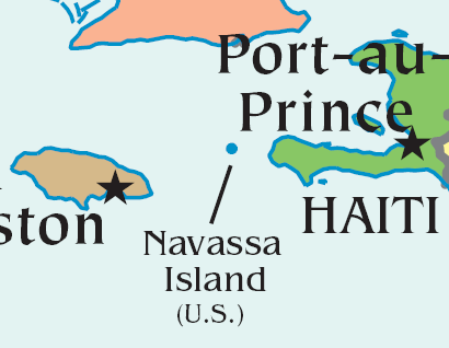
Image:Navassa-location.png
From Wikipedia, the free encyclopedia
- Image
- File history
- File links
No higher resolution available.
Navassa-location.png (410 × 318 pixel, file size: 25 KB, MIME type: image/png)
|
|
This is a file from the Wikimedia Commons. The description on its description page there is shown below. |
|
|
Summary
A map showing the location of w:en:Navassa Island, a US territory in the Caribbean Sea. This map has been cropped from the CIA Factbook World map (warning: 2MB PDF).
Licensing
 |
This image is in the public domain because it contains materials that originally came from the United States Central Intelligence Agency's World Factbook. |
 |
|
English | Français | +/- |
||
File links
The following pages on the English Wikipedia link to this file (pages on other projects are not listed):
- User:Hoshie/Images
Category: Maps of Navassa Island