Image:Canada provinces evolution-250.gif
From Wikipedia, the free encyclopedia
- Image
- File history
- File links
No higher resolution available.
Canada_provinces_evolution-250.gif (250 × 216 pixel, file size: 211 KB, MIME type: image/gif)
|
|
This is a file from the Wikimedia Commons. The description on its description page there is shown below. |
|
|
Summary
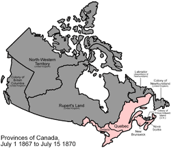
Scaled down version of Image:Canada provinces evolution.gif An animated GIF of the evolution of Canada's internal borders, from the formation of the dominion to the present.
PINK Province
BROWN Territory
GRAY Foreign land
FUCHSIA Disputed land
Made by User:Golbez.
Licensing
|
|
This file is licensed under Creative Commons Attribution 2.5 License In short: you are free to distribute and modify the file as long as you attribute its author(s) or licensor(s). |
File links
The following pages on the English Wikipedia link to this file (pages on other projects are not listed):
- Talk:Canada/Archive 11
Category: Maps of Canada