Image:Flores map.png
From Wikipedia, the free encyclopedia
- Image
- File history
- File links
No higher resolution available.
Flores_map.png (300 × 122 pixel, file size: 21 KB, MIME type: image/png)
|
|
This is a file from the Wikimedia Commons. The description on its description page there is shown below. |
|
|
This image was copied from wikipedia:en. The original description was:
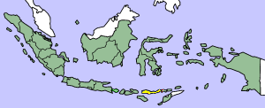
Map showing Flores Island within Indonesia
|
|
This file has been released into the public domain by the copyright holder, its copyright has expired, or it is ineligible for copyright. This applies worldwide. |
|
|
Note: This tag is obsolete! Don't use this generic template - please use instead:
العربية | česky | Deutsch | English | Español | Français | हिन्दी | Italiano | 日本語 | Norsk (nynorsk) | Português | Русский | Slovenčina | Slovenščina | Српски | Polski | Türkçe | 简体中文 | +/- |
| date/time | username | edit summary |
|---|---|---|
| 14:17, 14 March 2005 | *drew | (Map showing Flores Island within Indonesia {{PD}}) |
File links
The following pages on the English Wikipedia link to this file (pages on other projects are not listed):
- Flores
- Homo floresiensis
- Nage