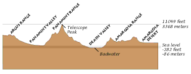
Image:High and low points in Death Valley National Park.png
From Wikipedia, the free encyclopedia
No higher resolution available.
High_and_low_points_in_Death_Valley_National_Park.png (378 × 148 pixel, file size: 3 KB, MIME type: image/png)

USGS/NPS PD image from
 |
This work is in the public domain in the United States because it is a work of the United States Federal Government under the terms of 17 U.S.C. § 105. See Copyright. Note: This only applies to works of the Federal Government and not to the work of any individual US state, territory, commonwealth, county, subdivision, or municipality. |
 |
File history
Legend: (cur) = this is the current file, (del) = delete this old version, (rev) = revert to this old version.
Click on date to download the file or see the image uploaded on that date.
- (del) (cur) 06:29, 2 February 2005 . . Maveric149 ( Talk | contribs) . . 378×148 (3,083 bytes) (USGS/NPS PD image from [http://geology.wr.usgs.gov/docs/parks/deva/ftdan1.html}<br>{{PD-USGov}})
-
Edit this file using an external application
See the setup instructions for more information.
File links
The following pages on the English Wikipedia link to this file (pages on other projects are not listed):
Categories: Diagram images which should be in SVG format | United States government images