Image:Kiribati-Caroline-highlighted.PNG
From Wikipedia, the free encyclopedia
Kiribati-Caroline-highlighted.PNG (300 × 322 pixel, file size: 57 KB, MIME type: image/png)
Summary
Summary
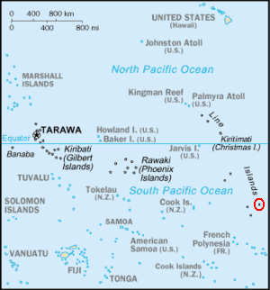
Adapted version of the post-1995 South Pacific section of Image:Kr-map.png, with Caroline Island highlighted.
|
|
This image is a map or flag taken and/or modified from the Central Intelligence Agency's World Factbook. Under United States copyright law, all information and images from the World Factbook are in the public domain |
Licensing
 |
This work is in the public domain in the United States because it is a work of the United States Federal Government under the terms of 17 U.S.C. § 105. See Copyright. Note: This only applies to works of the Federal Government and not to the work of any individual US state, territory, commonwealth, county, subdivision, or municipality. |
 |
File history
Legend: (cur) = this is the current file, (del) = delete this old version, (rev) = revert to this old version.
Click on date to download the file or see the image uploaded on that date.
- (del) (cur) 17:42, 14 June 2006 . . Seth Ilys ( Talk | contribs) . . 300×322 (58,227 bytes) (== Summary == Adapted version of the post-1995 South Pacific section of Image:Kr-map.png, with Caroline Island highlighted. {{PD-USGov-CIA-WF}})
-
Edit this file using an external application
See the setup instructions for more information.
File links
Categories: CIA World Factbook images | United States government images