Image:Guik gap.gif
From Wikipedia, the free encyclopedia

Size of this preview: 495 × 599 pixel
Image in higher resolution (1024 × 1239 pixel, file size: 465 KB, MIME type: image/gif)
| This media file is obsolete. It is advisable that you use the newer file, GIUK_gap.png. Note: This image will not be deleted unless it is explicitly nominated for deletion. |
 |
Summary
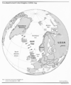
The GIUK gap is an area in the northern Atlantic Ocean that forms a naval warfare chokepoint. Its name is an acronym for Greenland, Iceland, and the United Kingdom, the gap being the open ocean between these three landmasses. The term is typically used in military topics.
source: https://www.cia.gov/csi/monograph/coldwar/pg9.gif
Licensing
 |
This work is in the public domain in the United States because it is a work of the United States Federal Government under the terms of 17 U.S.C. § 105. See Copyright. Note: This only applies to works of the Federal Government and not to the work of any individual US state, territory, commonwealth, county, subdivision, or municipality. |
File history
Legend: (cur) = this is the current file, (del) = delete this old version, (rev) = revert to this old version.
Click on date to download the file or see the image uploaded on that date.
- (del) (cur) 08:42, 29 December 2005 . . Natebjones ( Talk | contribs) . . 1024×1239 (476,597 bytes) (GIUK Gap http://www.cia.gov/csi/monograph/coldwar/pg9.gif )
-
Edit this file using an external application
See the setup instructions for more information.
File links
Categories: Obsolete images | United States government images

