Image:North Fork Toutle River valley in November 1983.jpg
From Wikipedia, the free encyclopedia
North_Fork_Toutle_River_valley_in_November_1983.jpg (543 × 353 pixel, file size: 39 KB, MIME type: image/jpeg)
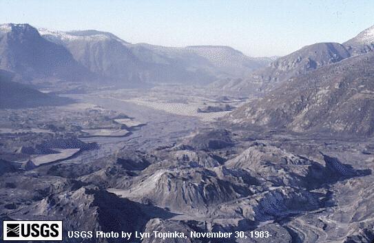
This downstream view of the North Fork Toutle River valley, north and west of St. Helens, shows part of the nearly 2/3 cubic miles (2.3 cubic kilometers) of debris avalanche that slid from the volcano on May 18. This is enough material to cover Washington, D.C. to a depth of 14 feet (4 meters). The avalanche traveled approximately 15 miles (24 kilometers) downstream at a velocity exceeding 150 miles per hour (240 kilometers/hour). It left behind a hummocky deposit with an average thickness of 150 feet (45 meters) and a maximum thickness of 600 feet (180 meters). (November 30, 1983, by Lyn Topinka, USGS/CVO)
USGS image from
This image is a work of a United States Geological Survey employee, taken or made during the course of the person's official duties. As a work of the United States Government, the image is in the public domain. For more information, see the USGS copyright policy.
File history
Legend: (cur) = this is the current file, (del) = delete this old version, (rev) = revert to this old version.
Click on date to download the file or see the image uploaded on that date.
- (del) (cur) 02:09, 23 May 2004 . . Maveric149 ( Talk | contribs) . . 543×353 (40,153 bytes) ( USGS image from [http://vulcan.wr.usgs.gov/Volcanoes/MSH/SlideSet/ljt_slideset_old.html]<br><br>{{msg:PD}})
-
Edit this file using an external application
See the setup instructions for more information.
File links
- 1980 eruption of Mount St. Helens
- Toutle River
Category: USGS images