Image:St Helens April 27, 1980 showing bulge.jpg
From Wikipedia, the free encyclopedia

St_Helens_April_27,_1980_showing_bulge.jpg (543 × 353 pixel, file size: 40 KB, MIME type: image/jpeg)
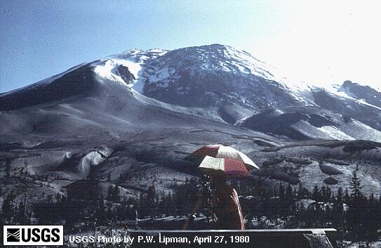
A "bulge" developed on the north side of Mount St. Helens as magma pushed up within the peak. Angle and slope-distance measurements to the bulge indicated it was growing at a rate of up to five feet (1.5 meters) per day. By May 17, part of the volcano's north side had been pushed upwards and outwards over 450 feet (135 meters). The view is from the northeast. (April 27, 1980, by Peter W. Lipman, USGS)
USGS image from
This image is a work of a United States Geological Survey employee, taken or made during the course of the person's official duties. As a work of the United States Government, the image is in the public domain. For more information, see the USGS copyright policy.
File history
Legend: (cur) = this is the current file, (del) = delete this old version, (rev) = revert to this old version.
Click on date to download the file or see the image uploaded on that date.
- (del) (cur) 02:10, 23 May 2004 . . Maveric149 ( Talk | contribs) . . 543×353 (41,324 bytes) ( USGS image from [http://vulcan.wr.usgs.gov/Volcanoes/MSH/SlideSet/ljt_slideset_old.html]<br><br>{{msg:PD}})
- (del) (rev) 02:10, 23 May 2004 . . Maveric149 ( Talk | contribs) . . 543×353 (41,324 bytes) ( USGS image from [http://vulcan.wr.usgs.gov/Volcanoes/MSH/SlideSet/ljt_slideset_old.html]<br><br>{{msg:PD}})
-
Edit this file using an external application
See the setup instructions for more information.
File links
Category: USGS images