Image:Brazil-16-map.jpg
From Wikipedia, the free encyclopedia
- Image
- File history
- File links

Brazil-16-map.jpg (379 × 516 pixel, file size: 277 KB, MIME type: image/jpeg)
|
|
This is a file from the Wikimedia Commons. The description on its description page there is shown below. |
|
|
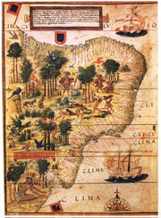
scan from 《社会历史博物馆》 ISBN 7-5347-1397-8
"社会历史博物馆" / "Social Historical Museum"
16世纪巴西的地图 / The map of Brasil in 16th century
1519年葡萄牙人绘制 / Issued in Portugal in 1519
 |
This image (or other media file) is in the public domain because its copyright has expired. This applies to the United States, Canada, the European Union and those countries with a copyright term of life of the author plus 70 years. العربية ǀ Български ǀ Català ǀ Česky ǀ Dansk ǀ Deutsch ǀ English ǀ Ελληνικά ǀ Esperanto ǀ Español ǀ Euskara ǀ فارسی ǀ Français ǀ Galego ǀ עברית ǀ हिन्दी ǀ Bahasa Indonesia ǀ Italiano ǀ 日本語 ǀ 한국어 ǀ Kurdî / كوردي ǀ Nederlands ǀ Norsk (nynorsk) ǀ Bahasa Melayu ǀ Polski ǀ Português ǀ Русский ǀ Slovenščina ǀ Shqip ǀ Suomi ǀ Svenska ǀ Türkçe ǀ 简体中文 ǀ 正體中文 ǀ +/- |
See also
File links
- Brazil
- History of Portugal
- Portugal in the Age of Discovery