From Wikipedia, the free encyclopedia
 |
This is a file from the Wikimedia Commons. The description on its description page there is shown below. |
|
|
Commons is attempting to create a freely licensed media file repository. You can help.
|
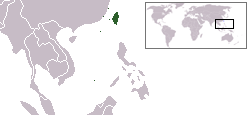
Location of regions currently under administration of the Republic of China (Taiwan): Taiwan, the Pescadores, Matsu, Quemoy, Pratas, and Itu Aba.
drawn by R.O.C in Paint and Photoshop based on Image:BlankMap-World.png
中華民國目前實際管轄區示意圖,包括:台灣島、澎湖群島、馬祖、金門、東沙群島、南沙太平島。
由 R.O.C根據 Image:BlankMap-World.png在Paint及Photoshop中繪製。
 |
I, the copyright holder of this work, hereby release it into the public domain. This applies worldwide.
In case this is not legally possible:
I grant anyone the right to use this work for any purpose, without any conditions, unless such conditions are required by law.
Afrikaans | Alemannisch | Aragonés | العربية | Български | Català | Česky | Cymraeg | Dansk | Deutsch | Ελληνικά | English | Español | Esperanto | Euskara | فارسی | Français | Galego | 한국어 | हिन्दी | Hrvatski | Ido | Bahasa Indonesia | Íslenska | Italiano | עברית | Kurdî / كوردي | Latina | Lietuvių | Magyar | Bahasa Melayu | Nederlands | Norsk (bokmål) | Norsk (nynorsk) | 日本語 | Polski | Português | Ripoarish | Română | Русский | Shqip | Slovenčina | Slovenščina | Српски | Svenska | ไทย | Türkçe | Українська | Tiếng Việt | Walon | 简体中文 | 繁體中文 | 粵語 | +/- |
File links
The following pages on the English Wikipedia link to this file (pages on other projects are not listed):

