Image:Awatplan04colours.png
From Wikipedia, the free encyclopedia
- Image
- File history
- File links
Size of this preview: 713 × 600 pixel
Image in higher resolution (1468 × 1235 pixel, file size: 33 KB, MIME type: image/png)
|
|
This is a file from the Wikimedia Commons. The description on its description page there is shown below. |
|
|
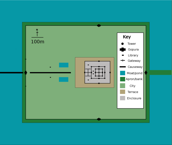
Plan of Angkor Wat. Image by User:Markalexander100. The walls, moat and causeways are to scale, as are the positions of the gateways, gopuras and towers. The positions of the libraries and the ponds are approximate.
 |
Permission is granted to copy, distribute and/or modify this document under the terms of the GNU Free Documentation License, Version 1.2 or any later version published by the Free Software Foundation; with no Invariant Sections, no Front-Cover Texts, and no Back-Cover Texts. A copy of the license is included in the section entitled " GNU Free Documentation License". العربية | Asturianu | Български | বাংলা | ইমার ঠার | Brezhoneg | Bosanski | Català | Sinugboanong Binisaya | Česky | Dansk | Deutsch | Ελληνικά | English | Esperanto | Español | Eesti | Euskara | فارسی | Suomi | Français | Galego | עברית | Hrvatski | Magyar | Bahasa Indonesia | Ido | Íslenska | Italiano | 日本語 | ქართული | 한국어 | Kurdî / كوردي | Latina | Lëtzebuergesch | Lietuvių | Bahasa Melayu | Nnapulitano | Nederlands | Norsk (nynorsk) | Norsk (bokmål) | Polski | Português | Română | Русский | Slovenčina | Slovenščina | Shqip | Српски | Svenska | తెలుగు | ไทย | Türkçe | Українська | اردو | Tiếng Việt | Volapük | 中文(简体) | 中文(繁體) | +/- |
File links