Image:Usgs map stereographic.PNG
From Wikipedia, the free encyclopedia
- Image
- File history
- File links
No higher resolution available.
Usgs_map_stereographic.PNG (534 × 181 pixel, file size: 49 KB, MIME type: image/png)
|
|
This is a file from the Wikimedia Commons. The description on its description page there is shown below. |
|
|
 |
This image should be recreated using vector graphics as an SVG file. This has several advantages; see Commons:Images for cleanup for more information. If an SVG form of this image is already available, please upload it. After uploading an SVG, replace this template with template {{ SupersededSVG|new image name.svg}} in this image. |
|
Català | Česky | Dansk | Deutsch | English | Esperanto | Español | Français | Italiano | 日本語 | 한국어 | Nederlands | Polski | Português | Русский | العربية | 正體中文 | +/- |
|
Summary
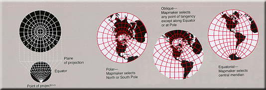
World map projection
Licensing
 |
This image is in the public domain because it contains materials that originally came from the United States Geological Survey, an agency of the United States Department of Interior. For more information, see the official USGS copyright policy |
|
File links
The following pages on the English Wikipedia link to this file (pages on other projects are not listed):
- Map projection
- Stereographic projection
Category: Images of map projections