Image:DME and ICE route map.JPG
From Wikipedia, the free encyclopedia
DME_and_ICE_route_map.JPG (626 × 408 pixel, file size: 41 KB, MIME type: image/jpeg)
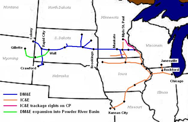
Route map of the Dakota, Minnesota and Eastern Railroad and the Iowa, Chicago and Eastern Railroad as of 2002
State and lake outlines extracted from Perry-Castañeda Library Map Collection; the Library's FAQ asserts public domain status on the original map. Railroad outlines and city and state labels by Sean Lamb ( User:Slambo), January 20, 2005; created using Microsoft Paint, based on a map published in the May 2002 issue of Trains Magazine (p. 14).

This image has been (or is hereby) released into the public domain by its creator, Slambo. This applies worldwide.
In case this is not legally possible,
the creator grants anyone the right to use this work for any purpose, without any conditions, unless such conditions are required by law.
Subject to disclaimers.
File history
Legend: (cur) = this is the current file, (del) = delete this old version, (rev) = revert to this old version.
Click on date to download the file or see the image uploaded on that date.
- (del) (cur) 02:34, 21 January 2005 . . Slambo ( Talk | contribs) . . 626×408 (42,355 bytes) (Route map of the Dakota, Minnesota and Eastern Railroad and the Iowa, Chicago and Eastern Railroad as of 2002)
-
Edit this file using an external application
See the setup instructions for more information.
File links
- User:Slambo/Gallery
- Dakota, Minnesota and Eastern Railroad
- Iowa, Chicago and Eastern Railroad
- Template talk:Infobox Railroad
- List of South Dakota railroads
Category: User-created public domain images